La montagna chiama i suoi figli, ed essi rispondono fedelmente al suo appello…
Osvaldo Cardellina, Diario alpinistico, 1964-65
Page texts: @ OsvaldoCardellina"Osva", passed away on May 2, 2022. Page owners: Christian Cardellina e Osvaldo Cardellina. Any updates from September 12, 2022: Antonio Giani, page administrator, friend and climbing companion.
Testi della pagina: @ OsvaldoCardellina "Osva", scomparso il 2 maggio 2022. Proprietari pagina:Christian Cardellina e Osvaldo Cardellina. Eventuali aggiornamenti dal 12 settembre 2022: Antonio Giani, amministratore della pagina, amico e compagno di salite.
Overview
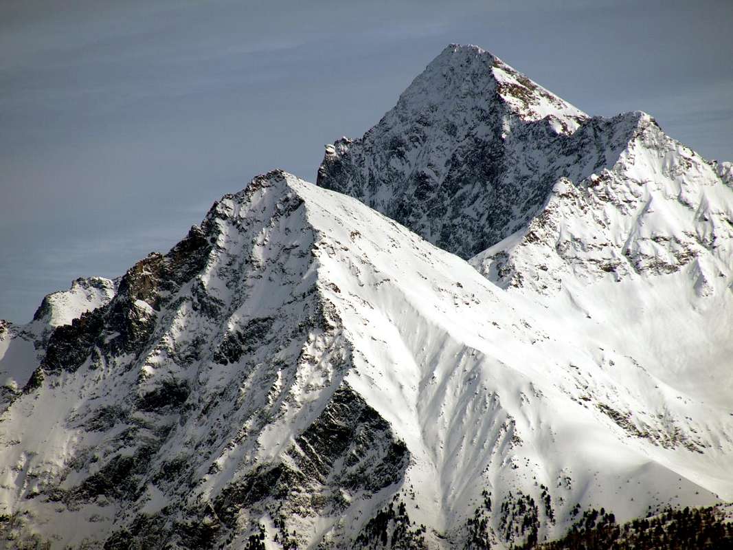
From North to Pic Garin (3.451m) beyond the Emilius's Western Ridge, by Antonio
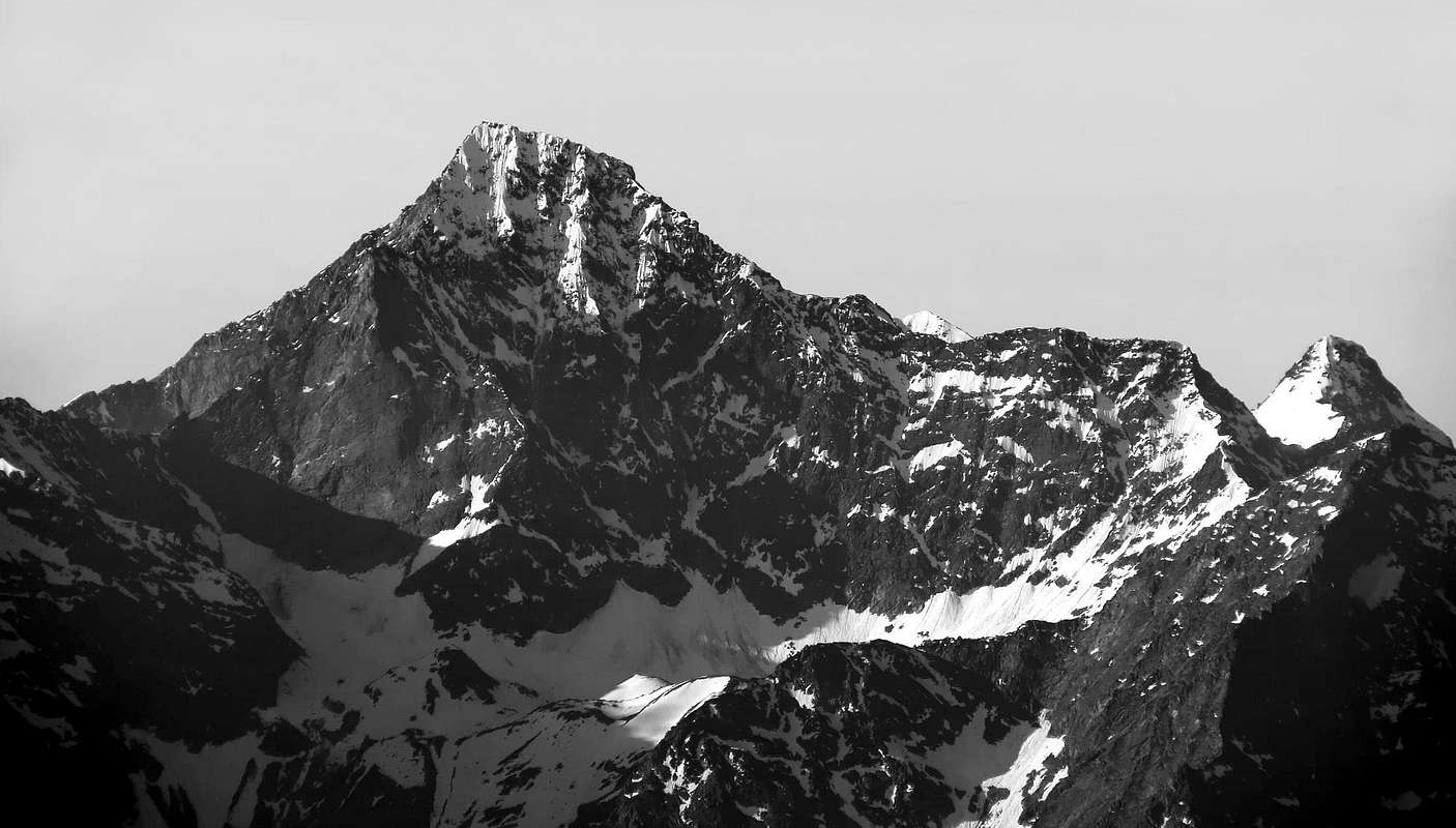
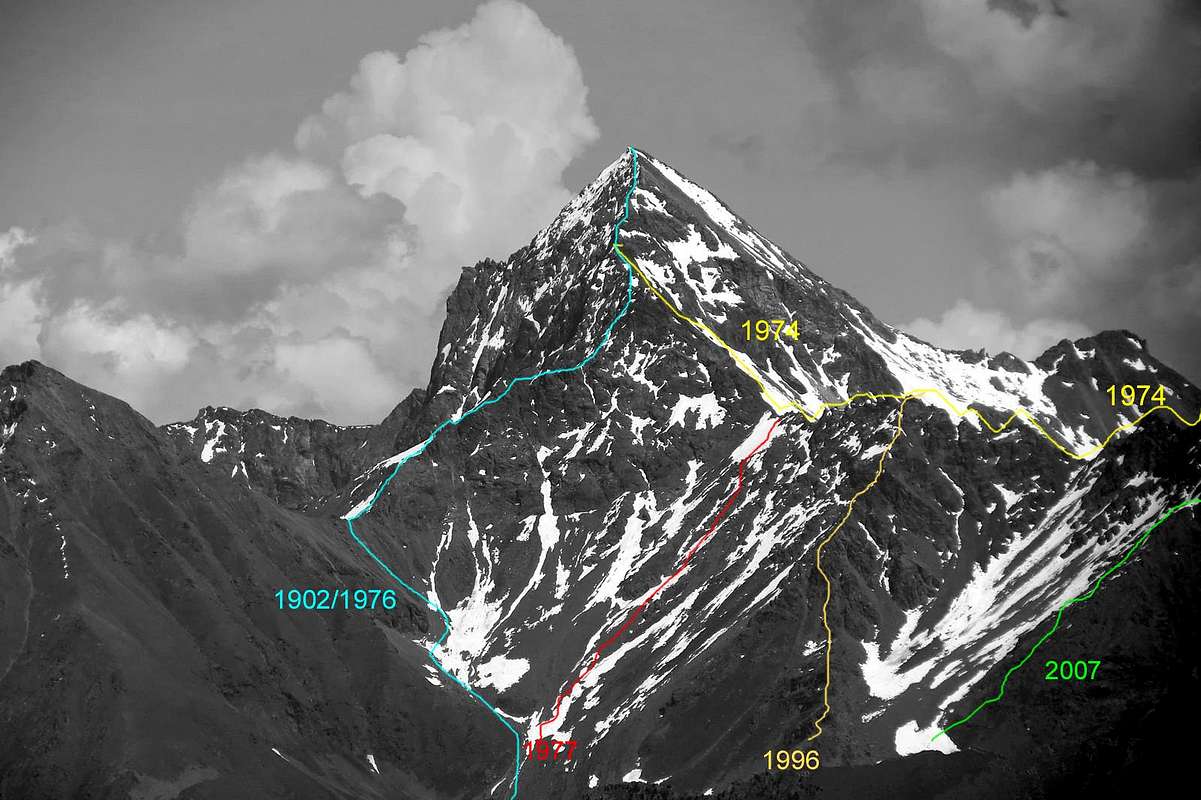
The history of this beautiful and long ridge that links the Monte Emilius to her younger sister Becca of Nona, almost an arm on the shoulder of the other, has a twofold face with diametrically opposed aspects. On one side of a ridge of classic and not so difficult nor easy path and see that since 1902, the year of its first ascent in 2004, the year of the opening of the Via Ferrata on the same, just pass a dozen groups rope climbers. The Jag 3.150 meters (3.050 feet and not as I.G.M. reported in its Charter to 1:25.000) or the Red Tower was a passage not easy and not such as to require a bypass to the North with an exposed passage in descent of about 25 meters, this and the three small, square red towers, followed by a gray vertical jump, in the end, slammed the initiative and it was not this way for everyone. How to show the steps in more than a Century. The first to arrive on the same are the two climbers Giovan Battista Devalle and Ercole Daniele accompanied by Mountain Guides Valtournanche Alexander Pession Luiugi Bich. The previous day, August 29th, 1897, had made the first ascent of the Becca of Seneva (3.086m) through the steep Western Wall facing to the Arpisson. The next day looking for the first ascent of the North Face of Emilius, who had already unsuccessfully attempted September 18th, 1878 by Martino Baretti and Luigi Bruno with the Guides of the Susa Valley Augusto and Vittorio Sibille, who had to give up not far from the Top rejected by the "verglass" with a path not easy to find (C.A.I. Bulletin 1878 page 565), even though this a group of rope climbers is rejected from the wall itself and you will have to "settle" to rise much further to the right through the wall of the North Little Emilius (3.342 m). The rope will be released on the West Ridge near the same and go up the ridge skirting the most difficult points in the North Wall. It turns out, however, the first via and the "loopholes" are necessary despite the fact that the group is made up of strong climbers (RM 1897, page 385). And even the doodles that accomplish the Abbot Joseph Maria Henry with his mule Guide Charvensod Grégoire Comé when in September 16th, 1902, after exploring downhill slopes and in the opposite Crest East while it is virgin, come down from the rope down to the near the Little Emilius before rebounding with a diagonal across the South Slope (RM 1903 pages 76/78), the next day will complete the exploration reaching the same point with some workarounds, starting from the Hill Carrel between "Becca" and Emilius. Ascent combined with some digression, but in a clean and genuine. A few days later two good climbers, and Emilio Questa with Felice Mondini, unaware that they had been preceded, run directly by the City of Aosta to even bypass them by a few, the first complete ascent (RM 1902, page 434 and 1908 page 308), the crest is made, not integrally , but entirely with the criteria of the time.
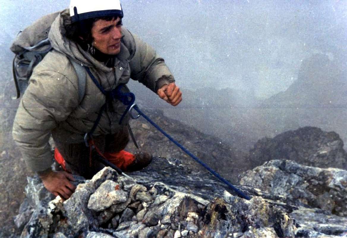
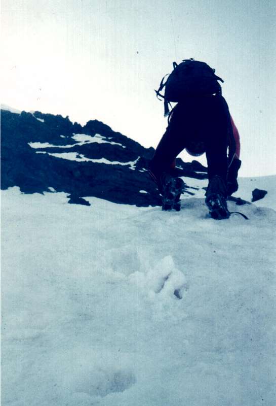
On EMILIUS Old and Original WEST CREST, 1974, 1976, and 1977, by Camillo Roberto Ferronato, & Osw.
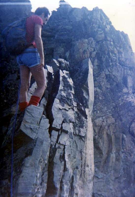
Then the ridge falls by the wayside for many years, because since 1926 the focus has turned to the North Wall, climb completely a year later by Amilcare Crétier and Lino Binel, and to the East, after the disgrace of 1929, will have to wait until 1935 with Giusto Gevasutti and Renato Chabod. We find traces of the same only in the Winter 1940/41 when the brave mountaineer Trieste Nerino Gobbo performs the first solo and the first winter. A nice firm, as well as "wild". In the next Summer we have a brilliant achievement by the Mountain Guide Aosta Giulio Adolfo "Dulo" Ourlaz who with his wife Aurora Wuillerminaz (will be shot by the Nazis) salt N-NE Edge, go down the West Ridge, goes back to the " Becca" which descend through the N-NE "Crestone" on a tour of the Vallon of almost total Arpisson. But after the war intentions are directed to the first repetition, and so we will have to Pietro "Piero" Rosset and Franco Garda in the Summer of 1946 to the East, while the same in February of '49 completed the first winter of the Edge N-NE, across the North Wall. But the real goal becomes the Black Triangle, located at the edge of the latter. After many attempts, even by illustrious names, it will be won in September 1960 by the same Mountain Guide Rosset together to champion and Valpelline Mountain Guide Angel "Angelino" Bozzetti. The remote on the East Giovanni "Agostino" Zulian in September 1961 and the opening of a new route along the Pillar of Right on the North by Renato Quendoz and "Pino" Trevisan in September 1970 closed almost completely at this stage. Now all that remains is to go to "correct" the itineraries of the past. When we go August 1th, 1976, with Camillo, to explore it starting from the Hill Carrel we are faced with the surprise of the Tooth 3.150 meters from the Top of Mot Ròss of Comboè we knew of two years ago, because we had taken August 04th the long crossing of the South-southwest Buttress starting from Pila and through the Vallon of Arbolle. Even though we are tired, we had avoided the "Jumping Grey" on the North Wall (worse than ever) on broken rocks and marches, as did the rope in 1897. This time, the tooth fell on the wire, we cross the line until at Summit. A year later, July 11th, we're going to fix what was done in 1974: we go up to the Western Slope of Ròss Pass and again we walk in full. Surely it is a great undertaking that carried out between the Summers amongst 1985 and 87 by Carlo Lucianaz Charvensod that, even starting from his house, making a path similar to that of the roped Ourlaz-Wuillerminaz in July 1941, but uphill and downhill on "Becca" after the ""Crestone" North-northeast of the Becca di Nona, through both East and West of the Glaciers Arpisson, climb on North-northeast Edge and go down the West Ridge to the Carrel Hill, with, finally, return to Charvensod Hamlet. A beautiful Marathon! Worthy of a colt bred. Some partial path, linked to other objectives such as the ascent of the East Face of Mount Ròss is crossing up to the Little Emilius of June 6th, 1999, closed the speech of this old ridge, seen in the original way of travel. I am not aware of many other climbs since then; see the box below. And all this until 2004 when equipped the Via Ferrata; but since then the via can not be considered the same, as distorted by the technical point of view and also naturalistic. Indeed, we are aware of several failures of the rock in pieces equipped, so much so that it was necessary to make the temporary closure.
La storia di questa bella e lunga cresta che lega il Monte Emilius alla sorella minore Becca di Nona , quasi un braccio sulla spalla dell'altra, possiede una duplice faccia con aspetti diametralmente opposti. Da una parte una cresta di tipo classico, non così difficile ma neppur di semplice percorso e tal da vedere dal 1902, anno della sua prima salita, al 2004, anno di apertura sulla medesima della Via Ferrata, transitare appena una dozzina di cordate. Il Dente 3.150 metri (e non 3.050 metri come I.G.M. riporta nella sua Carta al 25.000) o Torre Rossa costituiva un passaggio non facile e tale da richiedere un aggiramento a Nord con un passaggio esposto ed in discesa di circa 25 metri; questo e le tre piccole e squadrate torri rosse, seguito da un salto grigio verticale, nella parte finale, frenavano le iniziative e questa via non era per tutti. Come dimostrano i passaggi in più d'un Secolo. I primi ad arrivare sulla medesima sono i due alpinisti Giovan Battista Devalle ed Ercole Daniele accompagnati dalle Guide di Valtournanche Alessandro Pession e Luigi Bich. Il giorno precedente, 29 Agosto 1897, avevano effettuato la prima ascensione della Becca di Seneva (3.086 m) tramite la ripida Parete Ovest che guarda verso l'Arpisson. Il giorno dopo cercano la prima salita della Parete Nord dell'Emilius, che già infruttuosamente era stata tentata il 18 Settembre 1878 da Martino Baretti e Luigi Bruno con le Guide della Valle di Susa Augusto e Vittorio Sibille, i quali dovettero rinunciare a non molto dalla Cima respinti dal "verglass" con un percorso non facile da individuarsi (Bollettino CAI 1878, pag. 565); anche questa cordata però viene respinta dalla parete vera e propria e si dovrà "accontentare" di salire molto più a destra tramite la Parete Nord del Piccolo Emilius (3.342 m). La cordata uscirà sulla Cresta Ovest nei pressi del medesimo e salirà la cresta aggirando i punti più difficili a Nord sulla parete. Risulta, comunque, il primo percorso e le "scappatoie" son necessarie nonostante che la cordata sia composta da forti alpinisti (RM 1897, pag. 385). Ed anche i ghirigori che compiono l'Abate Joseph Maria Henry con la sua Guida a mulo di Charvensod Grégoire Comé quando il 16 Settembre 1902, dopo aver esplorato in discesa ed in risalita l'opposta Cresta Est pur essa vergine, scendono dalla Cima fino nei pressi del Piccolo Emilius per poi risalire con un diagonale attraverso il Versante Sud (RM 1903, pagine 76/78); il giorno appresso completeranno l'esplorazione raggiungendo il medesimo punto con alcuni aggiramenti partendo dal Colle Carrel tra "Becca" ed Emilius. Salita combinata con qualche divagazione, ma in modo pulito e genuino. Qualche giorno dopo due bravi alpinisti, Emilio Questa e Felice Mondini, ignari d'esser stati preceduti, partono direttamente dalla Città di Aosta per effettuare, anche loro tramite qualche aggiramento, la prima salita completa (RM 1902, pag. 434 e 1908, pag. 308); la cresta é fatta, non integralmente, ma interamente con i criteri dell'epoca. Poi la cresta cade nel dimenticatoio per molti anni, perché dal 1926 l'attenzione é rivolta alla Parete Nord, salita completamente l'anno dopo da Amilcare Crétier e Lino Binel, ed alla Est che, dopo la disgrazia del 1929, dovrà attendere il 1935 con Giusto Gevasutti e Renato Chabod. Ritroviamo tracce della medesima solo nell'Inverno 1940/41 quando il bravo alpinista di Trieste Nerino Gobbo compie la prima solitaria e la prima invernale. Una bella impresa, ed anche "selvaggia". Nella successiva Estate abbiamo una bel exploit da parte della Guida di Aosta Giulio Adolfo "Dulo" Ourlaz che con la moglie Aurora Wuillerminaz (sarà fucilata dai Nazisti) sale lo Spigolo N-NE, scende per la Cresta Ovest, risale alla "Becca", alla quale scenderà tramite il Crestone N-NE in un giro quasi totale del Vallone dell'Arpisson. Però dopo la guerra gli intenti son rivolti alle prime ripetizioni e così avremo quella di Pietro "Piero" Rosset e Franco Garda nell'Estate del 1946 alla Est, mentre gli stessi nel Febbraio del '49 compiono la prima invernale dello Spigolo N-NE, dall'altra parte della Parete Nord. Ma il vero obiettivo diventa il Triangolo Nero, posto al limite di quest'ultimo. Dopo molteplici tentativi, anche da parte di nomi illustri, sarà vinto nel Settembre del 1960 dallo stesso Rosset insieme al fuoriclasse nonché Guida di Valpelline Angelo "Angelino" Bozzetti. La solitaria sulla Est di Giovanni "Agostino" Zulian nel Settembre 1961 e l'apertura d'una via nuova lungo il Pilastro di Destra sulla Nord da parte di Renato Quendoz e "Pino" Trevisan in Settembre 1970 chiudono quasi del tutto questa fase. Ormai non rimane che andare a "correggere" i percorsi del passato.
Quando il 1 Agosto 1976 andiamo, con il Camillo, ad esplorarla partendo dal Colle Carrel ci troviamo davanti la bella sorpresa del Dente 3.150 metri; la parte superiore dal Mont Ròss de Comboè la conoscevamo di già da due anni, perché il 04 Agosto avevamo compiuto la lunga traversata del Contrafforte Sud-sudovest partendo da Pila e tramite il Vallone di Arbolle. Anche noi però, stanchi, avevamo evitato il "Salto Grigio" a Nord sulla parete (peggio che mai) su rocce rotte e marce, come fece la cordata del 1897. Questa volta, sceso il dente sul filo, la percorriamo integralmente fin'in Cima. L'anno dopo, l'11 Luglio, andiamo a rimediare quanto fatto nel 1974: saliamo al Col Ròss da Ovest e nuovamente la percorriamo integralmente. Sicuramente é una bella impresa quella effettuata tra le Estati del 1985 e 87 da Carlo Lucianaz di Charvensod che, addirittura partendo da casa sua, compie un percorso similare a quello della cordata Ourlaz-Wuillerminaz del Luglio 1941, ma in salita e non in discesa sulla "Becca": dopo il "Crestone" Nord-nordest della Becca di Nona, attraversa i due Ghiacciai Ovest ed Est di Arpisson, sale lo Spigolo Nord-nordest e scende per la Cresta Ovest al Colle Carrel, per infine rientrare a Charvensod. Una bella Maratona! Degna di un puledro di razza. Qualche percorso parziale, legato ad altri obiettivi come nella salita della Parete Ovest del Mont Ròss e traversata fino al Piccolo Emilius del 6 Giugno 1999, chiude il discorso di questa vecchia cresta, intesa nel modo originale di percorrenza. Non sono a conoscenza di tante altre salite da allora; vedi il riquadro sottostante. E tutto ciò fino al 2004 quando viene attrezzata la Via Ferrata; ma da allora la via non può essere considerata più la stessa, poiché stravolta dal punto di vista tecnico ed anche naturalistico. Anzi, siamo a conoscenza di diversi cedimenti della roccia in parti attrezzate, tanto che é stato necessario effettuarne la momentanea chiusura.
The known ascents (12) on the W-NW Ridge, before the opening of the "Via Ferrata 2004". Since 1897 until 1999
1) - August 30th, 1897: Giovan Battista Devalle & Ercole Daniele with Valtournanche Mountain Guides Luigi Bich & Alessandro Pession, from terminal part of Western Crest, after the first ascent on North Face of Little Emilius (first absolute ascent on this Northern Slope).
2) - September 16/7, 1902: Abbot Joseph Maria Henry with Charvensod Mountain Guide Grégoire Comé, in descent from Summit to nearby of Little Emilius (16th) and from Carrel Hill to Little Emilius (17th).
3) - September 20th, 1902: Felice Mondini & Emilio Questa, in ascent directly from Aosta Town (!) and entire Crest.
4) - Winter 1940/41: Nerino Gobbo of Trieste, lone; in ascent from Carrel Pass or from Col Ròss?
5) - July 20th, 1941: Mountain Guide Adolfo Giulio "Dulo" Ourlaz with the wife Aurora Wuillerminaz; after the ascent on N-NE Edge of Monte Emilius, in descent to "Becca" and again descent through N-NE "Crestone".
6) - August 01th, 1976: Osvaldo Cardellina & Camillo Roberto Ferronato (Integral Route from "Becca"); in ascent in day from Pila, Comboé, Federigo Zullo Bivouac.
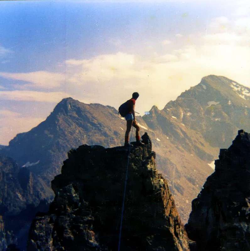
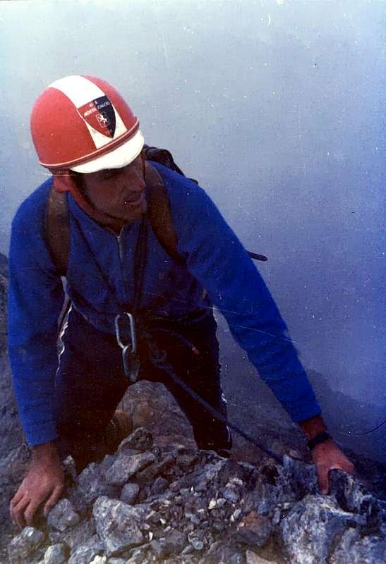
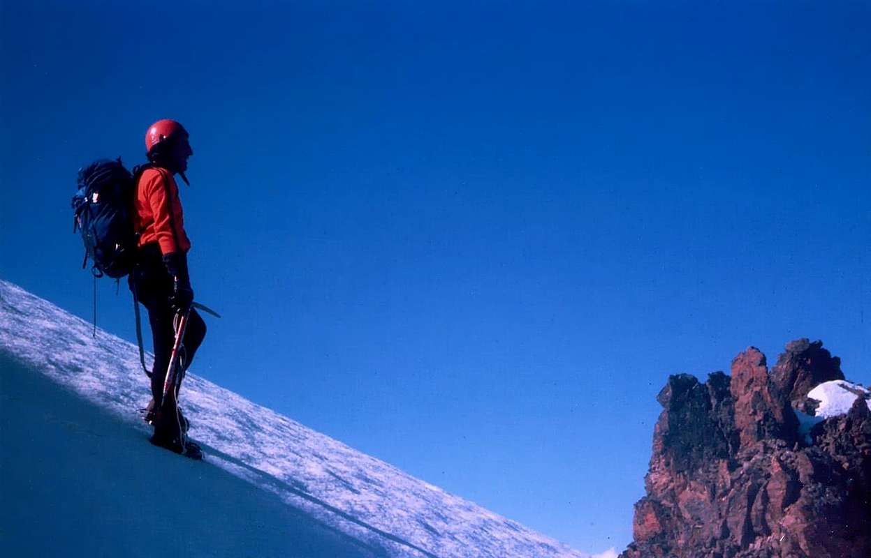
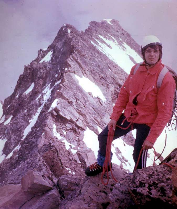
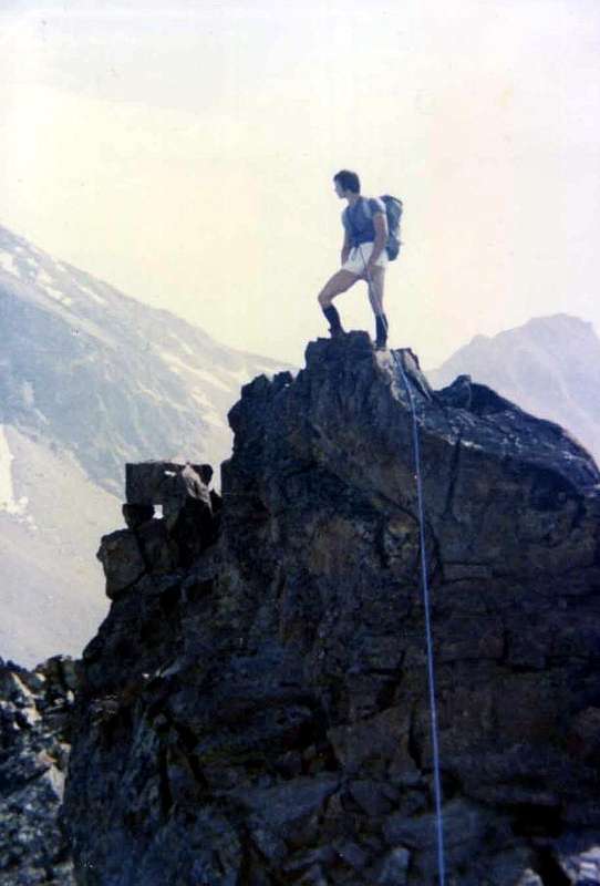
"On Top of Mont Ròss de Comboé (3.301m) in original West Ridge, August 1976", by Osw
7) - July 11th, 1977: Osvaldo Cardellina & Camillo Roberto Ferronato; first ascent? from Ròss Pass; in ascent in day from Pila, Comboé, Federigo Zullo Bivouac.
8) - June 30th, 1985: Alberto Sciardi, lone, in descent after North Wall, Central Couloir.
9) - Summer 1985 or 1986 or 1987: Carlo Lucianaz Charvensod, lone, in descent after the two N-NE Crest of "Becca" and Emilius.
10) - June 23 th, 1991: Osvaldo Cardellina, solo (from Ròss Pass); in ascent in day from Pila, Comboé, Federigo Zullo Bivouac.
11) - October 06th, 1996: Valpelline Mountain Guide Aldo Cambiolo & Stefano Mottini (from Ròss Pass); in ascent from Pila, Comboé, Federigo Zullo Bivouac.
12) - June 06th, 1999: Osvaldo Cardellina, alone, (after first ascent of West Wall of Mount Ròss of Comboé and subsequent traverse to Little Emilius & Saddle about 3.325/30 meters).
13) - July 24th, 1999: Courmayeur Mountain Guide Pellin with Andreas Meurer of Berlin and Ruggero Pellin.
NOTE: In addition, there are other routes but more partial and less and less long starting from West to East in relation to the routes opened on the Southern Side of Piccolo Emilius (3.342m) and on the just adjacent West-Southwestern, Southwestern and Southern Faces of Monte Emilius (from about 3.450 to 3.557/9 meters). Gradually the stretch of distance remains increasingly limited, logically, approaching the Summit. While the short parts after the exits out of the routes from the Northern Wall were not taken into consideration. Furthermore, it should be noted that this list cannot be considered perfectly complete, but has been drawn up on the basis of existing mountain and alpine literature and even by the various sport climbing books, as well as personal information, at times, sparingly and painstakingly obtained. We list some of them:
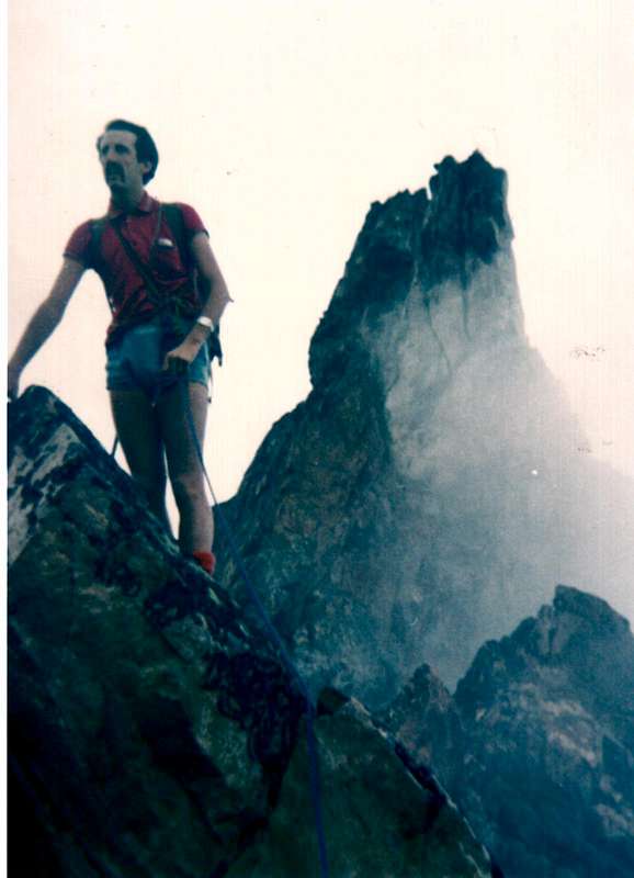
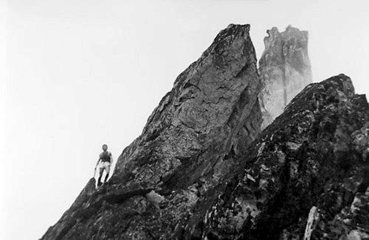
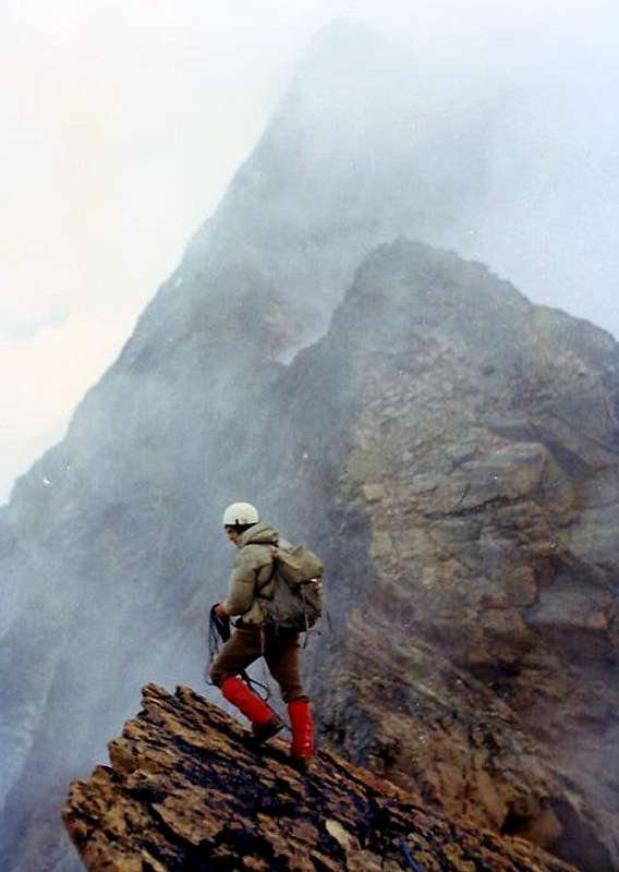
"On "Grey Jump" of West Ridge after Red Turrets (about 3.450/60m) August 1976", by Osw
NOTA:Inoltre esistono altri percorsi, ma più parziali e sempre meno lunghi partendo da Ovest verso Est in relazione alle vie aperte sul Versante Sud del Piccolo Emilius e su quelli Ovest-sudovest, Sudovest e Sud dell'Emilius. Via via il tratto di percorrenza rimane sempre più limitato, logicamente, avvicinandosi alla Vetta. Elenchiamone alcune:
14) - October 13th, 1968: Osvaldo Cardellina, solo, on Southern Face of Little Emilius and Western Crest; from Laks of Boulders near Lago Gelato.
15)- September 12th, 1911: Giovanni Battista Bozzino and Carlotta "Tina" Bozzino on S-SW Slope and W Arête: (Lake Gelato, SW Slope of "Little Saddle" 3325m and W Crest); in descent from Monte Emilius.
16) - Sepember 09th, 1875: Giuseppe Corona, Venanzio Defey and Charvensod Guide Grégoire Comé W-SW Slope ("Passaggio Corona"): from Pila, Lago Gelato.
17) - October 04th, 1992: First repetition: Osvaldo Cardellina, solo; (Oct 04th, 1992); in day from Pila, Chamolé, Arbolle, Boulders's Lochs; in descent by S-SE Crest to Gelato Lake.
18) - August 10th, 1994: Osvaldo Cardellina and Alessandro Cardellina on South "Rib of Red Turrets" (about 3.450/60m) and W Crest; in day, Pila, Lago Gelato.
19) - October 11th, 1986: Osvaldo Cardellina and Danilo Garzotto on W-SW "Great Pillar" and W Crest ("Direct Line to Grey Jump"); in day from Pila, Arbolle, Frozen Loch.
20) - June 19th, 1994: Osvaldo Cardellina, Roy Cardellina and Danilo Garzotto on S Slope (Direct Line on S-SW "Ribbing pear-shaped"); in day from Pila.
ADDITIONAL REMARKS: while the short parts after the exits out of various routes existing from the Northern Wall were not taken into consideration and yet, on the other hand, other but more complete and increasingly longer routes have been completed over a long period of time, starting from the Southwest and the Northwest (ie from the Becca di Nona(3.142m) and from the underlying Col Carrel (2.912m), however with ascents already partially mentioned above) towards the East in relation to the routes opened on the Southwestern Buttress climbing over the Trident de Comboé( (Northeast 3.083m, Central about 3.070/1m, Southwestern 3.057m), the homonymous hill, the Punte del Lago Gelato(3.113/5m) to join the previous routes with the Col Ròss (3.081m); in these cases the stretch of travel becomes more and more elongated, logically, moving away from the Summit. As already over mentioned, furthermore for an insistent desire for precision, it should be noted that this list cannot be considered perfectly complete, but has been drawn up on the basis of existing mountain and alpine literature as well as personal information, at times, sparingly and painstakingly obtained.
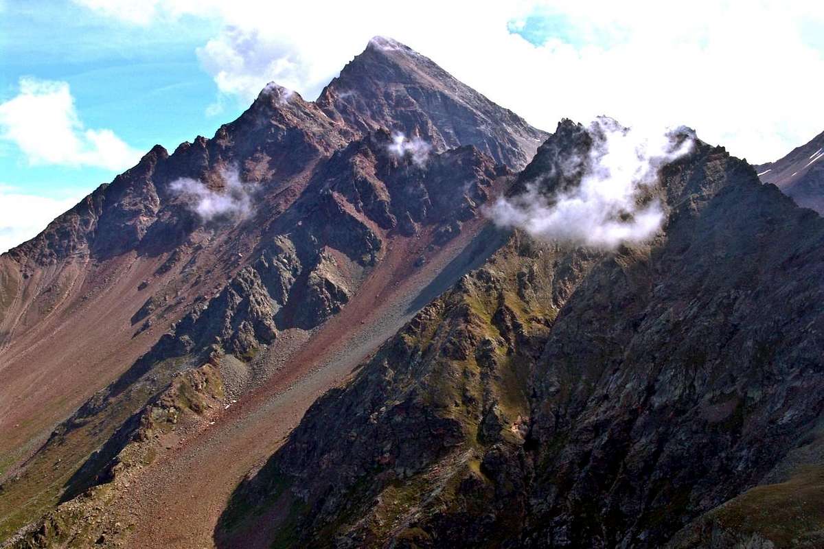
"On integral and complete S-SW Buttress preceding Western Ridge, August 1974", by Osw
ANNOTAZIONE SUPPLETTIVA:mentre non si sono presi in considerazione i brevi tratti di cresta percorsi dopo le salite a conclusione delle vie tracciate sulla Parete Nord, ed ancora, per contro, sono stati realizzati nell'arco di un lungo tempo, altri percorsi ma più completi e sempre più lunghi partendo da Sudovest e da Nordovest (cioé dalla Becca di Nona(3.142 m) e dal Col Carrel (2.912 m), peraltro con ascensioni già parzialmente sopra citate) verso Est in relazione alle vie aperte sul Contrafforte SO scavalcando il Trident de Comboé ( (Nordest 3.083 m, Centrale circa 3.070/1 m, Sudovest 3.057 m), l'omonimo colle, le Punte del Lago Gelato (3.113/5 m) per congiungersi con le vie precedenti al Col Ròss (3.081m); in questi casi il tratto di percorrenza diventa sempre più allungato, logicamente, allontandosi dalla Vetta. Inoltre é bene affermare, per volontà d'essere giustamente precisi, che questa elencazione non può considerarsi perfettamente completa, bensì é stata stilata in base alla tradizionale letteratura di montagna ed alpina e dai diversi libri di arrampicata sportiva esistenti, nonchè alle informazioni personali, a volte, sparutamente e faticosamente ottenute. Vediamole:
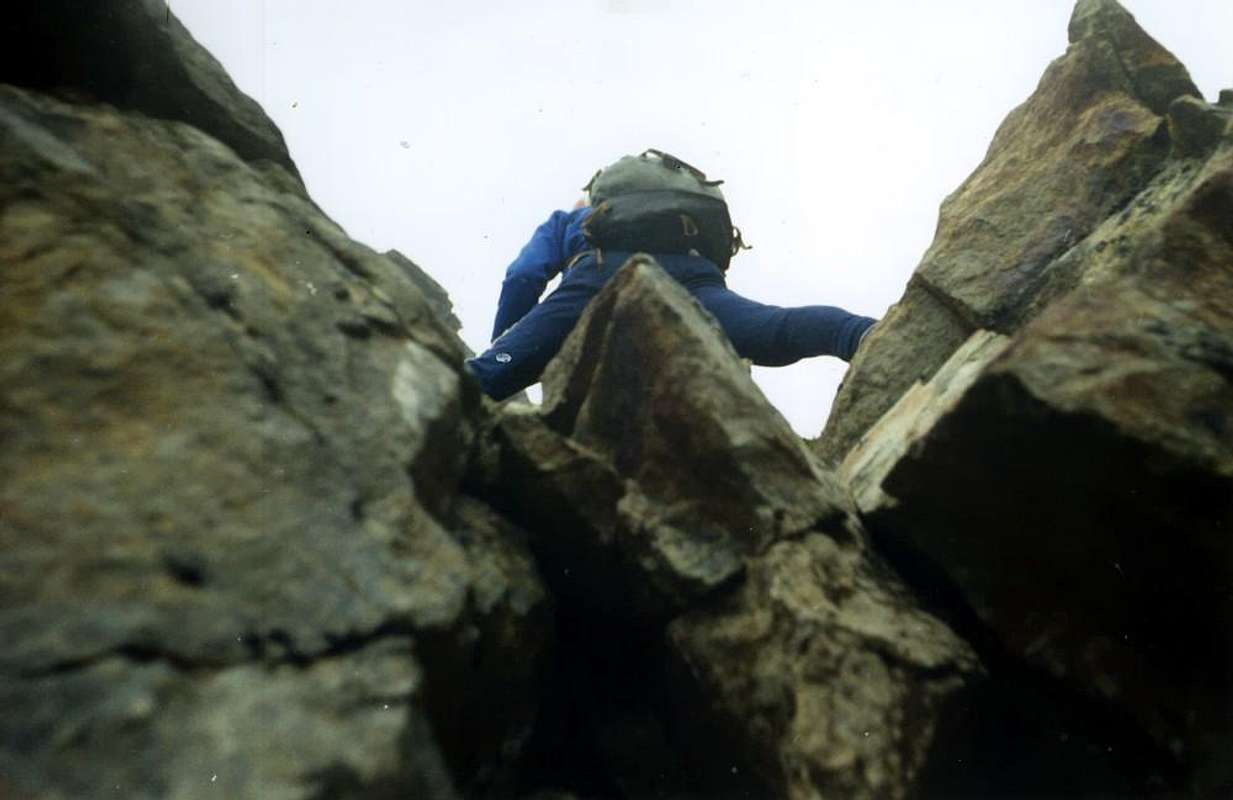
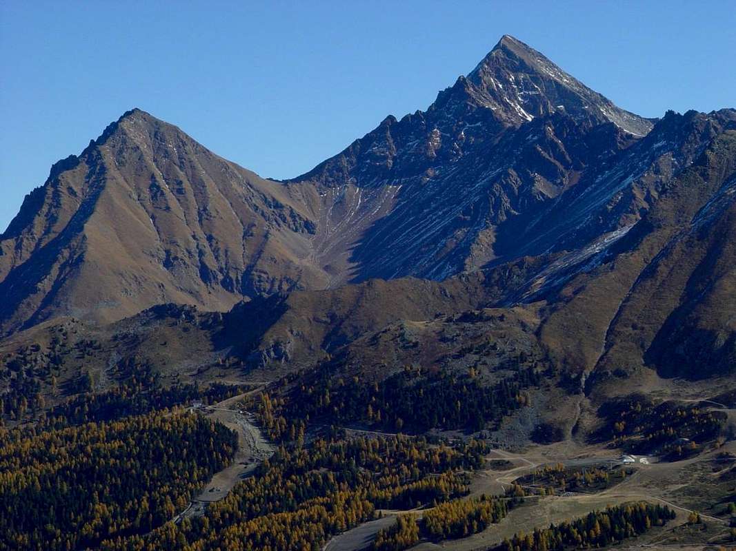
"On S-SW Buttress after Trident de Comboé (3.083m) and before the Western Ridge, August 1974", by Osw
21) - August 19th, 1974: Osvaldo Cardellina and Camillo Roberto Ferronato through SW Buttress and W Arête (Trident of Comboé-Punte del Lago Gelato-Mont Ròss de Comboé - Piccolo Emilius and W Ridge); in day from Pila and Arbole Vallon.
22) - July 11th, 1977: Osvaldo Cardellina and Camillo Roberto Ferronato along W Slope of Ròss Pass, S-SW Arête of Mont Ròss of Comboé and W Crest: Osvaldo Cardellina and Camillo Roberto Ferronato; in day from Pila, Chamolé Alpage, Colle Plan Fenetre, Comboé, Gros Scez.
23) - June 06th, 1999: Osvaldo Cardellina, solo on W Wall of Mont Ròss di Comboé and W Ridge; in day from Pila, Colle Plan Fenetre, Comboé, Plan Valé.
24) - September 16/7th, 1902: Abbot Joseph Maria Henry and Mountain Guide of Charvensod Grégoire Comé; NW Ridge (from Carrel Pass through Mont Ròss de Comboé - Piccolo Emilius and W Ridge in final part): in descent from M.Emilius and in ascent from Col Carrel strarting Comboé.
25) - September 20th, 1902: Felice Mondini and Emilio Questa with same route integrally in day, unaware of the previous climb starting directly from Aosta Town (!).
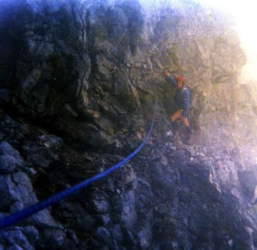
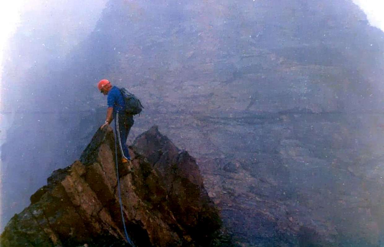
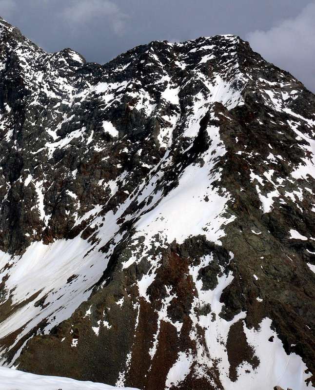
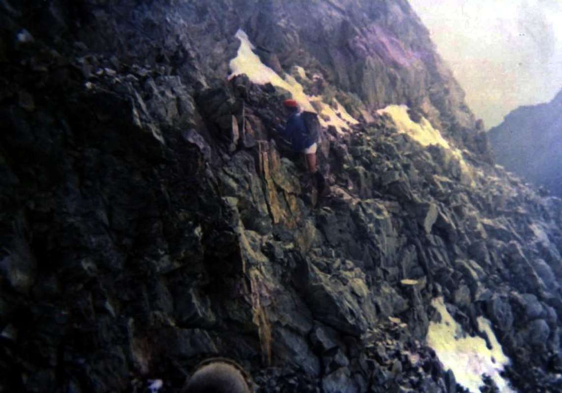
"Final part of West Ridge after two Red Turrets (about 3.450m) and in North Wall just below "Grey Jump", August 1974", by Camillo Roberto Ferronato
Getting There
BY CAR:
From TORINO, MILANO, etc: Motorway A5. Exit at Ivrea City, Quincinetto Common (PIEDMONT) or at Pont Saint Martin, Verrès, Chatillon, Nus Municipalities. By SS.26 from Ivrea Town towards: Quincinetto, Pont Saint Martin, Donnas, Hône-Bard, Arnad, Pont Bozet, Champorcher, Champdepraz, Fénis, Saint Marcel, Grand Brissogne, Pollein and Charvensod Municipalities.
Better departure: From Pont Suaz-Aosta (567m, 583m) before by the Cableway to Pila Resort (1.800m); after from this to Chamolé Lake and Hill 2.325m, 2.641m) with the Chair Lift towards Chamolé Upper Station (2.309m) and path. Also through the regional Road from Pont-Suaz towards Charvensod Commune, Pèroulaz, Les Fleurs and Pila.
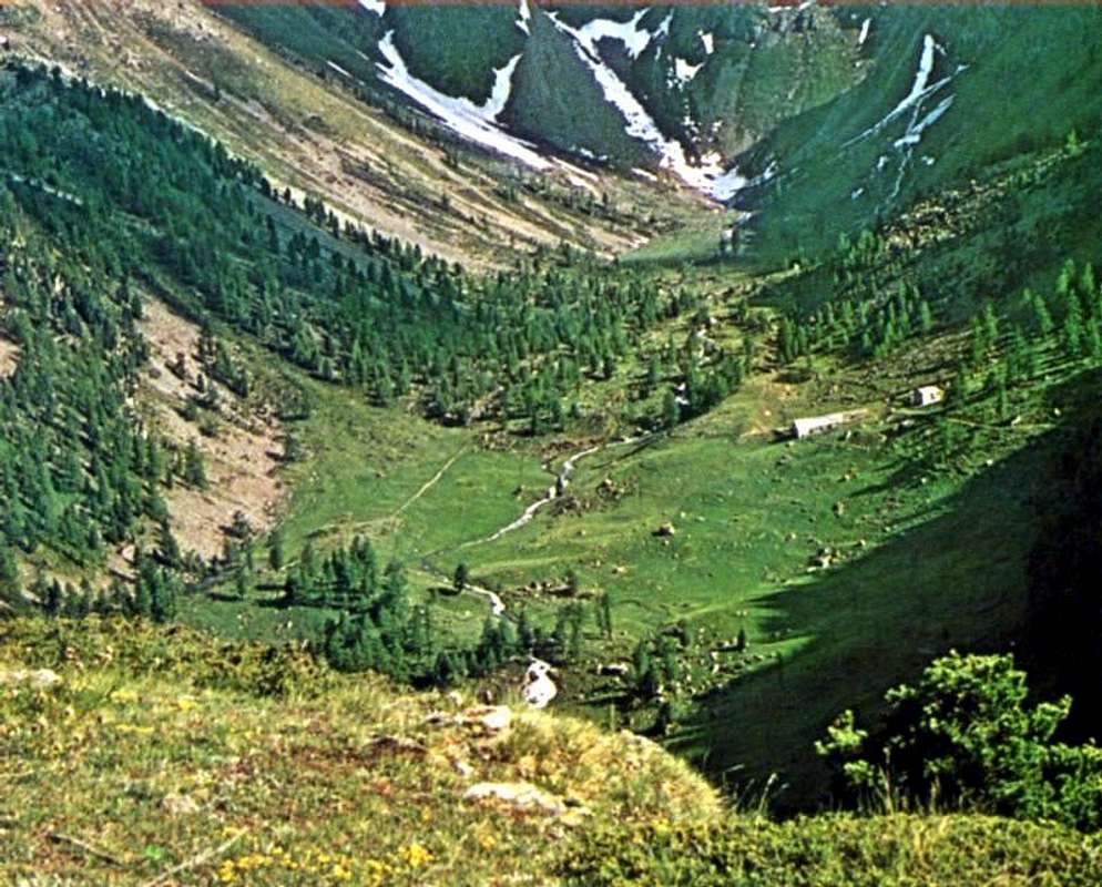
Other possibilities of entering partially in the route starting from: Pollein (575m; secondary road) or from Charvensod (746m; main road and connection) to Arpisson small Valley and Martsaouchy Damon (1.410m), through dirt farms road, and Arpisson Lower & Upper (1.951m, 2.010m) Alpages with ancient path. Federigo Zullo Bivouac through moraines on Western Arpisson Glacier. Charvensod to Dard-Comboé-Arbolle Gorge and small Valleys towards Ponteilles(1.697m) Alp & Waterfall, through dirt road, Comboé Alp & Saint Ours private Shelter (2.114m), through dirt road, and Arbolle Refuge(2.516m), nearby two Lakes (2.495m, 2.497m). Aymavilles(646m) to Western Pila Conca, through Main Road to Cogne Valley, alternative to Ozein/Turlin Dessus Hamlets and dirt road to Pila-Posse. Aymavilles towards Cogne Valley with Regional Main Road: Vieyes (1.132m) Fraction; continue to Silvenoire, Epinel and Crétaz Hamlets, Cogne(1.534m) Resort, through Main Road. From Cogne towards Gimillan Village(1.785m): from this in North to Grauson-Lussert Vallon and Frog, Corona, four Lussert Lakes also in Northwest towards Arpisson Alp Franco Nebbia Bivouac, through path in Upper Arpisson Vallon to Garin Hill (2.815m) with descent to Arbolle Refuge into the homonym Vallon.
From Arbolle Vallon final descent towards:from this to Chamolé Hill and Lake (2.641m, 2.325m), Chair Lift Chamolé Upper Station (2.309m), St. Grat Hermitage (1.773m), Pila-Resort (1.800m) and Pont Suaz-Aosta (567m, 583m).
From FRANCE: through the Mont Blanc Tunnel to Entrèves-crossroads to Vény/Ferret Valleys - Mountain Guides of Courmayeur - La Saxe Rock Gym - Courmayeur. By Little Saint Bernard Pass, closed since November until half May to La Thuile Valley - Pré Saint Didier - Courmayeur. It is not necessary to take Motorway A5: you can drive on SS.26, in the direction of AOSTA - IVREA - TURIN.
BY PLANE:
Aeroporto "Corrado Gex" Saint Christophe (Aosta).
Approaches
Above Comboé Vallon from Plan de Fenetre Hill or by variant through the fork near Grand Plan old Pasture reaching Plan Valè Tableland and Federigo Zullo Bivouac, by livioz & Osw
Approach A from Pila Resort through the two Replan Hill:(2.325m) on foot through the various paths n° 19/19A/19B, passing respectively to the Alpage of Chamolé (2.532m; fountain front pasture), also towards the Bois (Wood) Chanté, going up directly into a small vallon to Chamolé Lake (2.325m). Or to the same point by a Chairlift Chamolé from Pila, starting Bettères. From here the path to the Northeast n° 19 leading to the two Hills of Replan; dubbed the small and of the same name pointing to the left to reach the Northern Col and the small winding path always n° 19 off at Comboé (2.114m; private retreat of the Canons of Saint Orso; fountain nearby the alpage). From this directed to the South with the path and, after rounding a pond, cross the Torrent de Comboé following the path n° 16, which leads to Federigo Bivouac and Becca di Nona on Carrel Hill. Won a first slope quite steep and difficult, to achieve the Plan Valé (2.379m); come to the perimeter ruins of an old pasture, or even earlier neighbor the fork 2.329 meters from Grand Plan Alp, through to South or Southeast (depending on the route chosen) bringing near the Lago Gelato Tops and continue in diagonal route to the Southeast on steep gray moraine below Comboé Pass (3h'00). Variants:
a) - this trail connection, certainly more "comfortable", but that requires a larger circle first to the South and then returned Northeast, you can get to the bottom of the vallon, reaching the Grand Plan from Comboé (calculate half more hour).
b) - Of course you can make the approach starting from Federigo (2.907m) nearby the Col Carrel following the path downhill. In this case, you have the advantage of accommodation at a good altitude, bearing in mind that this choice should rise by Northeast Crest from Col Comboé (3.014m); after a descent of a few hundred metres from the camp, agrees to go Southwest and, passing below the West Face Mont Ròss remaining at a safe distance from it and doubling at the base the West-northwest Spur Punte Lago Gelato, climb through steep scree and gray moraines or through snowfields at the beginning of season. Avvicinamento A dal Comprensorio di Pila tramite i Colli di Replan:
Da Pila (nota località sciistica, raggiungibile da Aosta in auto, pullman con la Strada Regionale oppure tramite funivia), raggiungere il Lago di Chamolé (2.325 m, anche qui in seggiovia o a piedi tramite i vari sentieri n° 19/19A/19B) che passano rispettivamente per l'Alpe di Chamolé (2.532 m; fontana davanti all'alpeggio), oppure attraverso il Bois Chanté, salendo direttamente tramite un valloncello al Lago di Chamolé (2.325 m), ove si può giungere anche per mezzo della Seggiovia di Chamolé da Bettères. Da qui inizia verso Nordest il sentiero n° 19 che conduce ai due Colli di Replan (pannelli gialli); scartato quello Meridionale e doppiata l'omonima puntina a sinistra raggiungere il Colle Settentrionale e con il piccolo e tortuoso sentiero sempre n° 19 scendere a Comboé (2.114 m; rifugio privato dei Canonici di Sant'Orso; fontanile presso l'alpeggio). Da questo indirizzarsi a Meridione con il sentiero e, dopo aver doppiato un laghetto, attraversare su d'una passerella in legno il Torrent de Comboé seguendo il sentiero n° 16, adducente al Bivacco Federigo Zullo ed alla Becca di Nona. Dopo una passerella in legno sul medesimo e vinto un primo pendio alquanto ripido e faticoso in mezzo al bosco, raggiungere su terreno aperto il Plan di Valé; alle rovine perimetrali d'una antica alpe (2.379 m), oppure anche prima al bivio 2.329 metri, collegante l'Alpe Grand Plan, attraversare a Sud o Sudest (a seconda della via prescelta) portandosi verso le Punte del Lago Gelato ed il successivo ripido pendio morenico grigiastro sotto il Colle di Comboé (3h'00). Varianti:
a) - a questo sentiero di collegamento, sicuramente più "comodo", ma tale da richiedere un giro più largo dapprima verso Sud per poi rientrare verso Nordest, si può arrivare raggiungendo sul fondo del vallone il Grand Plan da Comboé (calcolare mezz'ora in più).
b) - Logicamente si può effettuare l'avvicinamento partendo dal Bivacco Federigo (2.907 m) al Colle Carrel seguendo il sentiero in discesa. In questo caso si ha il vantaggio del pernottamento ad una buona quota, tenendo presente che con questa scelta conviene salire tramite la Cresta Nordest dal Colle di Comboé (3.014 m); dopo una discesa d'un centinaio di metri dal bivacco, conviene dirigersi a Sudovest e, passando al di sotto della Parete Ovest del Mont Ròss de Comboé e doppiando lo Sperone Ovest delle Punte del Lago Gelato, risalire tramite ripide pietraie grigiastre oppure tramite nevati.
Approach B Arbolle Refuge: It is also possible to get off the Refuge Arbolle 2.516m with a small path n° 18 which runs to the North and, after reaching the Alp Grand Plan (2.158m; remains) through a narrow gorge, crossing the Torrent de Comboé with a diagonal from right to left in the middle of a heap of stones; From this point the path part of a diagonal n° 18 (yellow signals immediately to the East alp), which is directed towards Plan Valé and Federigo Zullo Camp. Take the same for about one-third to go up directly to the Comboé Trident first through bushes and trees and then through large rocks, or reach the Plan Valé and then navigate to the right or Southeast (EE; calculated for both 1h'30 1h'45).
Avvicinamento B dal Rifugio di Arbolle: Inoltre é possibile scendere dal Rifugio d'Arbolle 2.516 m con un piccolo sentiero n° 18 che gira verso Nord e, dopo aver raggiunto l'Alpe diroccata di Grand Plan (2.158 m) tramite una stretta gola, attraversa il Torrent de Comboé con un diagonale da destra verso sinistra in mezzo ad una pietraia; da questo punto parte un il sentiero diagonale n° 18 (cartello giallo subito ad Est) indirizzantesi verso Plan Valé ed il Bivacco Federigo. Percorrere il medesimo per circa un terzo per poi salire direttamente verso il Trident de Comboé dapprima tramite cespugli ed alberi e poi tramite grandi pietraie, oppure raggiungere il Plan Valé e poi traversare a Sudest (EE; calcolare per entrambi da 1h'30 a 1h'45).
Approach C from Pila through Plan Fenêtre Hill or from Ponteilles to the Vallon of Comboé: Pila catch up with the previous Approach A to Chamolé Pasture (2.532m); leaving right (South) detours to Lake Chamolé continue instead with the path n° 20 to the Northeast, that reached the junction in altitude 2.059meters with the private dirt road that goes from the Pasture and from the Hermitage of San Grato (1.787m), is entered in the woods, with almost flat and undulating path, arrive at the next fork at 2.140 meters, where the steep trail that climbs from the latter. With a final stroke on a slight slope and panorama you get to the Hill Plan Fenêtre (2.229m), hence with quiet down in the Southeast are within the Vallon and Alp Comboé (2.114m), where you reconnect with the previous A. Variants starting from below:
a)- this path you can get, as mentioned above, by means of a private dirt road that stretches from San Grato (1.787m), or by means of steep unnumbered mule-track that goes through the Black Forest Combatissière just Eastward.
b) - It is also possible to reach the Vallon Comboé from this of Dard, the one below it, with different starting points, reaches Alp Ponteilles and its beautiful waterfall (1.697m, around 1.640 meters); a path numbered 14D bastion dating this charming coming to Comboé Dessous (Low, 2.041m) at the entrance of the vallon immediately below and through the prairies to Alp Comboé (1h'00/1h'10 from Ponteilles Alpage).
Avvicinamento C da Pila attraverso il Col Plan Fenêtre o da Ponteilles al Vallone di Comboé: da Pila raggiungere con il precedente Avvicinamento A l'Alpe di Chamolé (2.532 m); lasciando a destra le deviazioni per il Lago di Chamolé, continuare invece verso Nordest con il sentiero n°20 che, raggiunto il bivio con la strada poderale che risale dall'Alpe e dall'Eremitaggio di San Grato in altitudine 2.059 metri, si immette nel bosco e, con percorso ondulatorio e quasi pianeggiante, arriva al successivo bivio 2.140 metri dove perviene la ripida mulattiera che sale da questi ultimi. Un ultimo tratto in falsopiano e panoramico porta al Colle Plan Fenêtre (2.229 m), donde con tranquilla discesa a Sudest si raggiungono il Vallone e l'Alpe di Comboé (2.114 m), dove ci si riconnette col precedente A. Varianti partendo da più in basso:
a) - a questo sentiero si può arrivare, come detto sopra, tramite una strada poderale che parte da San Grato (1.773 m), oppure per mezzo della ripida mulattiera non numerata che sale attraverso la Foresta Nera di Combatissière appena più ad Oriente,
b) - Inoltre é possibile raggiungere il Vallone di Comboé da quello sottostante del Dard che, con vari punti di partenza, perviene all'Alpe di Ponteilles ed alla sua bella cascata (1.697 m, 1.640 metri circa); un sentiero n° 14D risale questo spalto suggestivo arrivando al Comboé Dessous (2.041 m) all'ingresso del vallone e subito appresso per praterie all'Alpe di Comboé (1h'00/1h'10 da Ponteilles).
Routes Description
"On ancient West Ridge after Mont Ròss de Comboé (3.301m) and preceding Little Emilius (3.342m) , on August1976", by Osw
A) - From Federigo Zullo Bivouac (2.907m) nearby the Col Carrel (2.912m), along the Northwestern Crest of Mont Ròss de Comboè (3.301m), Piccolo Emilius (3.342), two Red Turrets (3.450/60 meters around)and "Grey Jump" on final Western Ridge. From the bivouac go up the first easy stretch of the ridge, consisting of broken rocks that form some small ramps with also suspended debris alternating with small cracks-chimneys of short length, remaining on the thread of the corner or just below to the North-Northeast and reaching the "Red Tower"or "Red Tooth" at an altitude of 3.150 meters I.G.M. (up to now passages at I°+ at II°+ and, remaining on the edge of the ridge, also short sections of III°-). Directly overcome the climb of the same (once almost always going around to the left or North, or to the South as for the first climbers of September 1902) you descend the next vertical jump (III°+, little or, better, very scarce possibility of insurance) leaning just on the left of the edge of the ridge and reaching a very narrow notch (below the current Tibetan bridge) where it is difficult to stay in two. The subsequent ascent to the ridge is steep, but not difficult (from II° to II°+). The subsequent ascent to the ridge is steep, but not difficult (from II° to II°+). Beyond, you climb over two other elevations followed by as many collars more easily than expected (I°+, II°-) and then continue more linearly overcoming a short grayish ramp. After a tiny pinnacle followed by a terrace, the ridge softens on a slope heading further SE as well as towards the West Face of Mont Ròss de Comboé. It then resumes rising with progressive steepness overcoming three consecutive asperities, the last of which forms a "Capuchin" that folds back on itself in the act of prayer (at least so they had identified in 1902 the Abbot Joseph Maria Henry and the Mountain Guide Grégoire Comé. As it is that, superstitiously having felt observed and therefore with a sign of doom, they had rounded on the right through and into a rocky gully). Easily overcome the "impasse", the last stretch easily leads to the Summit of Mont Ròss de Comboé (3.296 or 3.301 meters, depending on the maps; 1h.30 'from the Federigo Bivouac). Here the crest, the watershed (no longer between the Comboé Vallon with that of Arpisson, but with the second divided by that of Arbole or Arbolle) becomes pseudo-rectilinear and, after passing two small humps, descends to a small collar that precedes the Piccolo or Little Emilius (3.342m); this stretch is almost "walkable" on smooth slabs slightly inclined to the South (Arbole's Slope), but requires attention in case of snow or ice. Climbed over the same, you arrive at a second and wider saddle (where the Via dell'Astosto 1897 exits from the North Wall, the first ascent from the Arpisson of the entire wall) with a slight descent and then resumes climbing in the direction of one dark wall followed by a small point shapes almost a pin (II°-). Two other similar elevations (II°-) reach a third one that precedes the first two "Red Towers" (exposed and delicate route, on the crestline from III° to IV-/IV°+, bypassable to the South (II°+), but not in the North on the face as done in August 1974 (due to fatigue) on more dangerous than difficult terrain (III°/III°+, exposed and on very fragile rocks almost at the end of the Northern "Canalone" or Couloir of the right; see photo). The third turret is less evident and also easier to climb, as well as positioned above the left orographic edge (West) of the same couloir. A short crest like a comma (be careful if it is covered in snow) leads to the base of the "Salto Grigio" or "Grey rocky Jump", a passage on fairly solid almost vertical greyish rock of about twenty meters and at plumb of the gully itself. Very exposed (III° and III°+ if climbed on the wire). Here too avoid the dasngerous ramp that climbs West / East diagonally up to the Northern Wall). Four other tiny elevations lead quite easily (from I°+ to II°-) to a rounded collar, positioned vertically on the Central Gully of the North Wall, as well as to the exit out from the Southern little Gully of the opposite side. The last stretch, overlooking the Eastern side of the North Wall (from the Eastern Pillar of 1926, 1927 to the Direct Routes traced on 1980, 1984) is more linear and leads easily to the Top (2h'00; total 3h'30/4h'00 from Col Carrel; 6h'30/7h'00 Pila Resort through the Plan de Fenêtre Hill (2.221m)).
WARNING: This report concerns a complete, integral route (August 1976) starting from Federigo Zullo bivouac at Colle Carrel (2.907, 2.912 meters) As well as the subsequent relations B and C starting from Col Ròss or by Arbole Shelter along Southwestern Buttress. There are also other routes, but more partial and less and less long, starting from the West or from the South-Southwest towards the East in relation to the routes opened on the South Slope of Piccolo Emilius and on those West-Southwest, Southwest and South of Emilius. In these cases the route logically becomes more and more limited as you approach the Top.
B) - From Gros Scez or even said as le Grand Sax (2.526m), along the Western Slope of Col Ròss (3.091m), by Southern Crest of the same and preceding via. Reached Vallone di Comboé via Colle Plan de Fenêtre (2.221m), or from the Chairlift Station of Lake Chamolé (2.309/11 meters, 2.325 meters) by means of one of the two adjacent Colli di Replan (Southern 2.347m, Northern 2.366m) and again also downhill arriving from the Arbolle or Arbole Refuge (2.516 m) through the Arbole / Comboé steep gorge and ascent with path n° 16 diagonally from the now dilapidated Alpe of the Grand Plan (2.158m) to tableland of Plan Valé (2.379) , you reach the Gros Scez boulder. Just before the junction between the two paths for Becca di Nona (Northwest) and Col Carrel (Northeast), deviate sharply to the left (East) on the steep moraine (at the beginning of the season there are snowfields as a remnant of late spring avalanches) going up the same towards the Col Ròss above (3.091m).
ATTENTION: the passage takes place on the left or Northern hill, being the same double, even if the one on the right is slightly lower. The climb begins by overcoming half a dozen of tiny elevations and asperities which, in a linear way, lead to a first rounded hump; descending to the narrow little notch below, you pass a second smaller one beyond which the ridge begins to rise again in a linear fashion formed by broken rocks, debris and stacked blocks (I°+/II°-), which form three small asperities. Then it rears up more and, passing in succession three black plates (II°+ if traveled on the wire) leads to the Summit which can be reached on the right (East) of the little man or rocky cairn. If covered entirely on the edge of the ridge, the difficulties are slightly increased, while the route in the presence of snow or, worse, ice, is much more demanding.
NOTICE: from this season (2001) also thie Southwestern Crest has been equipped as a Via Ferrata, in order to allow the ascent also starting from the Rifugio di Arbole, into the homonym Vallon,and reaching Col Ròss through Eastern Slope of the same.
C) - From Arbole or Arbolle Refuge (2.516 m), through the entire and integral South-southwestern Buttress, bypassing the Trident de Comboé ( (Northeast 3.083 meters, Central about 3.070/1 meters, Southwest 3.057 meters) Punte del Lago Gelato (3.113/15m), Col Ròss (3.091m) up to the Mont Ròss de Comboè (3.301m) and similar routes in terminal part.
A) - Dal Bivacco Federigo Zullo (2.907 m) presso il Col Carrel (2.912 m), lungo la Cresta Nordovest del Mont Ròss de Comboè (3.301 m), Piccolo Emilius (3.342 m), le due Torri Rosse (3.450/60 metri circa)ed il "Salto Grigio" nella parte finale della Cresta Occidentale. Dal bivacco risalire il primo facile tratto di cresta, costituito da rocce rotte che formano alcune piccole rampe con anche detriti sospesi alternate a piccole spaccature-camini di breve lunghezza, restando sul filo od appena al di sotto a Nord-nordest raggiungendo la "Torre Rossa" a quota 3.150 metri (fino a qui passaggi al I°+ al II°+ e, restando sul filo di cresta, anche brevi tratti di III°-). Superata direttamente la salita della medesima (una volta quasi sempre aggirando sulla sinistra o Nord, oppure a Sud come per i primi salitori del Settembre 1902) si scende il successivo salto verticale (III°+, scarsa possibilità di assicurazione) appoggiandosi appena sulla sinistra del filo di cresta e raggiungendo uno strettissimo intaglio (al di sotto dell'attuale ponte tibetano) dove si fa fatica a restare in due. La successiva risalita in cresta é ripida, ma non difficile (dal II° al II°+). Oltre, si scavalcano altre due elevazioni seguite da altrettanti colletti più facilmente del previsto (I°+, II°-) per poi proseguire più linearmente superando una breve rampa grigiastra. Dopo un minuscolo pinnacolo al quale fa seguito una terrazza, la cresta si addolcisce in pendenza dirigendosi più a SE nonché verso la Parete Ovest del Mont Ròss de Comboé. Quindi riprende a salire con progressiva ripidezza superando tre risalti consecutivi, l'ultimo dei quali forma un "Cappuccino" e ripiegato su se stesso nell'atto di preghiera (almeno così l'avevano individuato nel 1902 l'Abate Joseph Maria Henry e la Guida Grégoire Comé che, superstiziosamente essendosi sentiti osservati e quindi con segno di sventura, lo avevano doppiato sulla destra tramite un canalino roccioso). Superato agevolmente lo "impasse", l'ultimo tratto conduce facilmente alla Sommità del Mont Ròss de Comboé (3.296 oppure 3.301 metri, a seconda delle mappe; 1h.30' dal Bivacco Federigo). Qui la cresta, spartiacque (non più tra il Vallone di Comboé con quello di Arpisson, bensì col secondo diviso da quello di Arbole od Arbolle) diventa pseudo-rettilinea e, superate due gobbe di scarsa entità, scende ad un collare che precede il Piccolo Emilius (3.342 m); questo tratto é pressocché "camminabile" su placche lisce scarsamente incllinate a Sud, ma richiede attenzione in caso di neve oppure ghiaccio. Scavalcato lo stesso, si arriva ad una seconda e più larga sella (dove dalla Parete Nord esce la Via dell'agosto 1897, prima salita dall'Arpisson dell'intera muraglia) con una discesa appena accennata per poi riprendere a salire di direzione di uno scuro muretto seguito da una puntina che é quasi uno spillo (II°-). Altre due elevazioni similari (II°-) ne raggiungono una terza che precede le prime due "Torri Rosse" (esposto e delicato, sul filo dal III° al IV°-/IV°+, aggirabile a Sud (II°+), ma non a Nord sulla parete come fatto nell'Agosto 1974 (per stanchezza) su terreno più pericoloso che difficile (III°/III°+, esposto e su rocce fragilissime quasi al termine del Canalone di destra della Nord; vedi foto). La terza torretta é meno evidente ed anche di salita più semplice, nonché posizionata al di sopra dell'orlo sinistro orografico (Ovest) del medesimo. Una breve crestina a mò di virgola (attenzione se innevata) conduce alla base del "Salto Grigio", passaggio su abbastanza solida roccia grigiastra quasi verticale di una ventina di metri e proprio a picco del canalone medesimo (molto esposto, III° e III°+ se percorso sul filo, anche qui evitare la rampa che sale in diagonale sulla Parete Nord ). Altre quattro minuscole elevazioni conducono abbastanza facilmente (dal I°+ al II°-) ad un tondeggiante collare, posizionato in verticale sul Canalone Centrale della Parete Nord, nonché all'uscita dal Canalino Sud dell'opposto versante. L'ultimo tratto, sul lato Orientale della Parete Nord (dal Pilastro Orientale del 1926 e 27 alle Vie Dirette del 1980 ed 84) é più lineare e conduce agevolmente alla Vetta (2h'00; totale 3h'30/4h'00 dal Col Carrel; 6h'30/7h'00 da Pila tramite il Colle Plan de Fenêtre (2.221 m)).
AVVERTENZA: Questa relazione concerne un percorso completo ed integrale (Agosto 1976) partendo dal Bivacco Federigo Zullo presso il Colle Carrel (2.907, 2.912 metri). Così come le successive relazioni B nonché C iniziando dal Col Ròss oppure dal Rifugio d'Arbole con percorrenza del Contrafforte Sudovest. Esistono altri percorsi, ma più parziali e sempre meno lunghi partendo da Ovest o da Sud-sudovest verso Est in relazione alle vie aperte sul Versante Sud del Piccolo Emilius e su quelli Ovest-sudovest, Sudovest e Sud dell'Emilius. In questi casi il tragitto diventa sempre più limitato con l' avvicinamento alla Cima.
"Crossing with snow and ice along Western Ridge between Mont Ròss de Comboé (3.301m) and Little Emilius (3.342m) , on July1977", by Camillo Roberto Ferronato
B) - Dal bivio presso il Gros Scez (2.526 m) oppure detto le Grand Sax, lungo il Versante Ovest del Col Ròss (3.081 m) e tramite la Cresta Sud del medesimo per concludere con la precedente via. Raggiunto il Vallone di Comboé tramite il Colle Plan de Fenêtre (2.221 m), oppure dalla Stazione della Seggiovia del Lago di Chamolé (2.309/11metri, 2.325 metri) per mezzo di uno dei due attigui Colli di Replan (Sud 2.347 m, Nord 2.366 m) ed ancora anche in discesa arfrivando dal Rifugio di Arbolle od Arbole (2.516 m) tramite la gola Arbole/Comboé e risalita con il sentiero n° 16 in diagonale dall'Alpe ormai diroccata del Grand Plan (2.158 m) fino al Plan Valé (2.379 m), si raggiunge, appunto, il masso del Gros Scez. Appena prima del bivio tra i due sentieri per la Becca di Nona (Nordovest) ed il Col Carrel (Nordest), deviare decisamente verso sinistra (Est) sulla ripida morena (in inizio di stagione lingue di nevai a residuo delle valanghe della tarda primavera) risalendo la medesima in direzione del soprastante Col Ròss (3.091 m).
ATTENZIONE: il passaggio avviene sul colle di sinistra o Nord, essendo il medesimo duplice, anche se quello sulla destra risulta leggermente più basso. Dal colle svoltare a sinistra (Nord) andando ad afferrare la Cresta Meridionale (SO) del Mont Ròss de Comboé, che si risale facilmente in una quarantina di minuti. La salita inizia superando una mezza dozzina di minuscole asperità che, in modo lineare, conducono ad una prima gobba arrotondata; scesi allo stretto intaglietto sottostante, si supera una seconda più piccola oltre la quale la cresta riprende a salire in modo lineare formata da rocce rotte, detriti e blocchi accatastati (I°+/II°-), che formano tre piccole asperità. Quindi la medesima si impenna maggiormente e, superando in successione tre placche nerasstre (II°+ se percorse sul filo) conduce alla Sommità che si raggiunge sulla destra (Est) dell'ometto. Se integralmente percorsa sul filo di cresta leggermente si innalzano le difficoltà, mentre invece ben più impegnativo risulta il percorso in presenza di neve o, peggio, con ghiaccio.
AVVISO:dalla stagione 2001 anche questa cresta é stata attrezzata come Via Ferrata, onde consentire l'ascensione anche partendo dal Rifugio di Arbole e raggiungendo il Col Ròss dal Versante Orientale dello stesso.
C) - Dal Rifugio d''Arbole od Arbolle (2.516 m), tramite l'intero ed integrale Contrafforte Sudovest, scavalcando il Trident de Comboé ( (Nordest 3.083 m, Centrale circa 3.070/1 m, Sudovest 3.057 m), le Punte del Lago Gelato (3.113/5 m), il Col Ròss (3.091 m) e raggiungendo il Mont Ròss de Comboè (3.301 m), nonché similari vie nella parte terminale.
"On terminal part of West Ridge just below the two Red Turrets (about 3.450m), August 1974", by Camillo Roberto Ferronato
Essential Gear (DIFFICULTIES & EQUIPMENT)
DIFFICULTIESFrom F+/PD/PD to AD-/AD for the Route A (from Col Carrel). From F+ to AD-/AD for the Route B (from Col Ròss).
Da F+/ PD-/PD ad AD-/AD per la Via A (dal Col Carrel). Da F+/PD- a AD-/AD per la Via B (dal Col Ròss).
EQUIPMENT For Hiking, better with rope, carabiners and some lanyard for the Routes A & B. In case of snow and ice also rope, ice ax and crampons.
Da Escursionismo, meglio con corda, moschettoni e qualche cordino sia per la Via A che per la Via B. In caso di neve e ghiaccio anche corda, piccozza e ramponi.
Mountain Conditions
Meteo: you can find all the needed informations at the official site of the Valle d'Aosta Region:
"Guida del Monte Emilius", di Osvaldo Cardellina Editore in collaborazione con il Club Alpino Italiano Sezione di Aosta, Dicembre 1978.
"Guida dei Monti d'Italia – Emilius Rosa dei Banchi Parco del Mont Avic" di Giulio Berutto e Lino Fornelli - Club Alpino Italiano/Touring Club Italiano, Marzo 2005.
"Guida delle Alpi Occidentali" di Giovanni Bobba e Luigi Vaccarone C.A.I. Sezione di Torino Volume II (parte II), 25 Maggio 1896.
"80 itinerari di Escursionismo Alpinismo e Sci Alpinismo in Valle d'Aosta", di Osvaldo Cardellina, Ed. Musumeci, Giugno 1977 (in Italian); seconda Ed. Luglio 1981; terza Ed. Luglio 1984; (in French), prima Ed. Febbraio 1978; seconda Ed. Marzo 1980.
"Diari Alpinistici" di Osvaldo Cardellina e Indice Generale accompagnato da Schedario Relazioni Ascensioni 1964-2019 (inediti).
Kompass "Gran Paradiso Valle d'Aosta Sentieri e Rifugi" Carta turistica 1:50.000.
L'Escursionista "Conca di Aosta-Pila-Monte Emilius" Carta dei sentieri (n° 4) 1:25.000.
Hapax "Les Sentiers Comunità Montana Monte Emilius", Luglio 2000 1:25.000.
Enrico Editore Ivrea-Aosta "Gruppo del Gran Paradiso" 1:50.000.
I.G.C. Istituto Geografico Centrale, Torino "Carta delle Passeggiate ed Escursioni in V.D.A. Conca di Pila-Gressan, 1:20.000.
External Links
More about Emilius Another description with 40 shots, 6 panoramas and a "handmade" map, about Emilius.


 913 Hits
 79.04% Score
 10 Votes