
|
|
Route |
|---|---|
|
|
Hiking |
|
|
Spring, Summer, Fall, Winter |
|
|
EASY |
|
|
Hochsimmern to Schloss Buerresheim
  |
 |
 Hochsimmern-hut
 Tower on Hochsimmern
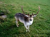 A young deer
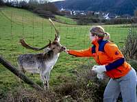 Feeding the deer
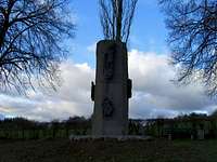 Memorial stone "Holy Johann"
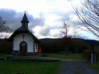 Holy Barbara Chapel
 Way to Hammesmühle
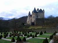 Schloss Buerresheim
 Way back to the parking
 Typical view of Eifel
 Hochstein
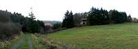 Forester's lodge
The highest point of the Eastern-Eifel is Hochsimmern (587m) near Ettringen. From top you have a fantastic view to the Rhine-valley, the eastern part of the Eifel and the cities west of Koblenz. On top of Hochsimmern is a look-out-tower and a transmitting station. The old castle "Schloss Buerresheim" is located southwest of Hochsimmern. This castle was built near Sankt Johann in the Nette-valley by Eberhard und Mettfried de Burgenesem in the 12th century. You can combine these two little highlights to a roundtrip. It takes ca. 3 hours and 400mH. It is also possible to do this trip by mountain-bike.
Getting there
You can start the roundtrip at the parking of Hochsimmern-hut (or in Sankt Johann).
STARTING POINT PARKING HOCHSIMMERN-HUT:
From North (Cologne/Bonn) on highway A61 to the exit #34 "Mendig". Follow the signs to Bell. Then continue towards Ettringen. Short before Ettringen at the junction to "Weibern" leads a farm-track to the parking of Hochsimmern-hut. (Follow the signs "Frei bis Waldparkplatz"). The parking is on the right-handed-side.
From South (Mannheim - A61 - A48) and West (Trier) on A48 to Exit #6 "Mayen". Continue on B262 towards Mayen and Ettringen. Behind Ettringen drive to the junction to "Weibern". There leads a farm-track to the parking of Hochsimmern-hut. (Follow the signs "Frei bis Waldparkplatz"). The parking is on the right-handed-side.
Route-Description
Parking - Hochsimmern-hut: You start the route at the parking of Hochsimmern-hut. You go on the farm-track in 3-5 minutes up to Hochsimmern-hut.
Hochsimmern-hut - Hochsimmern: At Hochsimmern-hut you follow the track on the right side and the signs "Aussichtsturm" to Hochsimmern. The tower is opened during the whole year. From top you have a fantastic view to the eastern part of the Eifel.
Hochsimmern - Sankt Johann: Behind the tower (North-side) leads a track to the north, then it turns to the south and heads towards Sankt Johann. After a while the track will be asphalted. Short be before Sankt Johann you arrive at a outdoor enclosure with deers on the left side. You could feed the deers, they are very gentle. After the outdoor enclosure you arrive in Sankt Johann. At the beginninng of the town is a memorial stone for the Holy Johann. At the memorial stone continue the street to the right.
Sankt Johann - Schloss Buerresheim: Follow the street from the memorial stone to the center of Sankt Johann until you arrive at "Hauptstraße". Now, turn right and follow "Hauptstraße" towards Schloss Buerresheim. At the end of the town is a little chapel on the left side. The chapel was built for the soldiers of the First World War and is dedicated to the Holy Barbara. Now, you follow the street to the West until you arrive at a gap in the guardrail on the left side. There is a sign "Hammesmühle". Follow the steep path through the forest down to Hammesmühle, an old historic restaurant. Cross the street and follow the street to the right towards Schloss Buerresheim in a few minutes. (If you do this trip by mountain-bike you have to follow the street from the chapel to Schloss Buerresheim, don´t drive through the forest down to Hammesmühle).
Schloss Buerresheim - Parking: From Schloss Buerresheim you return to Hammesmühle and ascend to the gap in the guardrail. Now turn right and walk in direction of Sankt Johann. At the point where the street leaves
the forest you have to turn left on a path into the forest. After a while you arrive at a bench where you have the last view to Schloss Buerresheim. At the bench follow the left track #6 to a hut with a fire-place. Behind the hut the track goes up to a junction. Follow the left track with the barrier. This path leads to an old forester's lodge and the farm-track at the parking of Hochsimmern-hut. On the way through the forest you arrive at two junctions, chose the right path in each case.
Links
Information about Schloss Buerresheim: Tickets, opening hours etc.
information about Sankt Johann
Information about Restaurant Hammesmühle
Hiking Guide Eifel, including this route.