
-
 4356 Hits
-
 0% Score
-
 0 Votes
PLEASE DO NOT VOTE

PLEASE DO NOT VOTE.
THIS PAGE IS FOR
FORMATTING PURPOSES ONLY.
Headers
25%, size = 1
50%, size = 2
75%, size = 4
100%, size = 6
One way is to use the font tag's color attribute -
Code:
summitpost link text
Marquee and Line
Photos in Tables
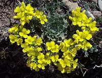
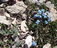
![Twinpod or Physaria]()
![Mountain Douglasia]() Mountain Douglasia
Mountain Douglasia![Alpine Forget-Me-Nots]() Alpine Forget-Me-Not
Alpine Forget-Me-Not
![Arrowleaf Balsamroot]() Arrowleaf Balsamroot
Arrowleaf Balsamroot![Rocky Mountain Phlox]() Rocky Mountain Phlox
Rocky Mountain Phlox![Tapered Leaved Beardtongue]() Tapered Leaved Beardtongue
Tapered Leaved Beardtongue
Script in table
To visit Glacier National Park is to enter a place where Heaven touches Earth affording brief glimpses into the Wonders of Creation.
Photos w/o Border
Reynolds Mountain

Side by Side
Differing Views of Glacier National Park


Landscape
Heaven's Peak East Slope Route

Ceded Strip
The “Ceded Strip”.
The park was established in 1910.
Original Size
Glacier Flora

Photos in Tables


Frequently Used Links and Text
Place Names of Glacier National Park by Jack Holterman
A Climber’s Guide to Glacier National Park; J. Gordon Edwards
CLIMB REGISTRATION: You do not have to register for day climbs in Glacier National Park but it is recommended. Backcountry travel regulations can be found at Backcountry Travel. There is also information from the Park Service on Mountain Climbing in Glacier. Registration for climbing Mount Gould can be accomplished at the Logan Pass Visitor’s Center.
As with all hiking and climbing in Glacier National Park use caution and practice good manners with the wildlife. You are in bear country. Carry bear deterrent spray, don’t hike alone and make some noise. For more information please go to the Park's website for Bear Information. The U.S. Forest Service also has helpful information on Grizzly Bear Management.
Vehicle single entry fee for Glacier National Park is $25.00 for 7 Days, $12.00 per person for single hiker, motor biker or bicyclist. An "America The Beautiful Federal Lands Recreational Pass" for goes for $80.00 which gives entrance to all National Parks, National Forests, BLM, US Fish & Wildlife, and Bureau of Reclamation sites for one year from date of purchase. See Plan Your Visit for other information regarding all of the National Park entrance fee information.
If you are planning on visiting Waterton Park make sure you have a passport to simplify crossing the border.
Glacier National Park’s Lincoln Peak is located in Northwest Montana. The locals all say, "Have a nice VISIT in Montana". While you are visiting check out other things to do at Things To Do In The Flathead Valley.
Montana is a long way from most places. That’s why many of us live here.
It is possible to get here by:
By Air: Glacier International Airport serves as the air hub for northwestern Montana. Horizon, Delta Connection and Northwest Airlines service this area.
By Bus: Northwest Montana is served by bus service.
By Rail: Amtrak arrives daily from Minneapolis or Seattle stops in East Glacier, Essex, West Glacier and Whitefish.
By Road: The major highways serving northwest Montana include U.S. Highway 2 running east and west and
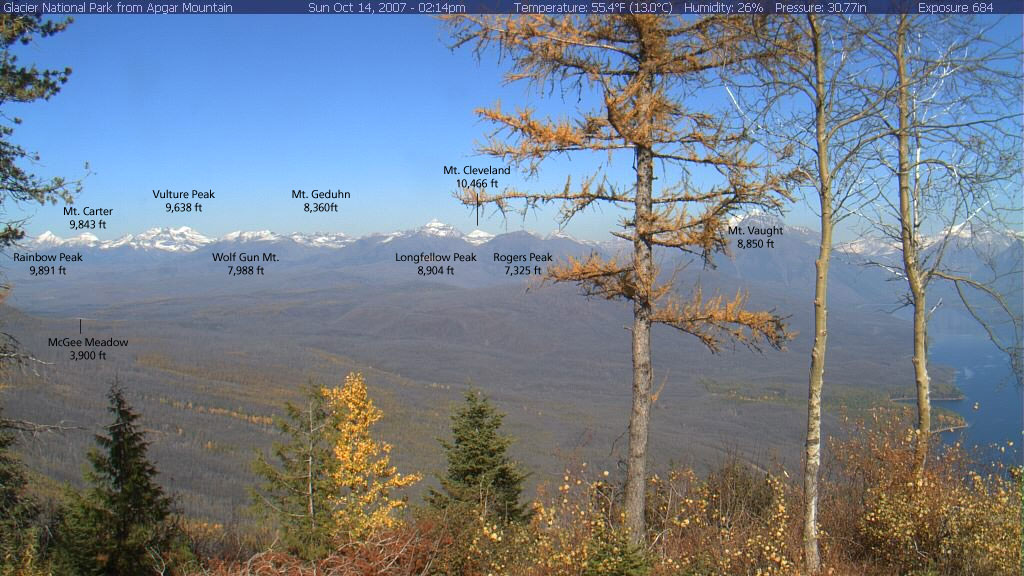
Apgar Cam with Peaks Identified
Apgar Webcam Page
Glacier National Park in Pictures
Glacier Mountaineering Society
Logan Pass Trails
Visit Montana running north to south are U. S. Highway 93 and Montana Highway 83. Glacier National Park is located 160 miles north of Interstate 90 which runs through the southwestern portion of Montana.
Rental cars can be secured in the Flathead Valley at and near Glacier International Airport. See Car Rentals in Montana.
In Montana it is said “If you don't like the weather just wait a half hour” or you can check out what’s up with the local weather at Glacier Park Weather.
text
Click on the Linked Text to View More Photos of the Route
Special Considerations: The rock in Glacier Park is widely varied and it is not unusual to find several different types of rock on any given route. Know your rocks and be certain of your safety. J. Gordon Edwards has an excellent section in his guidebook on rock and climbing safety. Be safe and know your limitations as well as those who are climbing with you. Also refer to the following links for further details: GNP Rock and Grading System and the GMS Climbing Guidelines.
GBW Peaks
Summit Name and Location in Colored Zone Elevation in Feet Northern Region = Maroon Central Region = Orange Southern Region = Red Great Northern Mountain 8,705 Mount Grant 8,590 Mount Baptiste 8,396 Trilobite Peak 8,245 Red Sky Mountain 8,173 Argosy Mountain 8,155 Mount Liebig 8,057 Felix Peak 7,996 Red Plume Mountain 7,947 Unawah Mountain 7,888 Mount Cameahwait 7,879 Mount Penrose 7,875 Forester Mountain 7,872 Capitol Mountain 7,868 Prospector Peak 7,850 Circus Peak 7,829 Horseshoe Peak 7,774 Nyack Mountain 7,750 Gable Peaks 7,698 Mount Adams 7,690 Shadow Mountain 7,689 Pot Mountain 7,674 Great Bear Mountain 7,668 Devils Hump 7,667 Big Lodge Mountain 7,657 Union Mountain 7,601 Trinity Mountain 7,589 Triangle Peak 7,554 Soakem Mountain 7,534 Snowshed Mountain 7,525 Pyramid Peak 7,399 Elk Mountain 7,389 Twin Peak 7,386 Mount Bradley 7,357 Whitcomb Peak 7,306 Condor Peak 7,266 Wildrose Mountain 7,257 Bent Mountain 7,243 Bent Mountain 7,243 Tent Mountain 7,207 Dry Park Peak 7,196 Hematite Mountain 7,192 Ousel Peak 7,157 Vinegar Mountain 7,131 Spy Mountain 7,096 Chair Mountain 7,063 Arrowhead Mountain 6,915 Java Mountain 6,816 Crossover Mountain 6,624 Helmet Peak 5,619 Beacon Mountain 5,367
Peaks and Planes (The Essex Mishap):
In Montana there are planes and there are mountains. Most of the time mixing the two together results in terrible tragedies. The Essex Mishap is a story of tragedy and amazing survival.
On September 20, 2004 the United States Forest Service chartered Cessna 206 to fly from Glacier Park International Airport, Kalispell, MT, to the Schafer Meadows Airstrip.
Aboard the plane were the pilot and four Forest Service employees. After a protracted delay due to weather the flight through the Flathead Valley to West Glacier, Montana was uneventful. Upon reaching the Middle Fork of the Flathead River the flight plan called for following U.S. Highway 2 to near Essex and then continue up the Middle Fork to the Schaffer Airstrip. This was done due to poor weather conditions with low clouds and intermixed sunshine and clouds.
For some reason the plane flew up the Tunnel Creek drainage which was about 5 miles north-northwest of the next point to begin the leg to Schaffer Meadows. According to investigators the plane flew up the drainage and impacted Liebig Mountain at the 6600-foot level above timberline at the base of a near vertical cliff that extended on up for another 1500 feet. The plane caught fire upon impact.
Upon determination that the plane was overdue a search was launched at 3:30 p.m. and was suspended at 5:25 p.m. due to poor weather. The search commenced again on Tuesday and after the wreckage was located an investigation team was dispatched.
Upon arrival the sheriff said they found no signs such as footprints or written notes that would lead them to believe anyone had walked out. The report was that there were no survivors and the families were notified. They determined that due to the impact there was no way anyone could survive. The sheriff reported that the plane went from “traveling at 100 mph to zero in about 30 to 40 feet.” Searchers tried to recover what was left of the remains, and one body was airlifted from the scene before sunset Tuesday.
Here is the amazing part of this story.
Three passengers survived the crash. They stayed at the crash site until morning until Ken Good died due to his injuries. The two remaining survivors decided to descend to a lower elevation due to the extreme cold (20 degrees Fahrenheit at night) and precipitation with the threat of hypothermia looming.
They were found on September 22, 2004 after surviving a plane crash that investigators found the melted wreckage and pronounced the crash unsurvivable. Both survivors were hospitalized and then released. According to the sheriff, they hiked three miles down a steep incline and through “very, very dense” brush. “Three miles doesn’t sound like much,” he said, “but considering their injuries and the terrain they had to go through, it’s amazing.”
Here are the names, ages and hometowns of the victims and the survivors of this terrible tragedy.
Pilot Jim Long, 60, reportedly tried to push others out of the burning plane before he succumbed to the fire.
Passenger Davita Bryant, 32, of Whitefish, MT also died from the flames.
Ken Good, 58, of Whitefish, MT was pushed out of the plane, but succumbed hours later to burns, shock and a compound fracture to his leg.
Jodee Hogg, 23, of Billings, MT and Matthew Ramige, 30, of Jackson, Wyo., walked out of the woods.
Jewel Basin
After standing on Mount Aeneas in the Jewel Basin in 1919, the Reverend Eugene Cosgrove would give a moving sermon on “The Secret of Wilderness” in Helena, Montana.
He stated:“Hidden away by the Gods, like a necklace of pearls, among the crags and fastness of the [Swan] Mountains, lies the Jewel Basin, the enchanted land of this our Montana. Friends, I have seen the sun set on the minarets of Spain, and make splendid the dome of St. Sophia in Constantinople. I have watched the play of color upon the desert of Egypt, with the Sphinx and pyramids. I have made a trail through the hinterland of the Canadian Rockies, to where the aurora Borealis from the polar skies make the northern night glorious… but for kaleidoscopic lights and shadows, for octaves of tone and color, for unending variety of the moods and forms of Nature, Jewel Basin is the most charmed and charming spot in all the world.”
color test
test

[name: £] [number: £]
local weather


image embedded in text
 The Apgar Range runs northwest from near the West Entrance of Glacier National Park near West Glacier, Montana. It is near the southern end that Apgar Lookout is found. The northern terminus is located at the Camas Creek Entrance Station below Huckleberry Mountain.
 The Apgar Range runs northwest from near the West Entrance of Glacier National Park near West Glacier, Montana. It is near the southern end that Apgar Lookout is found. The northern terminus is located at the Camas Creek Entrance Station below Huckleberry Mountain.
The Apgar Range runs northwest from near the West Entrance of Glacier National Park near West Glacier, Montana. It is near the southern end that Apgar Lookout is found. The northern terminus is located at the Camas Creek Entrance Station below Huckleberry Mountain.
jewel
Summit Name Elevation in Feet Latitude Longitude Big Hawk Mountain 7,542 48.09212 -113.85422 Mount Aeneas On SP 7,508 48.14834 -113.91962 Three Eagles Mountain 7,462 48.11215 -113.87069 Cliff Lake Peak (Point 7300) 7,300 48.15599 -113.8994 Pilgrim Lakes Mountain (Point 7272) 7,272 48.1037 -113.86316 Southern Boundary Peak (Point 7268) 7,268 48.08777 -113.86942 Seven Acres Peak (Point 7210) 7,210 48.14913 -113.88735 Black Lake Peak (Point 7175) 7,175 48.1591 -113.90881 Twin Lakes Peak (Point 7164) 7,164 48.17433 -113.93875 Noisy Creek Peak (Point 7110) 7110 48.18551 -113.94758 Birch Peak (Point 6948) On SP 6,948 48.1331 -113.92193 Tongue Mountain 6,907 48.19671 -113.92647 Wildcat Mountain (Point 6888) 6,888 48.19431 -113.9629 Squaw Ridge (Point 6850) On SP 6,850 48.12441 -113.91594 Clayton Mountain (Point 6805)On SP 6,805 48.20126 -113.90093 Crater Mountain On SP 6,787 48.11592 -113.9135 Wheeler Peak (Point 6677) 6,677 48.07938 -113.88426
font
Verdana
Arial
Helvetica
Impact
Comic Sans MS
test


2x2


Kintla via Akokala Lake
http://c0278592.cdn.cloudfiles.rackspacecloud.com/original/179611.jpg

Differing Views of Glacier National Park


Big Toe


Insert
An up-to-date guidebook for this route can be found in Climb Glacier National Park, Routes for Beginning and Intermediate Climbers; Volume 1: Logan Pass, The Garden Wall, and Siyeh Bend. Purchase it when you arrive in northwestern Montana or purchase it on-line at Climb Glacier National Park.
75%, size = 4
100%, size = 6
One way is to use the font tag's color attribute -
Code:
summitpost link text
Marquee and Line
Photos in Tables
![Twinpod or Physaria]()
![Mountain Douglasia]() Mountain Douglasia
Mountain Douglasia![Alpine Forget-Me-Nots]() Alpine Forget-Me-Not
Alpine Forget-Me-Not
![Arrowleaf Balsamroot]() Arrowleaf Balsamroot
Arrowleaf Balsamroot![Rocky Mountain Phlox]() Rocky Mountain Phlox
Rocky Mountain Phlox![Tapered Leaved Beardtongue]() Tapered Leaved Beardtongue
Tapered Leaved Beardtongue
Script in table
To visit Glacier National Park is to enter a place where Heaven touches Earth affording brief glimpses into the Wonders of Creation.
Photos w/o Border
Reynolds Mountain

Side by Side
Differing Views of Glacier National Park


Landscape
Heaven's Peak East Slope Route

Ceded Strip
The “Ceded Strip”.
The park was established in 1910.
Original Size
Glacier Flora

Photos in Tables


Frequently Used Links and Text
Place Names of Glacier National Park by Jack Holterman
A Climber’s Guide to Glacier National Park; J. Gordon Edwards
CLIMB REGISTRATION: You do not have to register for day climbs in Glacier National Park but it is recommended. Backcountry travel regulations can be found at Backcountry Travel. There is also information from the Park Service on Mountain Climbing in Glacier. Registration for climbing Mount Gould can be accomplished at the Logan Pass Visitor’s Center.
As with all hiking and climbing in Glacier National Park use caution and practice good manners with the wildlife. You are in bear country. Carry bear deterrent spray, don’t hike alone and make some noise. For more information please go to the Park's website for Bear Information. The U.S. Forest Service also has helpful information on Grizzly Bear Management.
Vehicle single entry fee for Glacier National Park is $25.00 for 7 Days, $12.00 per person for single hiker, motor biker or bicyclist. An "America The Beautiful Federal Lands Recreational Pass" for goes for $80.00 which gives entrance to all National Parks, National Forests, BLM, US Fish & Wildlife, and Bureau of Reclamation sites for one year from date of purchase. See Plan Your Visit for other information regarding all of the National Park entrance fee information.
If you are planning on visiting Waterton Park make sure you have a passport to simplify crossing the border.
Glacier National Park’s Lincoln Peak is located in Northwest Montana. The locals all say, "Have a nice VISIT in Montana". While you are visiting check out other things to do at Things To Do In The Flathead Valley.
Montana is a long way from most places. That’s why many of us live here.
It is possible to get here by:
By Air: Glacier International Airport serves as the air hub for northwestern Montana. Horizon, Delta Connection and Northwest Airlines service this area.
By Bus: Northwest Montana is served by bus service.
By Rail: Amtrak arrives daily from Minneapolis or Seattle stops in East Glacier, Essex, West Glacier and Whitefish.
By Road: The major highways serving northwest Montana include U.S. Highway 2 running east and west and
Apgar Cam with Peaks Identified
Apgar Webcam Page
Glacier National Park in Pictures
Glacier Mountaineering Society
Logan Pass Trails
Visit Montana running north to south are U. S. Highway 93 and Montana Highway 83. Glacier National Park is located 160 miles north of Interstate 90 which runs through the southwestern portion of Montana.
Rental cars can be secured in the Flathead Valley at and near Glacier International Airport. See Car Rentals in Montana.
In Montana it is said “If you don't like the weather just wait a half hour” or you can check out what’s up with the local weather at Glacier Park Weather.
text
Click on the Linked Text to View More Photos of the Route
Special Considerations: The rock in Glacier Park is widely varied and it is not unusual to find several different types of rock on any given route. Know your rocks and be certain of your safety. J. Gordon Edwards has an excellent section in his guidebook on rock and climbing safety. Be safe and know your limitations as well as those who are climbing with you. Also refer to the following links for further details: GNP Rock and Grading System and the GMS Climbing Guidelines.
GBW Peaks
Summit Name and Location in Colored Zone Elevation in Feet Northern Region = Maroon Central Region = Orange Southern Region = Red Great Northern Mountain 8,705 Mount Grant 8,590 Mount Baptiste 8,396 Trilobite Peak 8,245 Red Sky Mountain 8,173 Argosy Mountain 8,155 Mount Liebig 8,057 Felix Peak 7,996 Red Plume Mountain 7,947 Unawah Mountain 7,888 Mount Cameahwait 7,879 Mount Penrose 7,875 Forester Mountain 7,872 Capitol Mountain 7,868 Prospector Peak 7,850 Circus Peak 7,829 Horseshoe Peak 7,774 Nyack Mountain 7,750 Gable Peaks 7,698 Mount Adams 7,690 Shadow Mountain 7,689 Pot Mountain 7,674 Great Bear Mountain 7,668 Devils Hump 7,667 Big Lodge Mountain 7,657 Union Mountain 7,601 Trinity Mountain 7,589 Triangle Peak 7,554 Soakem Mountain 7,534 Snowshed Mountain 7,525 Pyramid Peak 7,399 Elk Mountain 7,389 Twin Peak 7,386 Mount Bradley 7,357 Whitcomb Peak 7,306 Condor Peak 7,266 Wildrose Mountain 7,257 Bent Mountain 7,243 Bent Mountain 7,243 Tent Mountain 7,207 Dry Park Peak 7,196 Hematite Mountain 7,192 Ousel Peak 7,157 Vinegar Mountain 7,131 Spy Mountain 7,096 Chair Mountain 7,063 Arrowhead Mountain 6,915 Java Mountain 6,816 Crossover Mountain 6,624 Helmet Peak 5,619 Beacon Mountain 5,367
Peaks and Planes (The Essex Mishap):
In Montana there are planes and there are mountains. Most of the time mixing the two together results in terrible tragedies. The Essex Mishap is a story of tragedy and amazing survival.
On September 20, 2004 the United States Forest Service chartered Cessna 206 to fly from Glacier Park International Airport, Kalispell, MT, to the Schafer Meadows Airstrip.
Aboard the plane were the pilot and four Forest Service employees. After a protracted delay due to weather the flight through the Flathead Valley to West Glacier, Montana was uneventful. Upon reaching the Middle Fork of the Flathead River the flight plan called for following U.S. Highway 2 to near Essex and then continue up the Middle Fork to the Schaffer Airstrip. This was done due to poor weather conditions with low clouds and intermixed sunshine and clouds.
For some reason the plane flew up the Tunnel Creek drainage which was about 5 miles north-northwest of the next point to begin the leg to Schaffer Meadows. According to investigators the plane flew up the drainage and impacted Liebig Mountain at the 6600-foot level above timberline at the base of a near vertical cliff that extended on up for another 1500 feet. The plane caught fire upon impact.
Upon determination that the plane was overdue a search was launched at 3:30 p.m. and was suspended at 5:25 p.m. due to poor weather. The search commenced again on Tuesday and after the wreckage was located an investigation team was dispatched.
Upon arrival the sheriff said they found no signs such as footprints or written notes that would lead them to believe anyone had walked out. The report was that there were no survivors and the families were notified. They determined that due to the impact there was no way anyone could survive. The sheriff reported that the plane went from “traveling at 100 mph to zero in about 30 to 40 feet.” Searchers tried to recover what was left of the remains, and one body was airlifted from the scene before sunset Tuesday.
Here is the amazing part of this story.
Three passengers survived the crash. They stayed at the crash site until morning until Ken Good died due to his injuries. The two remaining survivors decided to descend to a lower elevation due to the extreme cold (20 degrees Fahrenheit at night) and precipitation with the threat of hypothermia looming.
They were found on September 22, 2004 after surviving a plane crash that investigators found the melted wreckage and pronounced the crash unsurvivable. Both survivors were hospitalized and then released. According to the sheriff, they hiked three miles down a steep incline and through “very, very dense” brush. “Three miles doesn’t sound like much,” he said, “but considering their injuries and the terrain they had to go through, it’s amazing.”
Here are the names, ages and hometowns of the victims and the survivors of this terrible tragedy.
Pilot Jim Long, 60, reportedly tried to push others out of the burning plane before he succumbed to the fire.
Passenger Davita Bryant, 32, of Whitefish, MT also died from the flames.
Ken Good, 58, of Whitefish, MT was pushed out of the plane, but succumbed hours later to burns, shock and a compound fracture to his leg.
Jodee Hogg, 23, of Billings, MT and Matthew Ramige, 30, of Jackson, Wyo., walked out of the woods.
Jewel Basin
After standing on Mount Aeneas in the Jewel Basin in 1919, the Reverend Eugene Cosgrove would give a moving sermon on “The Secret of Wilderness” in Helena, Montana.
He stated:“Hidden away by the Gods, like a necklace of pearls, among the crags and fastness of the [Swan] Mountains, lies the Jewel Basin, the enchanted land of this our Montana. Friends, I have seen the sun set on the minarets of Spain, and make splendid the dome of St. Sophia in Constantinople. I have watched the play of color upon the desert of Egypt, with the Sphinx and pyramids. I have made a trail through the hinterland of the Canadian Rockies, to where the aurora Borealis from the polar skies make the northern night glorious… but for kaleidoscopic lights and shadows, for octaves of tone and color, for unending variety of the moods and forms of Nature, Jewel Basin is the most charmed and charming spot in all the world.”
color test
test
[name: £] [number: £]
local weather
image embedded in text
The Apgar Range runs northwest from near the West Entrance of Glacier National Park near West Glacier, Montana. It is near the southern end that Apgar Lookout is found. The northern terminus is located at the Camas Creek Entrance Station below Huckleberry Mountain.
The Apgar Range runs northwest from near the West Entrance of Glacier National Park near West Glacier, Montana. It is near the southern end that Apgar Lookout is found. The northern terminus is located at the Camas Creek Entrance Station below Huckleberry Mountain.
The Apgar Range runs northwest from near the West Entrance of Glacier National Park near West Glacier, Montana. It is near the southern end that Apgar Lookout is found. The northern terminus is located at the Camas Creek Entrance Station below Huckleberry Mountain.
jewel
Summit Name Elevation in Feet Latitude Longitude Big Hawk Mountain 7,542 48.09212 -113.85422 Mount Aeneas On SP 7,508 48.14834 -113.91962 Three Eagles Mountain 7,462 48.11215 -113.87069 Cliff Lake Peak (Point 7300) 7,300 48.15599 -113.8994 Pilgrim Lakes Mountain (Point 7272) 7,272 48.1037 -113.86316 Southern Boundary Peak (Point 7268) 7,268 48.08777 -113.86942 Seven Acres Peak (Point 7210) 7,210 48.14913 -113.88735 Black Lake Peak (Point 7175) 7,175 48.1591 -113.90881 Twin Lakes Peak (Point 7164) 7,164 48.17433 -113.93875 Noisy Creek Peak (Point 7110) 7110 48.18551 -113.94758 Birch Peak (Point 6948) On SP 6,948 48.1331 -113.92193 Tongue Mountain 6,907 48.19671 -113.92647 Wildcat Mountain (Point 6888) 6,888 48.19431 -113.9629 Squaw Ridge (Point 6850) On SP 6,850 48.12441 -113.91594 Clayton Mountain (Point 6805)On SP 6,805 48.20126 -113.90093 Crater Mountain On SP 6,787 48.11592 -113.9135 Wheeler Peak (Point 6677) 6,677 48.07938 -113.88426
font
Verdana
Arial
Helvetica
Impact
Comic Sans MS
test


2x2


Kintla via Akokala Lake
http://c0278592.cdn.cloudfiles.rackspacecloud.com/original/179611.jpg
Differing Views of Glacier National Park


Big Toe
Insert
An up-to-date guidebook for this route can be found in Climb Glacier National Park, Routes for Beginning and Intermediate Climbers; Volume 1: Logan Pass, The Garden Wall, and Siyeh Bend. Purchase it when you arrive in northwestern Montana or purchase it on-line at Climb Glacier National Park.
One way is to use the font tag's color attribute -
Code:
summitpost link text
Marquee and Line
Photos in Tables
 |
 Mountain Douglasia Mountain Douglasia |
 Alpine Forget-Me-Not Alpine Forget-Me-Not |
 Arrowleaf Balsamroot Arrowleaf Balsamroot |
 Rocky Mountain Phlox Rocky Mountain Phlox |
 Tapered Leaved Beardtongue Tapered Leaved Beardtongue |
Script in table
| To visit Glacier National Park is to enter a place where Heaven touches Earth affording brief glimpses into the Wonders of Creation. |
Photos w/o Border

|
|---|
Side by Side
 |  |
|---|
Landscape

|
|---|
Ceded Strip
|
The “Ceded Strip”. The park was established in 1910. |
Original Size

|
|---|
Photos in Tables

|

|

|
|---|---|---|

|

|

|

|

|

|
Frequently Used Links and Text
Place Names of Glacier National Park by Jack HoltermanA Climber’s Guide to Glacier National Park; J. Gordon Edwards
CLIMB REGISTRATION: You do not have to register for day climbs in Glacier National Park but it is recommended. Backcountry travel regulations can be found at Backcountry Travel. There is also information from the Park Service on Mountain Climbing in Glacier. Registration for climbing Mount Gould can be accomplished at the Logan Pass Visitor’s Center.
As with all hiking and climbing in Glacier National Park use caution and practice good manners with the wildlife. You are in bear country. Carry bear deterrent spray, don’t hike alone and make some noise. For more information please go to the Park's website for Bear Information. The U.S. Forest Service also has helpful information on Grizzly Bear Management.
Vehicle single entry fee for Glacier National Park is $25.00 for 7 Days, $12.00 per person for single hiker, motor biker or bicyclist. An "America The Beautiful Federal Lands Recreational Pass" for goes for $80.00 which gives entrance to all National Parks, National Forests, BLM, US Fish & Wildlife, and Bureau of Reclamation sites for one year from date of purchase. See Plan Your Visit for other information regarding all of the National Park entrance fee information.
If you are planning on visiting Waterton Park make sure you have a passport to simplify crossing the border.
Glacier National Park’s Lincoln Peak is located in Northwest Montana. The locals all say, "Have a nice VISIT in Montana". While you are visiting check out other things to do at Things To Do In The Flathead Valley.
Montana is a long way from most places. That’s why many of us live here.
It is possible to get here by:
By Air: Glacier International Airport serves as the air hub for northwestern Montana. Horizon, Delta Connection and Northwest Airlines service this area.
By Bus: Northwest Montana is served by bus service.
By Rail: Amtrak arrives daily from Minneapolis or Seattle stops in East Glacier, Essex, West Glacier and Whitefish.
By Road: The major highways serving northwest Montana include U.S. Highway 2 running east and west and
Apgar Cam with Peaks Identified
Apgar Webcam Page
Glacier National Park in Pictures
Glacier Mountaineering Society
Logan Pass Trails
Visit Montana running north to south are U. S. Highway 93 and Montana Highway 83. Glacier National Park is located 160 miles north of Interstate 90 which runs through the southwestern portion of Montana.
Rental cars can be secured in the Flathead Valley at and near Glacier International Airport. See Car Rentals in Montana.
In Montana it is said “If you don't like the weather just wait a half hour” or you can check out what’s up with the local weather at Glacier Park Weather.
text
Click on the Linked Text to View More Photos of the RouteSpecial Considerations: The rock in Glacier Park is widely varied and it is not unusual to find several different types of rock on any given route. Know your rocks and be certain of your safety. J. Gordon Edwards has an excellent section in his guidebook on rock and climbing safety. Be safe and know your limitations as well as those who are climbing with you. Also refer to the following links for further details: GNP Rock and Grading System and the GMS Climbing Guidelines.
GBW Peaks
| Summit Name and Location in Colored Zone | Elevation in Feet |
|---|---|
| Northern Region = Maroon | |
| Central Region = Orange | |
| Southern Region = Red | |
| Great Northern Mountain | 8,705 |
| Mount Grant | 8,590 |
| Mount Baptiste | 8,396 |
| Trilobite Peak | 8,245 |
| Red Sky Mountain | 8,173 |
| Argosy Mountain | 8,155 |
| Mount Liebig | 8,057 |
| Felix Peak | 7,996 |
| Red Plume Mountain | 7,947 |
| Unawah Mountain | 7,888 |
| Mount Cameahwait | 7,879 |
| Mount Penrose | 7,875 |
| Forester Mountain | 7,872 |
| Capitol Mountain | 7,868 |
| Prospector Peak | 7,850 |
| Circus Peak | 7,829 |
| Horseshoe Peak | 7,774 |
| Nyack Mountain | 7,750 |
| Gable Peaks | 7,698 |
| Mount Adams | 7,690 |
| Shadow Mountain | 7,689 |
| Pot Mountain | 7,674 |
| Great Bear Mountain | 7,668 |
| Devils Hump | 7,667 |
| Big Lodge Mountain | 7,657 |
| Union Mountain | 7,601 |
| Trinity Mountain | 7,589 |
| Triangle Peak | 7,554 |
| Soakem Mountain | 7,534 |
| Snowshed Mountain | 7,525 |
| Pyramid Peak | 7,399 |
| Elk Mountain | 7,389 |
| Twin Peak | 7,386 |
| Mount Bradley | 7,357 |
| Whitcomb Peak | 7,306 |
| Condor Peak | 7,266 |
| Wildrose Mountain | 7,257 |
| Bent Mountain | 7,243 |
| Bent Mountain | 7,243 |
| Tent Mountain | 7,207 |
| Dry Park Peak | 7,196 |
| Hematite Mountain | 7,192 |
| Ousel Peak | 7,157 |
| Vinegar Mountain | 7,131 |
| Spy Mountain | 7,096 |
| Chair Mountain | 7,063 |
| Arrowhead Mountain | 6,915 |
| Java Mountain | 6,816 |
| Crossover Mountain | 6,624 |
| Helmet Peak | 5,619 |
| Beacon Mountain | 5,367 |
Peaks and Planes (The Essex Mishap):
|
In Montana there are planes and there are mountains. Most of the time mixing the two together results in terrible tragedies. The Essex Mishap is a story of tragedy and amazing survival. On September 20, 2004 the United States Forest Service chartered Cessna 206 to fly from Glacier Park International Airport, Kalispell, MT, to the Schafer Meadows Airstrip. Aboard the plane were the pilot and four Forest Service employees. After a protracted delay due to weather the flight through the Flathead Valley to West Glacier, Montana was uneventful. Upon reaching the Middle Fork of the Flathead River the flight plan called for following U.S. Highway 2 to near Essex and then continue up the Middle Fork to the Schaffer Airstrip. This was done due to poor weather conditions with low clouds and intermixed sunshine and clouds. For some reason the plane flew up the Tunnel Creek drainage which was about 5 miles north-northwest of the next point to begin the leg to Schaffer Meadows. According to investigators the plane flew up the drainage and impacted Liebig Mountain at the 6600-foot level above timberline at the base of a near vertical cliff that extended on up for another 1500 feet. The plane caught fire upon impact. Upon determination that the plane was overdue a search was launched at 3:30 p.m. and was suspended at 5:25 p.m. due to poor weather. The search commenced again on Tuesday and after the wreckage was located an investigation team was dispatched. Upon arrival the sheriff said they found no signs such as footprints or written notes that would lead them to believe anyone had walked out. The report was that there were no survivors and the families were notified. They determined that due to the impact there was no way anyone could survive. The sheriff reported that the plane went from “traveling at 100 mph to zero in about 30 to 40 feet.” Searchers tried to recover what was left of the remains, and one body was airlifted from the scene before sunset Tuesday. Here is the amazing part of this story. Three passengers survived the crash. They stayed at the crash site until morning until Ken Good died due to his injuries. The two remaining survivors decided to descend to a lower elevation due to the extreme cold (20 degrees Fahrenheit at night) and precipitation with the threat of hypothermia looming. They were found on September 22, 2004 after surviving a plane crash that investigators found the melted wreckage and pronounced the crash unsurvivable. Both survivors were hospitalized and then released. According to the sheriff, they hiked three miles down a steep incline and through “very, very dense” brush. “Three miles doesn’t sound like much,” he said, “but considering their injuries and the terrain they had to go through, it’s amazing.” Here are the names, ages and hometowns of the victims and the survivors of this terrible tragedy. Pilot Jim Long, 60, reportedly tried to push others out of the burning plane before he succumbed to the fire. Passenger Davita Bryant, 32, of Whitefish, MT also died from the flames. Ken Good, 58, of Whitefish, MT was pushed out of the plane, but succumbed hours later to burns, shock and a compound fracture to his leg. Jodee Hogg, 23, of Billings, MT and Matthew Ramige, 30, of Jackson, Wyo., walked out of the woods. |
Jewel Basin
After standing on Mount Aeneas in the Jewel Basin in 1919, the Reverend Eugene Cosgrove would give a moving sermon on “The Secret of Wilderness” in Helena, Montana. He stated:“Hidden away by the Gods, like a necklace of pearls, among the crags and fastness of the [Swan] Mountains, lies the Jewel Basin, the enchanted land of this our Montana. Friends, I have seen the sun set on the minarets of Spain, and make splendid the dome of St. Sophia in Constantinople. I have watched the play of color upon the desert of Egypt, with the Sphinx and pyramids. I have made a trail through the hinterland of the Canadian Rockies, to where the aurora Borealis from the polar skies make the northern night glorious… but for kaleidoscopic lights and shadows, for octaves of tone and color, for unending variety of the moods and forms of Nature, Jewel Basin is the most charmed and charming spot in all the world.” |
color test
test[name: £] [number: £]
local weather
image embedded in text
The Apgar Range runs northwest from near the West Entrance of Glacier National Park near West Glacier, Montana. It is near the southern end that Apgar Lookout is found. The northern terminus is located at the Camas Creek Entrance Station below Huckleberry Mountain. The Apgar Range runs northwest from near the West Entrance of Glacier National Park near West Glacier, Montana. It is near the southern end that Apgar Lookout is found. The northern terminus is located at the Camas Creek Entrance Station below Huckleberry Mountain. The Apgar Range runs northwest from near the West Entrance of Glacier National Park near West Glacier, Montana. It is near the southern end that Apgar Lookout is found. The northern terminus is located at the Camas Creek Entrance Station below Huckleberry Mountain. jewel
| Summit Name | Elevation in Feet | Latitude | Longitude |
|---|---|---|---|
| Big Hawk Mountain | 7,542 | 48.09212 | -113.85422 |
| Mount Aeneas On SP | 7,508 | 48.14834 | -113.91962 |
| Three Eagles Mountain | 7,462 | 48.11215 | -113.87069 |
| Cliff Lake Peak (Point 7300) | 7,300 | 48.15599 | -113.8994 |
| Pilgrim Lakes Mountain (Point 7272) | 7,272 | 48.1037 | -113.86316 |
| Southern Boundary Peak (Point 7268) | 7,268 | 48.08777 | -113.86942 |
| Seven Acres Peak (Point 7210) | 7,210 | 48.14913 | -113.88735 |
| Black Lake Peak (Point 7175) | 7,175 | 48.1591 | -113.90881 |
| Twin Lakes Peak (Point 7164) | 7,164 | 48.17433 | -113.93875 |
| Noisy Creek Peak (Point 7110) | 7110 | 48.18551 | -113.94758 |
| Birch Peak (Point 6948) On SP | 6,948 | 48.1331 | -113.92193 |
| Tongue Mountain | 6,907 | 48.19671 | -113.92647 |
| Wildcat Mountain (Point 6888) | 6,888 | 48.19431 | -113.9629 |
| Squaw Ridge (Point 6850) On SP | 6,850 | 48.12441 | -113.91594 |
| Clayton Mountain (Point 6805)On SP | 6,805 | 48.20126 | -113.90093 |
| Crater Mountain On SP | 6,787 | 48.11592 | -113.9135 |
| Wheeler Peak (Point 6677) | 6,677 | 48.07938 | -113.88426 |
font
VerdanaArial
Helvetica
Impact
Comic Sans MS
test

|

|
|---|

|

|
|---|

|

|
|---|
2x2

|

|
|---|---|

|

|
http://c0278592.cdn.cloudfiles.rackspacecloud.com/original/179611.jpg | |
|---|
| |
|---|
Big Toe
|
|
|
|---|