
|
|
Mountain/Rock |
|---|---|
|
|
47.37390°N / 121.49231°W |
|
|
King |
|
|
Hiking |
|
|
Spring, Summer, Fall |
|
|
5174 ft / 1577 m |
|
|
Overview
Update: The road is now open again.
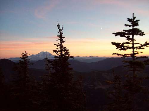
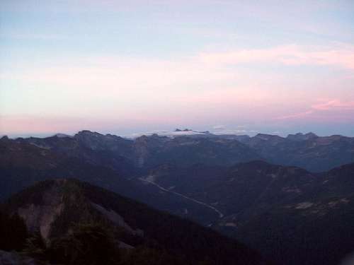
Humpback Mountain is one of the lesser known mountain in the I-90/Snoqualmie area. Though the trailhead to the route up is only 3 miles from the I-90 exit, it rarely receives traffic like Granite Mountain just accross the way. In some ways it is your standard I-90 peak, mostly a forest hike to the summit, barely a YDS Class 2 scramble to the summit and standard great views (boy is this area spoiled) of Mount Rainier, the Snoqualmie Region, down the I-90 valley, and distant Mount Stuart. The view of Rainier is especially gratifying. The difference here you will not run into nearly the crowd here that you will find on Mailbox, Granite, McCellan's Butte and others in the area.
The way up start as jeep road off of the dirt road mentioned in the getting there section. The stat line here is that this is a (3.4 mile; 2800 feet elevation gain trip). Take it roughly 3/4 of mile to a sand pit. The trail/bootpath starts off to the right of the sand pit. Keep your eye closely in this section. The first I was here I could not find the trail here. Follow the boot path (fairly easy to follow) up. It will rise steeply up the mountain. You will hit another dirt road roughly a 1/4 mile up. Continue going up the steep path. Though it is consistantly steep (like Mailbox for those who have climbed Mailbox) the advantage is that the dirt here actually acts like a cushion and is very easy on the knees compared to other. You come accross a number of ledges at about 2 miles and break out on the barely YDS Class 2 boulder scramble. This boulder scrambles go for a couple hundred yards past a false summit, which look neat and at first looks like the true summit, and finally hits the true summit. A fit person or avid hiker can do this peak in about hour to an hour and a half up and an hour down.

Getting There
VIA THE NW RIDGE ROUTE: From Exit 47 off of I-90 head south. Here is wher you want to reset your mileage and set it from the exit. At about 0.2 miles from Exit 4 you will hit a T in the road. Make a right near and head down the dirt road. Stay on the dirt road (good clearance for car) for about 1.3 miles (1.5 miles from Exit 47) until you see dirt road on your left. Make a left here and head up the road. At 1.5 miles from the previous intersection or 3.0 miles from Exit 47 you will hit a bend in the road and you with see jeep path that merges left. This is where you want to park your car.Red Tape
No trailhead fee due to the fact that this is more of a bootpath than a trail.Weather Conditions
 alt="Click for Snoqualmie Pass, Washington Forecast" height=60 width=468>
gimpilator - Apr 30, 2009 8:16 pm - Hasn't voted
Tinkham Road ClosedThe road today was closed at the first T. I thought may be it was seasonal but Magellan says it might stay closed for some time. Luckily I was on a motorcycle so I squeezed passed the signs and went as far as possible until a fallen tree stopped me.
PriceHardman - Jun 7, 2016 12:36 pm - Voted 8/10
Road OpenI've been up this peak in both 2014 and 2015 (late Spring on both occasions) and the road is open with no issues. Park by the second switchback.