
|
|
List |
|---|---|
|
|
Introduction
Contemporary Hungary is a rather flat country, most of its territory is alluvial plains. However, there are mountaineous areas as well, mainly along one line stretching across the whole country in WSW-ENE direction (consisting of several distinct mountain groups), plus a separate small massif in the SW (Mecsek Mts.). The building material of Hungarian mountains (or hills, if you prefer) varies: sedimental rocks (limestone and sandstone) can be found often as well as volcanic rocks (andesite, basalt), but there are some other types as well in small quantity.

Geological overview map of Hungary - darker colours indicate mountain areas
(linked from the Geological Institute of Hungary)
The List
 Tar-kő (950 m) Tar-kő (950 m) |
 Kékes-tető (1014 m) Kékes-tető (1014 m) |
 Istállós-kő (959 m) Istállós-kő (959 m) |
Concerning the spatial setup, it would be rather pointless to list country highpoints based on administrative regions. Instead I decided to pick some that are important and/or interesting. For that reason, the following compilation is not based on absolute ranks, as it does not include all of the highest mountains in the country. There are a couple of 900m+ and several 800m+ points which are not represented here. These ones are situated nearby one or another mountain in the list. On the other hand, a few mountains with lower elevations were chosen to be featured for different semi-arbitrary reasons (nice view, topographic isolation, etc.). A non-arbitrary list of absolute ranks can be found here.
Photos and other type of collaboration are more than welcome!
 Csóványos (938 m) Csóványos (938 m) |
 Pilis-tető (756 m) Pilis-tető (756 m) |
 Nagy-Milic (895 m) Nagy-Milic (895 m) |
| Name | Height | Range | Lat/Lon | Comment |
| Kékes-tető | 1014 m | Mátra | 47°52'22.26" N, 20°00'30.16" E | rank #1 360° panorama from TV-tower ski webcam |
| Galya-tető | 964 m | Mátra | 47°55'03.71" N, 19°55'16.81" E | rank #3 |
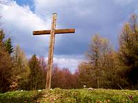
| Istállós-kő | 959 m | Bükk | 48°04'09.87" N, 20°25'47.30" E | rank #5 no view, but summit cross |
| Bálvány | 956 m | Bükk | 48°05'58.68" N, 20°28'20.16" E | rank #7 nice N view from GSM tower |
| Tar-kő | 950 m | Bükk | 48°03'25.76" N, 20°27'40.38" E | rank #11 natural viewpoint to the south |
| Csóványos | 938 m | Börzsöny | 47°56'58.87" N, 18°56'56.23" E | rank #19 nice panorama from geodetic tower |
| Nagy-Milic (SK: Veľký Milič) | 895 m | Zempléni/Szalánci-hegység (Zemplínské/Slanské vrchy) | 48°34'35.87" N, 21°27'29.09" E | rank #37 on the HU-SK border, free trespassing |
| Írott-kő (AT: Geschrieben Stein) | 880 m | Kőszegi-hegység (Günser Gebirge) | 47°21'09.99" N, 16°26'01.36" E | rank #44 highest point of the Transdanubian region on the HU-AT border, free trespassing |
| Pilis-tető | 756 m | Pilis | 47°41'19.93" N, 18°52'17.64" E | second highest point of the Transdanubian region (air-defence base in the 70's, now abandoned) |
| Kőris-hegy | 709 m | Bakony | 47°17'38.83" N, 17°45'12.80" E | third highest point of the Transdanubian region view from artificial tower |
| Dobogó-kő | 700 m | Visegrádi-hegység | 47°43'12.32" N, 18°53'56.50" E | popular natural viewpoint near Budapest (historic place of Hungarian hiking/mountaineering) |
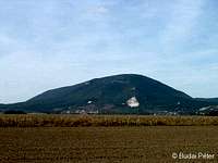
| Zengő | 682 m | Mecsek | 46°10'49.68" N, 18°22'38.71" E | highest point of Southern Hungary (close to Croatia) |
| Prédikálószék | 640 m | Visegrádi-hegység | 47°44'23.47" N, 18°55'12.06" E | fantastic view to the Danube bend nice trail by the Vadálló-kövek rocks |
 Highpoints of Börzsöny Mountains
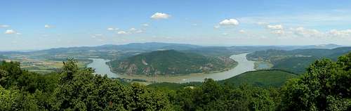 The Danube bend from Prédikálószék
 Winter view from Tar-kő
 View from Dobogó-kő
"Extraterrestrial"
The highest point of Hungarian speech area is actually missing from the above listing, as it lies far outside of present-day Hungary's borders. However, it is proper to be mentioned on this page. This mountain, called Madarasi-Hargita (RO: Harghita-Mădăraş) is located within present-day Romania (46°27'14.29" N, 25°34'56.27" E), on the land of the székely (ro: secui, de: szekler) ethnic group. Its height is 1801 m - still not very high, but way higher than any mountain inside Hungary. The top (which is a plateau rather than a peak) has a special atmosphere, with several rockpiles and countless messages arranged from smaller rock pieces by those who came to visit.

Madarasi-Hargita, the "sacred mountain"
(linked from this external source)