
|
|
Mountain/Rock |
|---|---|
|
|
41.02060°N / 114.8439°W |
|
|
Elko |
|
|
Hiking |
|
|
Spring, Summer, Fall |
|
|
8314 ft / 2534 m |
|
|
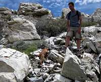
 SP Greg and his dog on the summit
 Wildflower display
Overview
This obscure mountain near Wells Nevada is also known as Little Cedar Mountain or as Wood HP. The name I like the best is found on the peakbagger.com list, Independence BM. With a prominence of 2141 feet, it comes in as the 141st most prominent peak in Nevada and despite the fact that it is a prominence peak, it is rarely visited. Prior to our arrival at the summit, there were only two peakbaggers who had signed the register since it was placed by one of them 8 years before and one other who most likely was a hunter. A benchmark and two witness benchmarks can be found on the summit as well as the remains of an old wood triangulation tower. I hope this page will be helpful to those who come after us.The views are exceptional with the Rubies to the west and Pilot peak to the east and if you are lucky, wild horses will entertain as they roam nearby. We counted over 20 wild horses during our visit. Be aware of ticks in the spring season, I picked 7 or 8 of them off of me so hence the warning about them.
Getting There
Drive south from Wells Nevada on US 93, passing the turnoff for highway 232 on the right after about 5 1/2 miles. Continue south for another mile and watch for a dirt road on the left (see map one) I like to use a GPS waypoint to help me be alert to the turnoff, making certain that drivers behind me will know of my intention to make a left turn (its a 70mph roadway). There is a mailbox at the gate with the number 230 on it and that will help you to know you hit the right dirt road. Open and close the gate behind you and drive about 9/10ths of a mile and when you encounter a "Y", take the left fork. Drive straight on what is the main road for about 2.8 miles (see map one) and watch for a faint track that takes off to the right. Waypointing this track will help you in finding it. I left a small 3 stone cairn at the junction but that may not be there when you visit.If you have a 2WD low clearance vehicle, find a spot to park it as the track (jeep road on the map) gets rough and may challenge those with high clearance and 4WD. This will add about 2.6 miles to the hike and 1100 feet of elevation gain but even with this, the distance to the summit will be around 4 miles and have less than 2000 feet of elevation gain.
If you continue on, you can stop at any time if you don't feel comfortable with a jeep road that sometimes resembles a goat path and even disappears into the high grass requiring you to discern where the road is. In my 2005 Tacoma, I was able to get to a saddle that is located at about the 7500' mark which is 2.6 miles from where we started so the road will get you to that saddle unless the road washes out sometime in the future. I parked at the saddle as the jeep track became more of an ATV track and my passengers and I were satisfied with how much further we had been able to get. I wouldn't attempt the road in a subaru (which I also own) and how far you want to push it is your choice. My passengers would've parked at the beginning since their 4wd vehicle is a bit wider than my truck and doesn't have the same amount of clearance.
 Map one Map one |  The road in The road in |  Map two Map two |
 Jeep road Jeep road |  Terrain Terrain |  Road? Road? |
Red Tape
None that I am aware of. The gate had no negative signage and we passed no residences or ranches on the way in. Private property and BLM property are often intermixed in areas like this so be aware that not all the land you might be on is public. Any questions might be directed to:Elko District Office,
Attn: Recreation Information,
3900 E. Idaho St., Elko, NV
89801-4611.
Camping
There is a good campground south of Wells called Angel Creek. I have camped there in the past and found the facilities adequate. You can find more information by clicking on this LINK.Not being totally sure of whether the land you are passing through on the way to the summit is public land or not, I would recommend the campground mentioned above. I saw no signs of fire rings or places where people had camped in the area.
Wild Horse area
Nevada has many areas where wild horses roam freely and this area had many that we were able to not only see but get fairly close too. Often however, where you find wild horses, you will also find a happy tick population so besure and make sure you don't carry some of those nasty little critters home with you.
 Wild Horse country
 Running herd
Weather & Wells
Wells WeatherWells Nevada has several places to eat including the usual fast food places (Quiznos, McD's, BurgerKing) Also gas stations and motels are available.
More information on Wells
Route and Summit stuff
I parked my truck at a saddle with an elevation of close to 7500'. I may have been able to drive to a higher saddle that had an elevation difference of close to 500 feet but the road, while possible, became even more of an ATV type track and I really like to get some hiking in on one of these efforts. My GPS showed that I was 1.3 miles from the summit and we had at least 800 feet of elevation to gain. I knew that by adding the bonus peak, Peak 8262, that we would end up with close to 1300 feet for the day so the 7500 foot saddle seemed like a good trailhead for us. Map two in the "getting there" section pretty much shows the way we went. A cross country traverse that led to our intended objective. Had I not been able to drive as far & as high as I did, our round trip would have added an additional 5 miles and over 1100 feet of elevation. Still, even that isn't problematic. Overall, it would have been 8 miles roundtrip and about 2000 feet of elevation gain, not a big deal without driving up the jeep track as I was able to. Benchmark Benchmark |  Register Register |  Rare visitors Rare visitors |
Summit views
 West West |  East East |  North North |
Man's best friend
 |  | 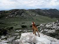 |
Bonus peaks (dumpster diving)
 Peak 8262
Summit register
Very few have found their way to the top of this one:A register was placed by Tom Roundtree in 2003 and since then it looks like this (as of 2014)
2006 - John Vitz (Calif)
2007 - a hunter
2011 - Greg Jagielski (UT)
2011 - Kadee Smith (UT)
2011 - Dean Molen (twice in two weeks)
2011 - Ken Jones (Wa)
2012 - Brad Boester (NV)
2012 - Mark Nichols (Az)
2012 - Richard Carey (Calif)
2012 - Dennis Poulin (Or)
2012 - Victor Zhou (UT)
2012 - Brett Hathaway (UT)
Note that many are from out of state with California, Arizona, Oregon, Nevada and Utah represented.