|
|
Mountain/Rock |
|---|---|
|
|
44.40090°N / 122.149°W |
|
|
5455 ft / 1663 m |
|
|
Overview
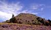
Iron Mountain, a cliffy, forested peak to the west of nearby Cone Peak, is one of the high points of the Western Cascades. The Western Cascades is a volcanic range that is significantly older than the High Cascades. The Western Cascades run parallel to, and just west of, Oregon's High Cascades. The Western Cascades peaks were once significantly higher than they presently are.
Iron Mountain is a popular ascent, and most people climb the peak via the Iron Mountain Trail, but the Cone Peak Trail also leads up to the summit. At the top, there is a lookout that is staffed in the summer.
Another attraction in the area is the great plant life. This area, from Iron Mountain east to North Peak, is filled with dozens of plants that are rare to the Western Cascades. There are also 17 types of trees in the area, more types than in any other area in the state.
The Tombstone Pass area is east of Sweet Home.
 |  |  |
Getting There
Cone Peak Trail: Drive on Highway 20 to a shoulder pull-out 0.7 mile east of the summit of Tombstone Pass. Park here.
Iron Mountain Trail: Drive on Highway 20. At a point 0.5 mile west of Tombstone Pass, turn south onto Road 15 (Deer Creek Road). Follow this road 0.3 mile to the Iron Mountain Trailhead.
Red Tape
A Northwest Forest Pass is required to park at or near the trailheads. DO NOT step off the trail onto the meadows. The meadows are very fragile!
When To Climb
Iron Mountain is usually climbed in the summer. To see the great wildflowers along the Cone Peak Trail, go in the early summer.
Camping
Camping is prohibited in the area. This is to protect the fragile plant life.
Mountain Conditions
Check with the Sweet Home Ranger District.
Brian Jenkins - Jul 13, 2003 6:37 pm - Voted 10/10
Untitled CommentPopoff,
Put in these coordinates and I think the Topozone Map will be corrected. Thanks.
44.4006 lat
-122.1478 long
Fun hike on this one today.
-Brian
Brian Jenkins - Sep 17, 2010 3:25 pm - Voted 10/10
Coordinates are still off7 years later................