
|
|
Mountain/Rock |
|---|---|
|
|
37.51018°N / 88.68237°W |
|
|
Johnson |
|
|
Hiking, Trad Climbing, Sport Climbing, Toprope, Bouldering |
|
|
Spring, Summer, Fall |
|
|
600 ft / 183 m |
|
|
Overview
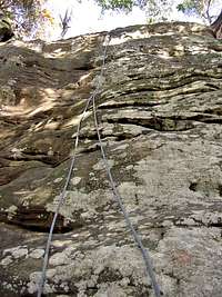
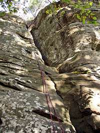
Located in the Shawnee National Forest, Jackson Falls offers arguably the best rock climbing in southern Illinois. There are roughly 60 climbing areas along the sandstone bluffs and freestanding boulders, each with multiple named routes on them. There are over 500 named routes in all. Most of the routes are 50-60 feet in height. The whole area sits in a very scenic glen.Most of the routes at Jackson Falls are sport routes, though there are a number of trad routes, and a few areas suitable for setting up a top-rope. Be warned that that there aren't many routes less than 5.10, and the easier routes (5.6 - 5.9) are in high demand on the busy weekends. There are also many excellent bouldering opportunities here.
Note that the sandstone rock offers exceptionally good friction. Don't let the ratings discourage you from climbing here. The sandstone makes the routes seem easier than the ratings.
There's a guidebook called Vertical Heartland that provides detailed descriptions of all the routes at Jackson Falls. The purpose of this page is not to recreate the level of detail that is in the guidebook, but rather to simply provide an overview of this popular climbing spot.


Getting There
Jackson Falls is located near the town of Ozark, IL, which is 40 miles east of Carbondale, IL and 40 miles north of the Kentucky border. Map it.Directions from Ozark, IL.
Look for the Ozark General Store at the intersection of Route 45 and Ozark Road. Turn east onto Ozark Road and follow it for 4.6 miles. Ozark Road makes a sharp left and becomes Trigg Tower Road at about 4.4 miles. Turn right onto Glen Street Falls Road. (The street sign is broken and currently reads "Street Road".) This small gravel road is located just before a white farm house. Follow the road past several farm houses and farm land for 2.2 miles where it drops down and crosses a small creek.
Turn right just before the creek and park at the trailhead sign. If that parking area is full, cross the creek and turn left. There are additional campsites and places to park there.
Glen Street Falls Road is graded and the area is accessible by low clearance vehicles. The only problem for cars could be if there is extremely heavy rain or flooding.
The climbing areas are only 1/2 mile to a mile from the trailhead. There is a map on the TH sign.

Red Tape
Jackson Falls is the only area within Shawnee National Forest where rock climbing is permitted. No fees or permits are required to climb or camp at Jackson Falls. However, there is a limit of 14 days for camping. It is open all year, but keep in mind that Glen Street Falls Road is not plowed in winter.Camping and other Amenities
There are primative campsites on both sides of Glen Street Falls Road near the trailhead. You can drive right up and park next to your campsite. If those campsites are full, there are additional campsites further down the road.Most campsites have fire rings. There are no picnic tables or campfire grills there. There are also no garbage cans. You must pack out all of your garbage. You also need to bring your own drinking water as there is no fresh water there. (Drinking from the creek is not advisable given its proximity to the campsites.)
There's a single outhouse at the trailhead that is well maintained and pretty clean.
Tick Warning
There are frequent tick warnings at Jackson Falls, as there are throughout Illinois. Protect yourself from Lyme Disease and take precautions against ticks, especially during peak summer months. The Illinois Department of Public Health issued this warning and list of recommendations in May 2007.Weather Forecast

Other Climbing Areas
The are a few other rock climbing areas within 30 minutes drive of Jackson Falls that are documented on RockClimbing.com: Cedar Bulff, Drapers Bluff, and Ferne Clyffe State Park.External Links
USFS Shawnee National Forest websiteRockClimbing.com - Fairly comprehensive route descriptions for Jackson Falls.