
|
|
Mountain/Rock |
|---|---|
|
|
33.91370°N / 111.784°W |
|
|
Maricopa |
|
|
Hiking |
|
|
Spring, Fall, Winter |
|
|
5013 ft / 1528 m |
|
|
Overview
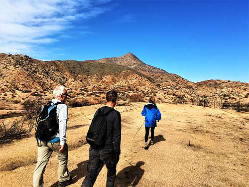
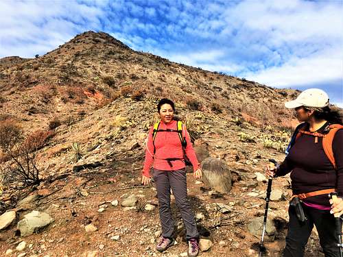
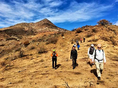
Kentuck Mountain is a prominent peak at the northeast edge of the Phoenix valleys. Located in the Seven Springs area northeast of Carefree, it is often seen and seldom hiked.
There are no well-marked routes to the summit and hiking to the summit requires between 800-1000’ of off-trail hiking (mostly open slope). The most straightforward route is from the east side. However, there are routes from the west side that have longer approaches that are less steep.
From trip logs, most people appear to have approached from the west side, not realizing that the east side is shorter and more straightforward.
Although its prominence is only 633’, Kentuck Mountain has unobstructed views for miles towards the Superstition Range, the Mazatzal Mountains, Browns Peak, and the mountains around Phoenix.
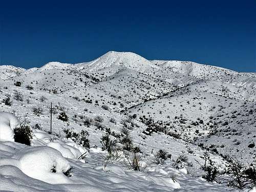
Kentuck Mountain is best hiked between November and March. Avoid hiking in the off-trail section above 70 degrees which is snake weather. Since the area is outside of the urban heat center and is quite a bit higher altitude than Phoenix, temperatures here are generally about 10 degrees cooler. In late February 2019, the area got about a foot of snow. This is quite rare. Try not to hike here after a rainstorm, since the terrain can get muddy.
Getting There
The east side route starts on the road to the Horseshoe Reservoir. Take Cave Creek Road to the junction with the road to Bartlett Dam, which is well marked. Once on the road to Bartlett Dam, drive about six miles until there are signs for Horseshoe Reservoir. Take that road north for almost two miles. On the left is a parking area with a gate and a sign. This is the starting point for Kentuck Mountain. There is room for 5-6 cars.
For the west side routes, from Phoenix go north from the 51 to the 101 heading east. From the 101, take the Pima exit in North Scottsdale and head north for almost 12 miles to a junction with Cave Creek Road. Take a right on Cave Creek Road and continue for nine miles where the road heads into the mountains and becomes Seven Springs Road (aka FR 24).
There are two starting points from this side. The first is the south parking area of Sears Kay Ruins. About a half mile after Cave Creek Road passes the last series of houses, the road veers to the left and then turns back north. Soon after the road turns back north, there’s a dirt road on the right that leads to a large parking area. The road is a quarter mile south of the main Sears Kay Ruins parking lot.
For the second route, continue past Sears Kay Ruins for another couple miles at which point the pavement ends. The road to Kentuck Mountain is about 2 ½ miles past this point. However, there is no parking at the junction. Instead park at a pull-out on the left side of the road about 250 yards to the south of the junction. Then walk up to the road and begin the hike.
Route Information
East Side Route
From the east side, there are a couple options, but the starting point is the same. Start up the road heading to the right. After about 1 1/3rd miles the road starts to head back south.
If just wanting to hike Kentuck Mountain, continue along the road as it heads to the south. After a third of a mile, take a hard right and stay on the main road. After another 250 yards there is a lesser road on the right. Take it and continue for another third of a mile. The road turns, but there is a trail that continues uphill. Take the trail for about a quarter mile. At this point, the trail takes a hard turn to the right. Instead, start hiking off-trail up to the ridge about 100’ above the trail. It is generally an open slope; although a recent fire in 2020 left it bare, and it will probably become thicker in the years ahead.
Once on the ridge, pick your route. The simplest way is to go straight up the southeast face. You reach the summit after gaining about 550’ in less than a third of a mile. It is steep, but doable.
The one-way distance to the summit via this route is a little over three miles gaining about 1,600’.
Once back at the trail, you can return the way you came, or take the trail to the right which leads up to Pt. 4366 or “Little Kentuck Mountain” in about three-quarters of a mile. The trail keeps going towards Peak 4,660’ if wanting a longer day; although the trail dissipates about 550’ below that summit.
West Side Routes
From Sears Kay Ruins
The most straight-forward route from the West Side is probably from the south parking lot of the Sears Kay Ruins.
From the parking lot, there is access to a Forest Road leading up the mountain. The problem is that local ranchers have put numerous No Trespassing signs along the road (as of September 2019). This is despite the fact that it is a Forest Road, with a welcome sign not far past the ranches. While there should be no legal restrictions on crossing the land via the Forest Road, it is understandable that people want to avoid conflict with the residents. However, if you are willing to endure potential conflict, this should be a legal access point.
The road enters the area with the adjacent ranches after about a half a mile. The road crosses between the ranches for 250 yards. Once at the side of the mountain, the road turns right and climbs up above the ranches and a Tonto National Forest sign is reached after a quarter mile, oddly welcoming travelers to the recreation area which the ranchers so desperately want to block access. This sign is about a mile from the parking area itself.
Continue for about 1 ¾ miles past the sign, and take a left on another road. This road leads into an old mining camp after about a half a mile. Once at the old mining camp, go off-trail through a canyon between two hillsides and you'll find the south ridge to the summit is ahead. The summit is 0.9 miles and 1,250’ above the old mining camp. It has some very steep sections, but it is doable. Descend the same way you came up.
This route about 9 ½ miles round trip with an elevation gain of 2,200’ on the ascent and adding another 400’+ on the descent back to the parking area.
Power line road
Walk 250 yards up the road and turn left on a road descending to Camp Creek as described in Scott Surgent’s trip report in the External Links section. This route has an advantage that a road leads up to the south side of the summit ridge, making route-finding quite easy. It has been the most popular route according to available summit logs.
Follow the road that winds to the south along power lines until turning back north and then east towards the ridge. The road climbs eventually up to about 4,230’, at which point you can continue the same direction, until you find a spot to head up steeply to the ridge that leads to the summit.
This route is about 10 miles round trip, with an elevation gain to the summit of over 1,600’. This is the preferred route if approaching from the west.
Red Tape
From the east side, cars are prohibited from blocking the gate, but there’s room to park to the side. From the west side, the only issue is dealing with the ranchers located east of the parking area south of Sears Kay Ruins.
External Links
Scott Surgent Trip Report (west side): http://www.surgent.net/highpoints/az/range/kentuck.html