
-
 6803 Hits
-
 73.06% Score
-
 3 Votes
|
|
Trailhead |
|---|---|
|
|
46.28740°N / 121.5522°W |
|
|
Summer |
|
|
4600 ft / 1402 m |
Overview
The name of this hike is a bit misleading. The trail follows a ridge line almost the entire distance. Having said that, the trail is relatively aggressive right out of the parking area.
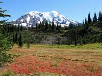
The trail climbs so steeply in places that steps have been put in place to decrease the erosion. One of the main reasons that this hike is so popular are the tremendous wildflower displays.
The trail climbs steeply for the first two miles, and is mostly in dense forest. Eventually, you break out into meadowed areas with vast wildflower displays. There are a number of small streams to cross as you continue toward Mt Adams.
As soon as you enter these more open areas you are treated to fantastic views of Mt Adams right in front of you and Mt Rainier in the distance to the north which is directly behind you.
At about 3 miles you come to the junction of Pacific Crest Trail #2000. To continue on to the High Divide Camp, bear right for a hundred feet or so and you will see the less used trail heading directly toward Mt Adams.
This part of the trail becomes much steeper and harder to follow, depending on the season you are there. It is about another mile of steep rocky climbing to the place called High Camp. This extra part of the hike is so worth the effort. You will find yourself on the very flank of Mt Adams, surrounded by more beauty than the eye can behold.
Getting there

Alternately, take Highway 14 east from Vancouver to Highway 141. Take Highway 141 north to Trout Lake. From Trout Lake, go north on Forest Service Road 23 about 26 miles to the junction with Road 2329. The last 9 miles is gravel.
Go east on Road 2329, which is gravel most of the way, past Takhalakh Lake Campground, 6 miles to the trailhead.
2 miles before you reach Killen Creek Trailhead is High Camp Trailhead. It connects up to the Pacific Crest Trail 1.2 miles south of where the Killen Creek Trail connects to the PCT. If you were going south on the PCT this would be better. It's easy to accidentally start here rather than the Killen Creek Trailhead because they're so similar.
From Troutlake: Buck Creek Rd/Natl Forest Develop Road 23 Rd/Randle Rd Continue to follow Natl Forest Develop Road 23, Continue onto Nat for Dev Rd 2329(from here see above)
Red Tape
Not much red tape.Northwest Forest Pass can be obtained and filled out at trail head and attached to backpack(or carry) place other copy in slot.
Volcano pass is required if hiking/climbing above 7000'.
Nearby camping
There are a couple near-by campgrounds.Takhalakh Lake Campground has about 40 sites, drinking water,Rv's and tends to be full on weekends.
Killen Creek Campground is a mile past the trailhead on Road 2329. It is free, no drinking water, picnic tables, pit toilet, and isn't very busy.