
|
|
Mountain/Rock |
|---|---|
|
|
46.79000°N / 84.319°W |
|
|
Algoma District |
|
|
Hiking |
|
|
Spring, Summer, Fall, Winter |
|
|
1840 ft / 561 m |
|
|
One Without the Other...
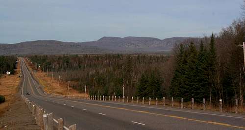 Goulais River Valley
About 15 minutes north of Sault Sainte Marie, Ontario the Great Northern Highway makes a rather steep descent to the Goulais River Valley opening up a stunning panorama of Lake Superior and the highlands to the north. To the northeast from this vantage point one can’t help but notice an impressive cliff face rising directly from the opposite side of the valley. Above these cliffs stands a single peak which rises higher than any of its neighbors. The cliffs are those unofficially known as the Robertson Lake Cliffs, named for a neighboring body of water, while the peak rising above is that of King Mountain.
Of the two Robertson Lake Cliffs is by far the most scenic offering beautiful views to the south of the hills immediately north of the Soo. King Mountain, on its own, is only marginally worthwhile. Luckily, if one was looking for a nice, long afternoon hike, an extensinve trail system in the area provides the opportunity to visit both of these sites together. In short, I’d only recommend visiting King Mountain if you’re planning to hike over to the cliffs as well, otherwise I’d just take the shorter southern route to the cliffs and skip King Mountain, on its own, for one of the more beautiful small peaks to the north such as Griffin Lake Peak or Batchawana Mountian.
King Mountain...

Ever looked forward to a promising hike only to be disappointed by what you found once you got there? The trip up King Mountain can be just that so I’m here to warn you. To be sure, King Mountain, accessed from the Stokely Lodge Ski Lodge is one of the most easily accessible peaks in the Algoma District. Armed with a good map of the local trail system the peak is quite easy to find although the trails can be quite overgrown in the summer (especially the last half mile or so in which the hike takes on all the characteristics of a bushwhack). Unfortunately, the small cliffs visible from below that surround the summit are not located high enough on the peak to offer views from the summit. Thick brush surrounds the summit proper, which offers no views. You have to do a small amount of extra bushwhacking off the south side of the peak to get any views whatsoever. Fortunately, as I mentioned above, one could continue north on seldom used trails and eventually make their way out to Robertson Lake Cliffs. On its own, you should only bother climbing King Mountain if you’re one of the very few interested in climbing Ontario’s remote north peaks. I include it here only because it neighbors’ Robertson Lake Cliffs which include much more interesting terrain…
 Summit View
 Overgrown Trail
 Trail Map
Robertson Lake Cliffs...
 The Cliffs
Unofficially named for nearby Robertson Lake, these 600’ high cliffs rise dramatically from the northern side of the Goulais River valley. The cliffs offer, in my opinion, the most striking views for the least effort in all of the Algoma District. Couple that with the fact that they are within a half hour of a couple hundred thousand people and you’d expect them to be quite overrun. Pleasantly, this isn’t the case. Odds are if you mention the name to a local they’ll have no idea what you’re talking about.
The lack of popularity is likely due to the fact that the cliffs have only recently come into public hands. Until recently this heavily forested area was the scene of extensive logging. Seeking to protect this valuable area from further destruction a local conservation group, the Algoma Highlands Conservancy, recently purchased the property encompassing the cliffs in their entirety. Once protected, the cliffs offered an obvious and beautiful route for the Voyageur Trail, a long distance trail that, once completed, will stretch along the entire north shore of Lake Superior. Therefore, in contrast to the trails up nearby King Mountain, the trail along Robertson Lake Cliffs is well-marked and maintained. Although there are no official guides to the area I estimate the trail up to the highest of the cliffs to be around a mile, though the distance can be longer if you decide to continue to the lower cliffs to the west.
 Clifftop
 Rockfield
Getting There...
 Stokely Lodge
King Mountain Trailhead (Stokely Creek Lodge):
Stokely Creek Lodge is located about 30 km. (18 mi.) north of Sault Sainte Marie, Ontario. Follow the Trans Canada (ON-17 N) north to the Goulais River Bridge. About 2-miles north of the river watch for a large white barn and signs pointing you in the direction of the lodge. At this point simply follow the signage and you should have no trouble finding Stokely Creek. Please remember this is a privately owned business which is kind enough to allow visitors to use their trails free of charge in the summer. Please respect those that have paid to stay there and park out at the entrance and walk the short distance into the lodge and the trailheads.
 Robertson Lake Road
Robertson Lake Cliffs:
The trailhead for the cliffs is found by following the same directions for King Mountian up to the point you turn off the Trans Canada (ON-17 N). Once turning off the main highway watch for Robertson Lake Road a short distance ahead on your right and turn onto it. Within a mile or so you will loose the pavement. Within another mile the cliffs themselves begin to rise above the trees in front of you. At this point watch for the road to climb a rather steep slope. Near the top of the climb keep an eye out for a small pull-off on the right with the trailhead directly across on the left. This is the trailhead.
Both trailheads are accessible in the winter.
For More Info...
Stokely Creek Lodge - Cross country ski lodge which owns King Mountain. Site has good info and necessary maps for skiing/hiking in the area.Algoma Highlands Conservancy - The organization resposible for the rescue and preservation of the Robertson Lake Cliffs area.
The Atlas of Canada (Toporama) - This is always a good source for maps if you're going to be wandering the backwoods of Algoma.
Ontario High Points - A great wealth of information for anyone planning to explore the peaks of Ontario. Derek, the webmaster, is often my main source for beta on the region.
