
-
 3109 Hits
-
 74.01% Score
-
 4 Votes
|
|
Mountain/Rock |
|---|---|
|
|
40.47797°N / 115.47061°W |
|
|
Elko |
|
|
Hiking, Mountaineering, Mixed, Scrambling |
|
|
Spring, Summer, Fall |
|
|
11031 ft / 3362 m |
|
|
Overview
The mighty 11031ft/3362m King Peak in Nevada's expansive Ruby Mountains is named after the 19th-century American geologist Clarence King, as is Utah's high point--King's Peak--among some other peaks of the western United States.

Though King Peak is indeed a higher-elevation peak in this range, it is not the highest point of Nevada, nor is it the highest peak of the Ruby Mountains. But it is nonetheless special, for it is one of the range's nine official peaks greater than 11,000 feet, 3350 meters---a few other peaks in the range are also slightly above 11,000ft, though they are not labeled on official maps. This peak is also the southernmost peak of the range that surpasses this elevation milestone. Perhaps most important is that it is one of the more hazardous peaks of the range due to the steep and sudden drop-offs on each side of its narrow-though-short summit ridge. Unlike other peaks here that have plenty of room for error near the summit, King Peak does not.
Getting There
Since certainly a myriad of ways exist in terms of parking one's vehicle to begin a hike to King Peak, we'll only list three major means of doing so.
Overland Lake trailhead via Ruby Valley Road (NV-767)
Starting elevation of approximately 6700 feet, 2042 meters, 4 miles from trailhead to peak in straight line
***High-clearance vehicle is necessary.*** The Overland Lake trailhead offers the shortest hike in order to begin heading up to King Peak. It of course also provides a chance to visit Overland Lake itself, which is directly off of the Ruby Crest Trail.
Note that public utilities such as electricty or restrooms are NOT at this trailhead.
If coming anwhere from the east of the Ruby Mountains, you can't go wrong by taking State Highway 93.
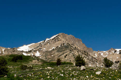
The Ruby Mountain Wilderness sign as seen on the trail from the Overland Lake TH that then runs into the Ruby Crest Trail:
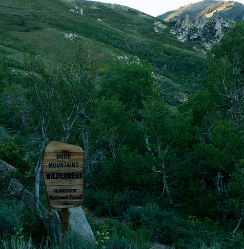
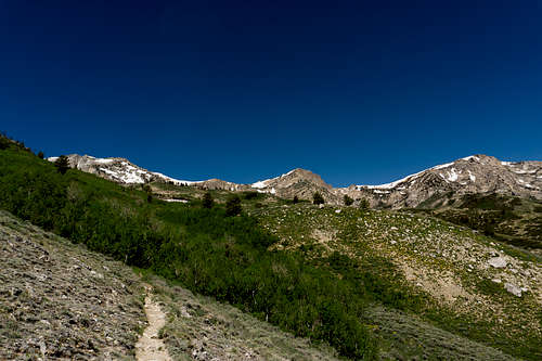
The trail between the wilderness boundary and the Ruby Crest Trail. King Peak is visible just to right of center in below photograph:
If coming from Las Vegas area
From Las Vegas the most direct way is via I-15 to 93. 93 quickly becomes countryside, and stay on it until you see signs for 318/375. A general store will be on the right where the turn is. Turn left there and then soon take a right on 318 to continue north. The last towns you'll pass through will be Lund and then Preston before the road ends at 6. Take a right onto 6 and ride that out until you reach Ely, NV. This is a good place to get out and stretch. The town has plenty of amenities such as remodeled hotels, convenient marts, truck stops, etc. Top off the fuel tank here if need be, and then...
Option 1 - When you're not concerned about driving on 80 miles of long, well-maintained dirt road
Get on US-50 west, which soon is heading northwest out of Ely. Stay on 50 for approximately 30 miles until you see County Road 3 on the right. Some signs will be there, and also sometimes vehicles are there for some of the Bald Mountain mine workers. Stay on this road for roughly 80 miles, during which you'll pass the mine, and then later Ruby Lake and the Ruby marshes, part of the Ruby Lake National Wildlife Refuge, all on the right. Also make sure to pass the Harrison Pass turn that's to the left. Don't take that, and keep straight heading north. After approximately 8.5 miles the road will fork and you'll stay left on Ruby Valley Road (the right road is Old Ruby Valley Road). After a little less than half a mile, you'll be stopping to open the fence on your left, which is the final half-to-three-quarter-mile stretch up to the trailhead.
Option 2 - When you want to drive on as much paved road as possible
Head north out of Ely on 93 for approximately 58 miles. Then 93 forks into 93 and 93 Alternate. Take a left here, which puts you heading toward Wells, NV. After roughly 49 miles you'll then take a left on 229. After 12 miles or so the road will become Ruby Valley Road, and you'll continue straight on it for approximately 15 miles, heading south with the magestic Rubies on your right. This road will soon become dirt, but it's decently maintained for the many ranchers in the area. You'll reach a small fork in the road, and stay right. Then no more than half a mile more is where the right turn is, which is the final stretch to the trailhead on the right. Stop and remove the easy section of fencing in order to drive up this final section. Close it behind you and head up to the trailhead.
If coming from southern Utah
Those coming from southern Utah can head to Delta, UT in order to hop on US-50 west for approximately 150 miles until reaching Ely, NV. From there, see Options 1/2 above.
If coming from Interstate 80
The most straight-forward approach to the Overland Lake trailhead from Interstate 80 involves simply getting to Wells, NV, just off of the highway, and then traveling south on 93 for approximately 27 miles. Then take a right on 229. After 12 miles or so the road will become Ruby Valley Road, and you'll continue straight on it for approximately 15 miles, heading south with the magestic Rubies on your right. This road will soon become dirt, but it's decently maintained for the many ranchers in the area. You'll reach a small fork in the road, and stay right. Then no more than half a mile more is where the right turn is, which is the final stretch to the trailhead on the right. Stop and remove the easy section of fencing in order to drive up this final section. Close it behind you and head up to the trailhead.
If coming from US-50 west
For anyone to the southwest of the range, it may be desirable to avoid Interstate 80 or Las Vegas. This simply means that you'll head over on US-50 and head east on it. Pass through Eureka, NV, and continue eastbound for approximately 45 miles. Then County Road 3 will appear on your left. Option 1 above in the Las Vegas section outlines that route. Otherwise take Option 2.
Another route does exist that prevents one from having to to go all the way to Ely, though it involves a lot of dirt-road travel as well. In snowier, rainier times of year this can become a slushy and/or muddy stretch to drive on as well. Pass through Eureka and continue eastbound on 50 for approximately 15 miles. Begin to slow down as you see a grove of trees on the right. Strawberry Road will be on the left, across from the trees. Take a left there. Then continue on this paved road, which is also known as 892, for approximately 15 miles. You'll approach on your right an RV park for the mining employees--basically just a bunch of RVs parked in a field--and then you'll pass that and up ahead no more than a mile is a sign for Warm Springs. Here you'll want to take a right. From there you'll continue on this dirt road for 35 miles, and though the road will fork at times, you simply stay on the main dirt road. Something to assure you that you are on the right road will be the small mile marker signs. When you turn off of 892, the sign will begin with 1, and it will end at 35, where you'll finally be reunited with pavement. Take a right at this point, and you'll head straight in to Harrison Pass from there. After approximately 10 miles you'll be on the east side of the Rubies, and then take a left on Ruby Valley Road/767. Stay on this road for approximately 8.5 miles, and finally the road will fork and you'll stay left on Ruby Valley Road (the right road is Old Ruby Valley Road). After a little less than half a mile, you'll be stopping to open the fence on your left, which is the final half-to-three-quarter-mile stretch up to the trailhead.
Roads Ends trailhead via the Lamoille Canyon Scenic Byway
Starting elevation of approximately 8600 feet, 2620 meters, 10 miles from trailhead to peak in straight line
Note that a men's and women's single-toilet restroom is available at this trailhead.
Any vehicle can get to this trailhead since the entire way to it is paved. In terms of hiking, this is a longer route that provides more experience on the Ruby Crest Trail along with more time around some higher peaks of this range, including Wines Peak, which one must traverse on the RCT from Roads End TH in order to get to King Peak. Also, an easy hike up from Liberty Pass is Liberty Peak, so the opportunity is obviously there to visit multiple peaks during the voyage along the RTC to King Peak.
If coming from Interstate 80
To arrive at the trailhead via Interstate 80 to Elko, NV, people most often take either the East Elko exit or the Downtown Elko exit. If taking the East Elko exit, one simply needs to turn toward downtown and head toward 12th Street. Signs for Ruby Mountain Recreational Area will be around too that will help guide the way. Stay on Lamoille Highway for approximately 18 miles, which will entail going up and over Lamoille Pass and then going by two shopping center areas and a traffic circle, which arrives after 10.5 miles or so. Get in the left lane once you are approaching it, enter the circle carefully, and take the second right as you round the turn. Continue on until you see a 35mph sign and also signs for the town of Lamoille and the Lamoille Canyon Scenic Byway. Turn right just after the 35 mph sign. This quickly becomes national forest territory and one of the most impressive scenic byways in Nevada despite its brief 12 miles of length. The end of the road is, appropriately, the Roads End trailhead.
If coming from US-50
Note that in snowier, rainier times of year this can become a slushy and/or muddy stretch to drive on. If coming from Eureka (from the west) on US50, continue eastbound on 50 for approximately 15 miles. Begin to slow down as you see a grove of trees on the right. Strawberry Road will be on the left, across from the trees. Take a left there. If coming from Ely, stay on US50 for approximately 61 miles until you enter a wide-open valley and a straight stretch of road that goes on for miles. The grove of trees will be on your left in this case. Turn right, north, across the street from these trees. Then continue on this paved road, which is also known as 892, for approximately 15 miles. You'll approach on your right an RV park for the mining employees--basically just a bunch of RVs parked in a field--and then you'll pass that and up ahead no more than a mile is a sign for Warm Springs. Here you'll want to take a right. From there you'll continue on this dirt road for 35 miles, and though the road will fork at times, you simply stay on the main dirt road. Something to assure you that you are on the right road will be the small mile marker signs. When you turn off of 892, the sign will begin with 1, and it will end at 35, where you'll finally be reunited with pavement. Take a left at that point, and you'll be on SR228, i.e., the final, 30-mile stretch of road that connects you with Lamoille Highway. Jiggs Highway will end perpendicular to Lamoille Highway in Spring Creek, NV. Take a right and head toward the Ruby Mountains, though you may want to stop at the shopping center and convenience mart across the street at this intersection. From here it's 12 miles to the right turn you'll need to take. Navigate the traffic circle and continue heading straight toward the Rubies. The 35 mph sign is the cue to slow down and prepare for a sharp right turn onto the national forest road, which quickly becomes the Lamoille Canyon Scenic Byway. 12 more miles and the road ends at the trailhead.
Green Mountain trailhead via Harrison Pass Road (NFR 357/113)
Starting elevation of approximately 8200 feet, 2500 meters, 8 miles from trailhead to peak in straight line
***High-clearance vehicle is necessary.*** This is certainly the southernmost point that one would want to start from in order to visit King Peak.
Note that public utilities such as electricty or restrooms are NOT at this trailhead.
If coming from Interstate 80
Arguably the best route from Interstate 80 to the Green Mountain trailhead depends on which side of the Rubies you are coming from. If you're coming from the east, then take a break in Wells, NV, and head down 93 for roughly 28 miles. Then take a right on 229, which becomes Ruby Valley Road/767 in 13 or so. Then follow the road south for approximately 25 miles until you see the signs for Harrison Pass Road. Turn right, west, toward the mountains, and in about 3.5 miles the road up to the trailhead will be on the right.
When approaching the range from the west, go through Elko and head to Spring Creek. The first stop light after going up and over Lamoille Pass is where the right turn is. (A convenience store/fuel station, a grocery store, and other stores are on the left side of this intersection.) Take a right on Jiggs Highway at the first stop light after going over Lamoille Pass into Spring Creek. Stay on Jiggs Highway/228, which will become Harrison Pass Road (simply follow the signs), all for about 40 miles until your turn up to the trailhead is on your left.
If coming from US 50
Approximately 15 miles east of Eureka, NV on US-50 you'll see Strawberry Road on the north side of the road. Turn there and then for the next 50 miles follow the signs to Harrison Pass. Go approximately 11 miles until the Green Mountain trailhead sign appears on the north side of the road. Head up the road for approximately 4.5 miles until reaching the trailhead.
Routes
Two main accepted routes exist for summitting King Peak. This may seem obvious if taking a look at the contours in the below map snippet via the Avenza App (Map is "Ruby Mountains Wilderness Humboldt-Toiyabe National Forest 2021"). The vertical distance between contour lines is 200ft. Note the 1000-foot differences immediately surrounding the upper half of the peak.
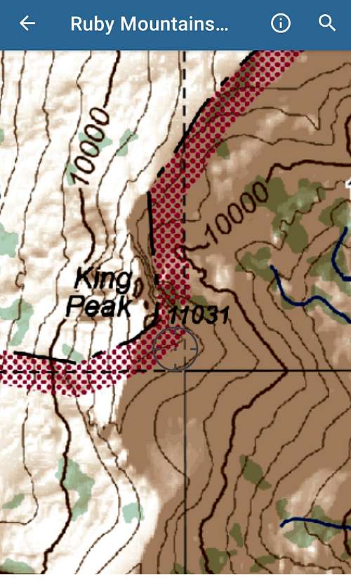
Therefore the most reasonable ways of reaching this peak are from the south. From this direction are two most popular ways.
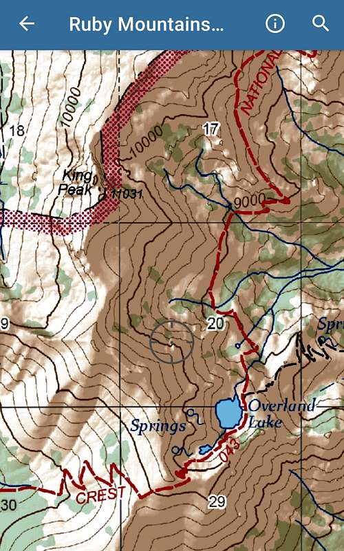
Northern ridgeline above Overland Lake
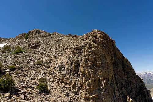
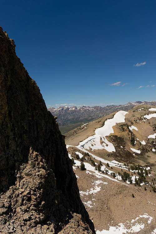
The point at which the Ruby Crest Trail is highest above Overland Lake provides a relatively easy opportunity to get to King Peak, for a long ridgeline exists between here and the peak, which is visible in the map sample above. Heading north from the Ruby Crest Trail (in Red) at roughly the 10100' mark allows for a manageable ridge walk and some side-hilling to the summit. Here is a view near the summit of the ridgeline coming from the south.
Southeastern mountainside
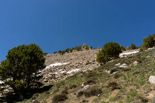
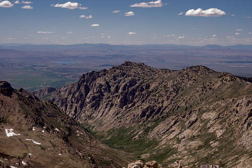
The second way is arbuably much more laborious, for it involves traversing a nearly constant slope of 45 to 55 degrees degrees that eventually meets rock fields that can be tedious and time consuming to traverse. The below photograph displays a navigable way up from the closest section of Ruby Crest Trail.
Higher up near the final boulder fields on southeast side of King Peak:
Relief comes high up finally, at which point one gets a real feel for the exposure of this high Ruby Mountain peak.
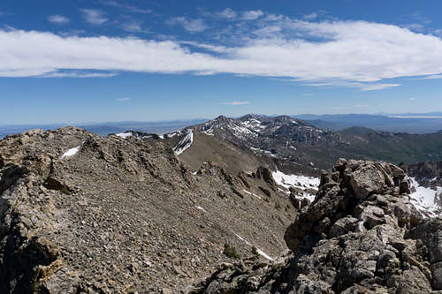
The exposed summit ridge as seen from the south:
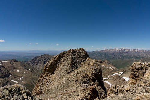
Looking toward the west from King Peak. South Fork Reservoir is visible just left of center.
Red Tape
The main rules to abide by concern fires and not starting any camp fires during the driest months of, typically, July and August. You can stay up to date by visiting this site: Mountain City-Ruby Mountains-Jarbidge Ranger District
This is largely a wilderness area, and so Leave No Trace rules are in place as usual.
When to Climb
The time to climb is the typical Spring-Summer-Fall period. Getting anywhere successfully in the snow deep in the wilderness during the winter is unlikely to be of any enjoyment, and is more than likely to prove next to impossible anyway. It's a shame to admit that one may need to keep an eye on wildfire activity west of the area in order to be sure that one will have good views at the summit.
Camping
Arguably the most attractive camp site for a next-day King Peak attempt is Overland Lake. Not only are there many level areas to place campsites, but one of the range's largest alpine lakes is literally a stone's throw away. Elsewhere, especially during the peak of summer, water supply can be scarce.
But certainly campsites can be put up anywhere in the wilderness that is comfortable.
External Links
Area updates and alerts can be found here: Mountain City-Ruby Mountains-Jarbidge Ranger District
Weather info: King Peak mountain forecast
Info on Clarence King, to whom this peak is attributed.