


winemanvan - Sep 26, 2011 1:18 pm - Voted 10/10
Excellent ImagePerfect view of one of the most beautiful and rugged places in the Sierra. Thanks!
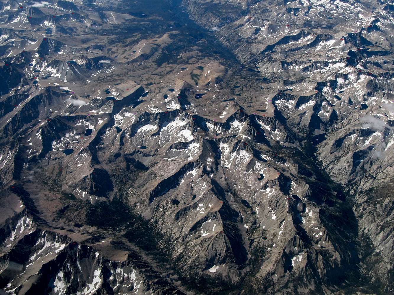
cgundersen - Oct 3, 2011 1:34 pm - Hasn't voted
Labels?dave,
I left a comment on HST to the effect that I thought that Harrison Pass and Junction Pass were not quite at the spots indicated on the photo. This, I think, is testimony to the amazing quality of the photo that one can see details that raise such doubts. Anyway, see what you think!

David Senesac - Oct 4, 2011 1:44 am - Hasn't voted
Re: Labels?I quite enjoy analyzing maps so this is a fun exercise thankyou.
Well my Junction Pass code is JPa. My Mount Williamson USGS 7.5m topo shows it due south of the east edge of lake 3685 that given its shape is indeed the body of water immediately below. Also note lake 3592 further down the map shows northwest of Mt Kieth. The southwest ridge from Mt Kieth continues to the pass then further west a deeper saddle and Junction Peak. A line can be drawn from lake 3685 and the lake about 1 mile northwest of Shepherd Pass at 3680+ that bisects the pass on the topo. One can indeed see that lake too in the image and a line between those two image elements bisects the pass.
Looking at the pass area against the topo more closely, notice how the image snowfield on the northside of lake 3685 is a bit larger than the one on the topo and fills the entire area of the indicated small circular moraine. The jetliner flew over about 10am or so that sun illuminates the ramp coming down from the pass as would be expected.
Harrison Pass is on my Mt. Brewer 7.5m USGS topo with my code HP. And yes I immediately see it is in the wrong location and not where I had intended. Good find, cgundersen. I do recall looking at that particular pass more closely trying to note the exact spot of the brink. All the first text codes I put on the image were red that I later decided to use just for the peaks with magenta other elements. Thus after removing the red text for that pass, I apparently put the HP back in a different position maybe because that is where the H in Harrison shows on the map.
On the topo is a marshy area due south about 3/4 mile. That shows on the image as a slightly darker area above and left of a snowfield. I just added text for Deerhorn Saddle, DS. To image left of DS up a slope is the topo ridge point at 4080+. If on the topo one draws a line between point 4080+ and the center of the mentioned marshy area, it will bisect the exact spot the topo Harrison Pass trail shows dropping over the lip. Doing the same on the image does the same, right where the lower left leg of the H in HP is now placed. One can see a triangular snow patch just to its left.
David
cgundersen - Oct 4, 2011 11:16 am - Hasn't voted
Now, it's the map labels!Hi David,
http://sierrabackpacker.com/JunctionPeak.htm
and http://www.klofas.com/topo/7.5/m.html
Hi David,
Checking both the 7.5 minute Mt. Williamson topo and the sierrabackpacker location for Junction Pass (the appended links), they both show it to the East of where the use trail is indicated (but, not in exactly the same spot). In my experience on Junction Pass, I've gone where the use trail is shown. My recollection is that you'd likely need ropes where both these resources show the pass. From this, I'd conclude either that Junction Pass is a much tougher entity and that the thing I've been over is not Junction Pass, or that the maps are mis-labeled. I'm leaning toward the later. But, if one is looking for more excitement, then try following the labels.
Cameron

andymorgosh - Feb 18, 2013 5:54 pm - Voted 10/10
Thanks!This is one of my top three photos...ever! Thanks very much for sharing. Are there other aerials of the Sierras as good as this one?

T. White - Aug 26, 2018 10:58 pm - Voted 10/10
Outstanding photoRare that weather and window clarity come together to make a shot like this. Thanks for sharing and taking the time to annotate it!


Comments
Post a Comment