
-
 5881 Hits
-
 86.85% Score
-
 23 Votes
|
|
Mountain/Rock |
|---|---|
|
|
37.20150°N / 105.43087°W |
|
|
Costilla |
|
|
Hiking |
|
|
Spring, Summer, Fall, Winter |
|
|
8295 ft / 2528 m |
|
|
Overview
 La Capilla de Todos Los Santos and the Sangres
From the north, la Mesa de la Piedad y de la Misericordia (the flat-topped Hill of Piety and Mercy) looks like any other of the numerous crumbling, black-rock volcanic mesas speckled throughout the region. Dotted with sage brush and grasses, it guards the northwestern end of the town of San Luis, the oldest continually inhabited (by westerners, anyhow) town in Colorado. From the south, however, a different scene emerges. Large letters consisting of white-washed boulders announce that you have arrived in “San Luis | Oldest Town In Colo.”
A visit to la Mesa de la Piedad y de la Misericordia is like no other hill, butte, mesa, peak or mountain many of us will visit. This is because this mesa top is home to a Catholic chapel, La Capilla de Todos Los Santos (The Chapel of All Saints) and the southern slopes and up to the mesa top is home to a shrine to the Stations of the Cross designed by world-renowned, locally-grown sculptor Huberto Maestas. (The mesa is also, according to warning signs posted in the area, home to numerous rattlesnakes!) Furthermore, the mesa hosts a memorial to the Memorial to the Mexican Martyrs, a monument to several Catholics executed by the Mexican government during the early 20th century and later canonized by the Catholic Church.
In addition to offering a religious, architectural, cultural and historical experience, la Mesa de la Piedad y de la Misericordia provides fantastic views of the sprawling San Luis Valley and the mighty Sangre de Criso range rising to the east. In fair weather, the eastern San Juan mountains will be visible to the west as well as the mountains of New Mexico to the south.
Getting There

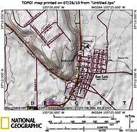
The Mesa rises above the town of San Luis to the northwest, at the intersection of CO Hwy 159 and CO Hwy 142. Park in town (curbside or in the designated Shrine parking) and head briefly west on CO Hwy 142 along a sidewalk. Cross under a wooden archway to begin the walking ascent of the mesa through the Stations of the Cross sculptures. The actual mesa summit sits west of the Memorial to the Mexican Martyrs. While no formal trail exists to the top, apparently plenty of locals and visitors alike make the trek up the final rocky crest to the top to take in view of the entire grounds. There is a faint social trail through the rocks to the summit, just be mindful of rattlesnakes!
Red Tape & Cultural Considerations
 Several statues for the Mexican Martyrs
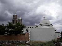 Clouds build over the chapel
 Final rocky steps to the top
 The summit cone
Be mindful of the fact that this a visit to this mesa is, for many, a religious experience, the geographic end point of a holy pilgrimage. Where some visitors see a volcanic mesa and some artwork plus historic architecture, others see a highly spiritual experience of suffering, death and resurrection. Even if your religious convictions do not align with the Christian beliefs of the pilgrims and the parish, please retain your composure and show respect. Keep your voice down and dress respectfully (no tight, revealing or low-cut tops, no short-shorts, no tank-tops, etc.) Finally, your visit takes you onto parish grounds, so respect any posted warnings or rules.
During Holy Week and on Easter Sunday (always the first Sunday on or after the first full moon following the vernal equinox, which can range anywhere from 22nd March to 25th April) there are numerous religious events, celebrations and observances.
Camping & Lodging
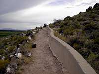 Beginning the gradual ascent
 Gateway at bottom of walkway
The San Luis Valley and Costilla County both have limited public land, by Colorado Standards. Public lands camping in the southern end of the Colorado part of the valley are extremely limited. Below are some basic camping lodging guidelines.
Hotels and Motels: The small town of San Luis and Fort Garland (17 miles to the north) each have one or two small, simple, family-run hotels. A wider variety of lodging can be found in Alamosa (roughly 40 miles northwest of San Luis).
There is also camping available in Great Sand Dunes National Park & Preserve, about 1 hour north of San Luis. If National Park camping is full, try The Oasis, a family-run campground just south of park boundaries on CO Hwy 150.
Weather & Seasons
 Mesa summit behind martyrs memorial
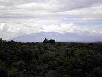 Clouds over the Sangre de Cristo Mountains
 La Capilla de Todos Los Santos
 Detail of the chapel
Summers in the southern San Luis Valley can be quite hot, despite the high elevation, but bearable due to low humidity. Late summer (from mid-July through August) is the “monsoon season” here, meaning afternoon thunderstorms and occasionally heavy rain throughout the day. Though the center of the San Luis Valley is a true desert (based on low precipitation), when it rains here, it pours! Nights are cool and crisp even in the peak of summer.
Winters in San Luis see little snow, compared to the mountains surrounding this valley. While the days may be sunny and warm, cold overnight temperatures (single digits Fahrenheit) are not unusual.
External Links
 The chapel from the mesa top
Learn more about the mesa and chapel in this Pueblo Chieftan article.
Learne more about the town of San Luis and Costilla County.