
-
 2799 Hits
-
 73.8% Score
-
 4 Votes
|
|
Mountain/Rock |
|---|---|
|
|
40.67724°N / 115.44008°W |
|
|
Elko |
|
|
Hiking |
|
|
Spring, Summer, Fall, Winter |
|
|
9875 ft / 3010 m |
|
|
Overview
Lamoille Peak is an unofficially named peak that sits at approximately 9875 ft (3010 meters) on the north side of Nevada's Lamoille Canyon Scenic Byway entrance. It is basically the first visible peak on the left side of the road as you are looking at the mouth of the canyon from the adjacent town of Spring Creek (just to the west of this section of the range). Though it is not a particularly popular peak of the Ruby Mountains, it is nonetheless a magnificent one to visit, for it offers a vantage point from where visitors can see the north-facing wall of Lamoille Canyon while simultaneously seeing Ruby Dome, Mount Gilbert, Snow Lake Peak, Thomas Peak, Verdi Peak, South Fork Reservoir, the East-Humboldt Range and beyond, all in one sweeping panorama. Accessible nearly year-round, not only is this an outstanding peak for conditioning, it is more simply perfect for getting out of the house to hike up a mountainside without having to plan more extensively. Given that this is hardly a sought-after peak, solitude is nearly promised any time of year.
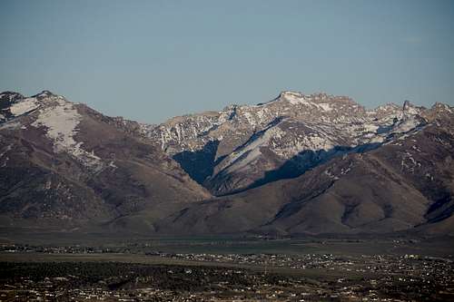
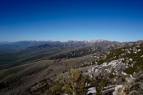
In the image below, Lamoille Peak nearly blends in to the slightly higher, farther-away peak on the left side of the mouth of Lamoille Canyon. This picture was taken just north of Lamoille Pass near the "Elko E."
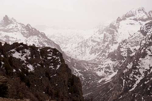
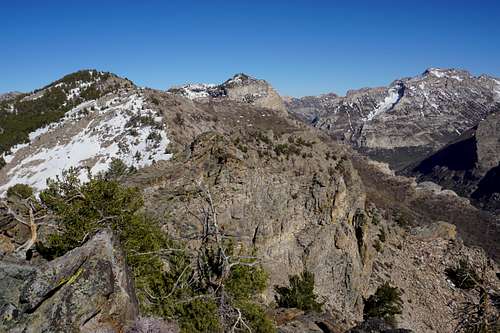
One of the most special traits of this peak is that it allows for a nearly direct view into Lamoille Canyon's right fork, which is a massive, glaciated tarn that is a gateway for two other major peaks in the area, Mt Gilbert and Mt Fitzgerald, along with a couple of alpine lakes, Goat Lake and, less directly, Echo Lake, one of the largest in the range. The less popular and unoficially named "Ruby Spire" is visible as well.
Below is a view into the canyon's right fork in early May of 2021 while atop Lamoille Peak. The Ruby Spire is on the far left, east, while massive Mount Gilbert stands to the right, west. Goat Lake is on the southwestern end of this fork of the canyon. Echo Lake is approximately a quarter-mile southwest of Mount Gilbert.
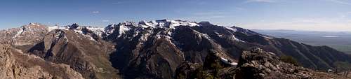
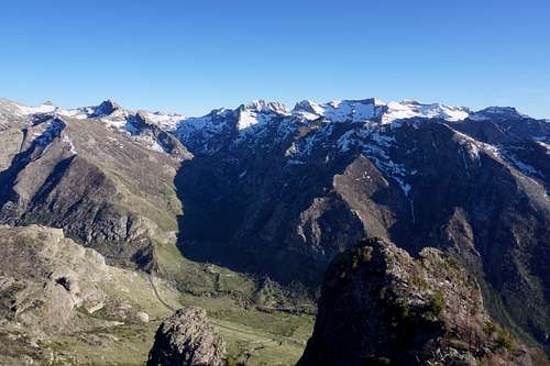
Late May of 2021, a panorama of this core are of the Ruby Mountain Range below. The town of Spring Creek is to the west, right, in this photo.
Getting There
The main way travelers can reach parking to begin on a journey up to Lamoille Peak is via Interstate 80 to Elko, NV, which is immediately off of the interstate. People most often take either the East Elko exit or the Downtown Elko exit. If taking the East Elko exit, one simply needs to turn toward downtown, take a right on Idaho Street, and then turn left on 12th Street. Then turn left at the stoplight and continue up and over Lamoille Pass. Keep going straight toward the Ruby Mountains on the highway. A traffic circle will be several miles down this road. Get in the left lane once you are approaching it, enter the circle carefully, and take the second turn. Continue on until you see a 35mph sign and signs for the town of Lamoille and the Lamoille Canyon Scenic Byway. Turn right just after the 35 mph sign. This quickly becomes national forest territory and one of the most impressive scenic byways in Nevada (it does end in a loop parking lot after approximately 12 miles). But the parking to get to Lamoille Peak is only a mile or so in to the canyon. Pass the campground and recreation area to the right (just after passing the Ruby Dome Ranch gate), and the big parking area on the right of the road is for Talbot Trail. The alternate route is only a couple parking areas beyond Talbot Trail parking.
For travelers traveling from the Downtown Elko exit, simply turn south on Mountain City Highway, and continue down to Idaho Street. Drive through downtown on Idaho Street and then take a right on 12th Street. Follow directions as outlined above.
Route
Two main options exist in terms of getting up to Lamoille Peak. The first and perhaps most traditional way is via Talbot Trail. The Talbot Trail leads around the north side of this stretch of mountains from a parking area immediately off of the scenic byway, just inside the mouth of Lamoille Canyon (it is the semi-circular parking area that is visible in top-left photo below). Some people take this trail and then head up the mountainside once they feel they're closest to the peak.
The second way to the peak is via a more direct route up the south face of the mountain. From the Talbot Trail parking area hikers can begin more of a bushwhacker's ascent higher and higher up the mountain by staying to the right (east) of the ravine that will be right in front of them when looking north from this parking area (see top-left picture below and note the ravine just to right of center). They'll inevitably find the summit that way.
Lastly, farther into the canyon are other pull-offs right beside the road that provide enough space to park for the day and head up the mountainside. Going these ways up will be less direct and may feel disorienting at times.
The top-left picture in the following collage shows the Talbot Trail parking area within direct view of the peak. The top-right photo is a northeast view of the north end of the Rubies and the farther-away East-Humboldt Range beyond. Bottom-right is looking nearly due south from the peak toward the right fork of the canyon, and bottom-left is looking southeast where Thomas Peak and Verdi Peak are both within view.
 |
 |
 |
 |
On the way up the south face of this mountain is a false summit that many will think is actually the top of the mountain. It is not. Here's a look at the false summit.

Another quarter of a mile or so beyond is the true peak.
Red Tape
No red tape besides abiding by open flame rules during the driest months (a fire in 2018 raged miles into the canyon). Besides this, abiding by the "Leave No Trace" code of ethics is always a must for explorers.
When to Climb
One can climb up to Lamoille Peak any time of year, though of course wintertime will almost always require one to use snow shoes for an ascent given that snow drifts can collect in certain gulleys, resulting in knee-to-waste-deep posholing.
Camping
Adventurers can camp in a multitude of places in this area. Nice meadows exist all around the mountain both closer to the road and farther up from it.