
-
 28127 Hits
-
 80.49% Score
-
 12 Votes
|
|
Mountain/Rock |
|---|---|
|
|
40.01370°N / 77.3661°W |
|
|
Cumberland |
|
|
Hiking, Bouldering |
|
|
Spring, Summer, Fall, Winter |
|
|
1729 ft / 527 m |
|
|
Overview
Lewis Rocks (aka "Rock City") is a fairly popular bouldering and scrambling area in southern Pennsylvania. The trail begins near where Mountain Creek and Tumbling Run intersect and is nearly flat for the first 10 minutes. As you wind through a forest of ash and oak trees, the trail is lined in places by Pennsylvania's state flower, the Mountain Laurel.As you ascend, a series of trails runs parallel to Tumbling Run; it doesn't matter which way you go, as long as you always keep the stream on your left as you ascend. It's obvious why they call it Tumbling Run once you see the number of small pools and waterfalls along the way. As you ascend, the trail gets steeper and rockier, and terminates at Lewis Falls.
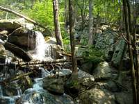 A partial view of Lewis Falls with the climber's trail visible on the right.
From the top of Lewis Falls, find the climber's path immediately to your right. Follow the climber's path to a series of rocky formations on top of the ridge line. The true summit of Lewis Rocks can be found at the third large, rocky outcropping. From the summit, you get nearly unobstructed views of a large portion of 70 mile long South Mountain.
There are numerous (I've read anywhere from 35 to 49) different bouldering problems at Lewis Rocks. Multiple guide books, available online and in local climbing gyms in Pennsylvania, detail the different routes. Routes run from 10 feet to approximately 40 to 50 feet on some of the highballs. Route difficulty begins at VB for beginners, however, there are a wide variety of technical problems for climbers of all skill levels.
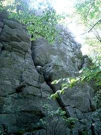 One of the many rocky outcrops at Lewis Rocks.
Roundtrip distance is approximately 3.5 miles, with roughly 900 feet of elevation gain. Further information can be obtained on the Dickinson USGS quad map.
History and geology of the area
Lewis Rocks is named after the legendary 19th century bank robber, the Robin Hood of Pennsylvania, David Lewis. Lewis was known to rob the wealthy and spread his ill gotten gains amongst the poor. It is widely believed that Lewis buried some of his gold in one of three places, one being within eyesight of the Bellefonte Jail where he was imprisoned and later died.Lewis Rocks is a series of rocky outcrops called erosional remnants, consisting of quartzite layers and gneiss that date back to the Cambrian age. A large percentage of the rocky outcrops across Pennsylvania are composed of this material.
The rocky outcrops of Lewis Rocks are consistent with other popular areas in the vicinity such as: Hammonds Rocks, Pole Steeple, Sunset Rocks, Chimney Rocks, and Rocky Knob.
Getting There
Lewis Rocks is accessed easily from either Chambersburg or Gettysburg. The only difference is the first step:From Chambersburg (I-81): head east on Route 30 for approximately 10 miles to Route 233. (signs also call it Pine Grove Road) Turn left at the intersection.
From Gettysburg (Route 30): head west on Route 30 for approximately 15 miles to Route 233. (signs also call it Pine Grove Road) Turn right at the intersection.
Once on Route 233 North (Pine Grove Road), drive approximately 9.5 miles to a well marked gravel turn off on the left side of the road. The turn off is just a few feet beyond a sign indicating the Adams County/Menallen Township and Cumberland County/Southhampton Township border. There is parking for about six to seven cars comfortably, maybe eight or nine if they're all snugly parked compact cars.
 The obvious parking area for Lewis Rocks
Red Tape
Ahhh, red tape. Depending on who you consult, this is a complex issue in this area. Lewis Rocks is a part of the Tumbling Run Game Preserve, a privately owned hunting area. The reserve is entirely contained within Michaux State Forest. There is a well defined parking area, as well as a very well defined trail. There is signage on one side of the creek that indicates no trespassing, however, based on the location of the signage, I would assume as long as you stay on the hiker's right side of the creek, that you'll be ok.There is a small vocal minority (I've counted two people total) that claim permission is required to hike in this area. However, the bulk of my research indicates that as long as you leave no trace, respect the land, and are aware of the hunting seasons, that you may hike with no worry.
If there was contact information for the Tumbling Run Game Preserve, I would call/email/write and clear up the confusion, however, no contact information can currently be found online.
You may be able to get further information from the Michaux State Forest.
You can also contact the ranger for the Michaux State Forest at (717)352-2211.
There is no permit required to park in the pull off.
Last but not least, and I can not stress this enough- if it's hunting season, either hike somewhere else or BE SURE to wear hunter's orange.
 Access issues? Depends who you ask.
Camping
As this is within a game preserve, camping is most likely prohibited. There are zero established campsites anywhere along the trail or at the base of the rocks.External Links
Michaux State ForestInformation on Lewis Rocks from Rockclimbing.com
Further information on the Robin Hood of Pennsylvania, David Lewis.