Page Type Page Type: Mountain/Rock
Location Lat/Lon: 38.88470°N / 120.1873°W
Additional Information Elevation: 9441 ft / 2878 m
Sign the Climber's Log

Overview

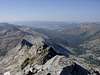
Known by the locals as Little Pyramid it is marked as 9441 on the Desolation Wilderness map. It is not a walk up and lies between 3 drainages. What makes the peak so interesting is that it looks like a better pyramid than Pyramid itself and it makes for a great loop day hike. Once away from the lakes you are unlikely to see many people and depending upon the time of the year the wildflowers can be beautiful.

The mountain lies between Island Lakes and Tyler Lake in Desolation Wilderness and looks down into the headwaters of the Rubicon. It is easily accessible from the Wright's Lake trail heads.

Climbing the mountain is an easy class 2. Total mileage for the trip is just over 9 miles with nearly 3000 feet of elevation gain total if done as a loop from either clockwise or counterclockwise direction.

Getting There

Drive east on hwy 50 from Placerville past Kyburz. At the 5000' altitude sign continue for 1.5 miles and turn left onto Wrights Lake Road. The sign is frequently torn down by a disgruntled cabin owner. From Lake Tahoe westbound if you miss the turn and see the 5000 ' sign do the same after turning around. Drive to the information sign at the end of the lake. At this point you need to make your decision on the route you are planning to take. If you take the Island Lakes route, turn right and continue to the end of the road where there is a parking lot. The trail head is just past a locked gate. Follow the signs to Twin, Island and Grouse Lake.

Red Tape

A permit is required to enter Desolation Wilderness and group size is limited to 12. It is obtainable at the trailhead. Overnight camping is by reservation at the USFS.

When To Climb

July to September assuming the roads are open.

Camping

Camping is allowed at Wrights Lake campground or in the wilderness

Additions and CorrectionsPost an Addition or Correction

Viewing: 1-1 of 1
DaveWillmott

DaveWillmott - Jun 7, 2009 4:43 pm - Hasn't voted

Hike Length

The route outlined is 10 miles and 3000 feet of elevation gain. One can obviously make it a longer trip by climbing up from the southeast face from the east side of Island Lake, or taking the ridge line from the summit to Rockbound pass and back down the Rockbound Pass trail.

Viewing: 1-1 of 1


Children

Children

Children refers to the set of objects that logically fall under a given object. For example, the Aconcagua mountain page is a child of the 'Aconcagua Group' and the 'Seven Summits.' The Aconcagua mountain itself has many routes, photos, and trip reports as children.