
|
|
Mountain/Rock |
|---|---|
|
|
47.03670°N / 121.53327°W |
|
|
Pierce |
|
|
Hiking |
|
|
Spring, Summer, Fall, Winter |
|
|
5080 ft / 1548 m |
|
|
Overview
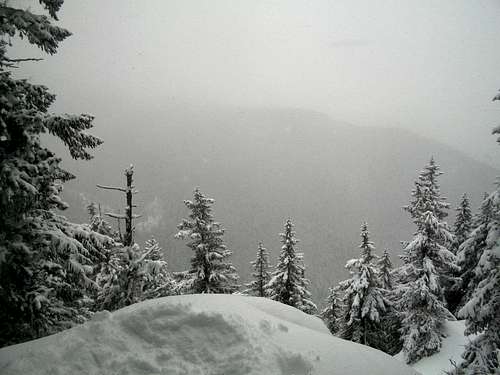
Little Ranger Peak located just north of the Mount Rainer National Park is a fairly popular hiking destination. There are number of places along Ranger Ridge that provided great views of the mountains to the south. There are a number of different trailheads that each provided a Class 1 route to the summit of Little Ranger Peak. Two of these routes are from Highway 410 these routes are the longest of the route. One comes from the northwest side of the mountain while the othr comes from the southside and goes through a number of long switchbacks in order to catch the summit plateau. There are views just west of the true summit. And the summit cairn is located on lip that looks out to Mount Rainier. Little Ranger Peak can also reachs from the north as well.

Because all the ways up to summit are YDS Class 1, this mountain makes a good late season hike (November and December) when the snow is just starting to fall. Once full winter conditions route finding heading up the switchbacks might be a little tough. Still though the one thing that mountain that many other winter summits have a shelter on top just in case of an emergancy bivy.
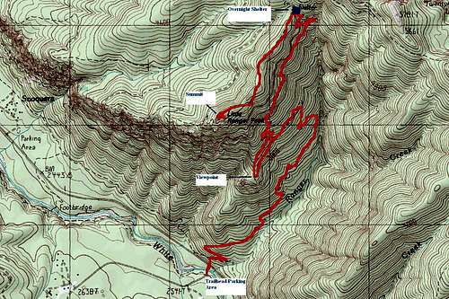
The way we took was from the Little Ranger Trail. The trail itself rises at a very gradual grade and is ideal for a beginning backpacking trip. The trail rises to a viewpoint at 2.6 miles off to the west. The trail then continues all the up it gradual switchbacking way to the shelter. From there a spur trail goes down Ranger ridge to the true forested summit. You will know you hit the true summit because once you have past it you will have hit an opening with a view and then the trail goes downhill on switchbacks.
A map of the winter route up Little Ranger Peak
Getting There
VIA THE NORTHSIDE:From 410 take FR 70. From there turn on FR 72. From there turn on FR 7250. This trailhead will only be open in summer.VIA THE RANGER CREEK TRAILHEAD: Head east on SR 410 from Enumclaw. Between milepost 54 and the Buck Creek Recreation area, make a right on the Ranger Airport road and go accross the bridge, where there will be a trailhead on your left hand side. From ther park and go back the way you came to 410 and cross 410. There is a well established path into the woods up a steep open slope. Take that onto the trail and make a right. Follow that to the sign to the trail that says Little Ranger Peak 2.6 miles. The 2.6 miles will only be to a viewpoint. The true summit will be another 2.5 miles past that get the grade here is extremely gradual.
Red Tape
Northwest Forest Pass requires at all trailhead on Route 410. Remember 410 from November 1st to April 1st requires people to POSSESS chain or risk a $400 fine.Camping
There is a large shelter on the top of the ridge which is in great shape for camping spot. Both in summer and winter this mountain can easily reached in the day. But if you are interested in staying the night and maybe exploring the area. This a very convient place to stop. I will likely be back and stay here this summer.
External Links
This web will have a great read on the local weather in the region.Another trip report mentioning Little Ranger
A very localized weather forecast of the region