Lost Pond Peak RECON
User "Catamont" and I hooked up on the SummitPost forum after Mark shared his report of his first attempt at this truly trail-less peak. Lost Pond Peak looks like a volcano with its hidden pond on top. There are no vantage points in this High Peaks Region that offers a view of the pond. The only way to see it is to bushwhack up the 3850 feet. All of the trip reports I read on this peak, many of them failed attempts, talk about the dense vegetation and blow down, making this climb a rarely attempted challenge. So that made me want to try it even more.
I arrange to meet Mark at the Adirondack Loj parking lot at 0730. It's a 4 hour drive (210 miles) for me so I left the house at 0300 in a heavy rain with a solid 3.5 hours of sleep. The rain soon changed to thick wet snow making driving on the windy mountain roads a real challenge - at times I needed to drop it into 4 wheel drive and keep it at no more than 30 mph. Despite the difficult driving conditions I managed to get to the Loj only 20 or so minutes late. We were on the trail around 0815. Temps were seasonally warm - just around freezing or slightly higher. Skies were overcast. Dressing for these warm conditions is always a trade off - you don't want to over dress. I sported a new pair of 686 waterproof bottoms, two thin poly shirts, a rain shell, fleece hat, gloves, and a sturdy pair of waterproof leather Merrill boots. The boots were brand new hand-me-downs and perform well except for a tendency to blister my right heel. I've successfully avoided this in the past with moleskin which I put on both heels. Over the boots I wore gators and on the boots I wore microspikes.
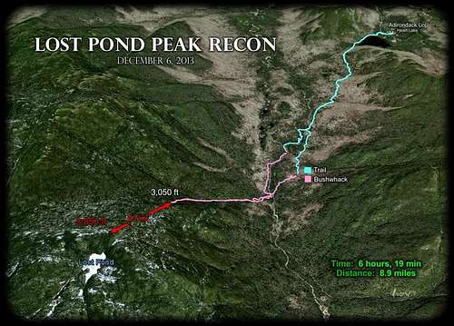
The first 2.5 miles are on the Indian Pass Trail. I felt a blister coming on so we opted to cross the Indian Pass Brook earlier than planned so we could stop at the lean-to on the opposite side. The brook was partially frozen and flowing good from the thaw. The brook is probably 30 or so feet wide and up to two feet deep. There are many large boulders in the brook and finding enough of them close together was not too difficult - but not for the faint at heart. We took a short break the lean-to and I doubled up the moleskin on my right heel. Then we were off through the forest - following the brook towards the drainage we intended to use as our route to the peak. I placed key waypoints in my GPS before hand to guide us to the bottom of the drainage and salient points along the way. Progress through the thick trees and blow down was slow. At times (quite often) you were forcing yourself between short pine trees so thick you could not see the hiker 4 feet in front of you.
We made it to the drainage which was moving a lot of water. Crossing would require locating suitable rocks to hop and was not that difficult. Now we were climbing towards the peak's waypoint while keeping the sound of the drainage creek nearby. Again we ran into some thick foliage and blow-down but not terrible - plus there were also quite a few areas where it was relatively clear. We proceeded up until our predetermined turn-back time of 12 noon. Dark comes early in the woods - around 4ish. So we didn't want to exit in the dark. In the end we reached 3050 ft in elevation (peak = 3850) and fell short of our goal by 0.7 mi. The return trip was much easier for obvious reasons but by this time I was confident that I had a good blister going and walk became painful. So it was a good time to turn around. We made good time getting out and reached the parking lot before 1500. Distance for the day was 8.9 mi in 6 hours, 20 minutes.
We knew going in that there was a good likelihood that we would not reach the peak. The secondary goal of the day was to reconnoiter this as the preferred route - that we did achieve. So our Lost Pond RECON a fun success. Hopefully, Mark and I can complete the climb when the days are longer. Until then, I'll just have to enjoy the video I took (to be posted at a later date) and the Google Earth images I created:
https://www.dropbox.com/sh/a9j3haoj0vjpv20/rLFRYg0YrG
Here's an interesting article Catamont sent me written by George Marshall - Lost Pond


Comments
Post a Comment