
-
 6993 Hits
-
 81.84% Score
-
 14 Votes
|
|
Mountain/Rock |
|---|---|
|
|
49.81250°N / 125.55806°W |
|
|
Hiking |
|
|
4954 ft / 1510 m |
|
|
Overview
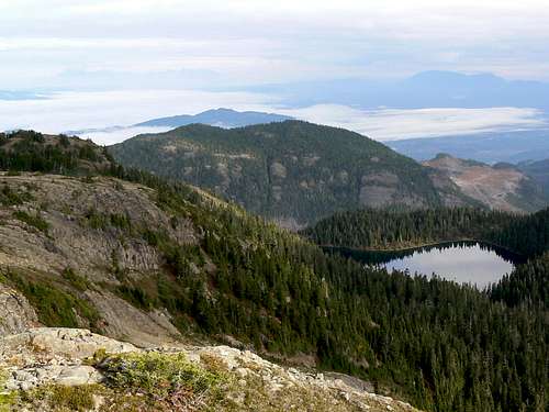 Lupin Mountain south aspect Lupin Mountain south aspect |
Access to this open and scenic area is very easy via high industrial roads and it is a popular destination for hikers, skiers and, somewhat unfortunately, snowmobilers in the winter season.
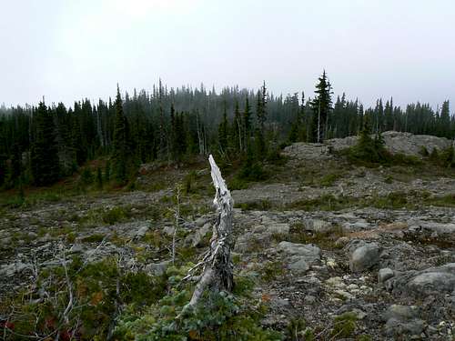
Trees enclose all aspects of the view from Lupin Mountain, except down the northwest ridge. In fact the summit of the mountain is more like an alpine plateau. With no horizon to work with, some patience may be needed to locate the true summit given the absence of obvious features and the convoluted terrain. Particularly if the weather is bad, navigation aids will be essential, especially on the descent. Once off the well travelled route to Mts Beadnell and Adrian, there is no trail, cairns or marking of any kind until the summit cairn is reached.
Lupin Mountain summit
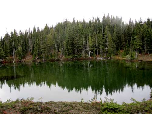
The summit area is quite extensive – I measured over 2 km of travel from the top of the access ridge to the cairn on the high point – and studded with countless pretty tarns, some of them quite large. In fact, the true summit lies just above the largest of all.
The ground is often open and offers pleasant travel. In fact, given the limited views, this might be the only reason for bagging Lupin other than ticking it off.
Although close to Strathcona Provincial Park and in common with the rest of Rodger’s Ridge, Lupin Mountain sits entirely on private land owned by the Timberwest Corporation. Logging reaches far up all accessible sides of the mountain and stops only when the limit of practicality is reached. As a result of this, access is convenient but may sometimes be an issue. Refer to the “Getting There” and “Approach” sections below.
Unsurprisingly, the mountain’s name derives from the abundance of purple mountain lupin found throughout the summit plateau, far down its flanks and in the meadows below.
Getting There
Vancouver Island can be reached directly by air from Toronto, Vancouver, Seattle, Calgary, Edmonton and recently from San Francisco to either Victoria, Nanaimo, Comox or Campbell River and by ferry from Port Angeles to Victoria on The Coho and on BC Ferries from Vancouver to Victoria or Nanaimo. Public transport on the Island is notoriously poor and anyone arriving by air would be advised to rent a car.The approach to Lupin Mountain and the north part of Rodger’s Ridge in general requires you to negotiate steep, narrow industrial roads that have or are being used to log the surrounding mountainsides. However, this particular approach via Granite Road is mostly on main line with no cross ditches and can probably be safely negotiated with a normal passenger sedan.
Closed gates and/or limited hours of access are frequent occurrences on Vancouver Island. This is unlikely to be the case in the present example but, just to be sure, before you go contact Timberwest in order to determine the best plan of attack and current conditions.
Approach
Approach the mountain from the south on the Inland Island Highway 19.From Campbell River at the end of the freeway section of Highway 19 take highway 28 west towards Gold River. Drive for 17 km from the silver bridge at the junction of highways 19 and 28 and find the Quinsam Mine road on the left.
After 3.3 km bear right and leave the road to the mine on Argonaut Main.
Drive a further 16 km southwest past Quinsam Lake to the junction of Argonaut Main with Granite Main and turn left. The onward route is straightforward and the most travelled road is the one to follow at any junctions.
Drive south up the Sihun Creek valley on Granite Main. Access from the vicinity of the small unnamed lake at about N49 48.177 W125 32.974 is very convenient via cut snowmobilers trail to the low saddle on Rodger’s Ridge south of Lupin Mountain. From the junction of Granite and Argonaut Roads proceed as follows:
-At N49 51.025 W125 32.881 keep left
-At N49 49.545 W125 31.867 bear left
-At N49 48.584 W125 32.243 at a prominent junction keep right for the small lake and the north part of Rodger’s Ridge.
-Proceed 2 km from this junction to N49 48.150 W125 33.257 and find a spur on the left.
-As of May 2015 this spur is no longer driveable. Walk up 150 metres to N49 48.095 W125 33.343 and find an obvious use path and a flat spot for one or two tents.
Summit Route
Start from the well used and obvious trailhead at to N49 48.095 W125 33.343 the end of the short spur off the right branch of upper Granite Main under the south aspect of Lupin Mountain.Follow the use path west through the old logging slash and enter the forest above. You will immediately come across the red markers placed by snowmobilers high on trees and VERY obvious signs of their passage in the form of a wide swath of cut trees and bushes. Head south up the path to a lovely series of sub alpine meadows and tarns in no more than 10-15 minutes from where you entered the trees.
 Lupin Mountain TH Lupin Mountain TH |  Rodger's Ridge snowmobilers' track Rodger's Ridge snowmobilers' track |  Lupin Mountain SE aspect Lupin Mountain SE aspect |
From the area of tarns you can see the crest of Rodger’s Ridge above you to the south. Traverse off to the southwest towards the low point on the ridge following flagging and the occasional boot path. Look behind you during this phase and you will spot Lupin Mountain to the southeast from open areas along the way. Aim for the neighborhood of N49 47.478 W125 33.673 where you will find another open tarn filled area. The route up Lupin Mountain diverges from the rest of the Rodger’s Ridge objectives here.
Walk around the tarns and into the forest heading initially northwest for about 400-500 metres. Swing round to the north and make a brief bushy ascent up to the continuation of Rodger’s Ridge.
The ground opens up once above ~1,450 metres and the summit of Lupin Mountain – in fact several candidate high points - can be seen off in the distance to the northeast. Seen from below, the route up Lupin appears to be a simple ridge walk. Once up there, however, the converse is apparent; a large featureless area with lots of places to go and ways to get there. The best plan is to keep going northeast and aim for N49 48.735 W125 33.347 the approximate coordinates of the large tarn right under the summit. Several subsidiary high points will be crossed along the way with quite a bit of up and down. As already mentioned, don’t expect a path, cairns or any other route marking.
 Lupin Mountain summit plateau Lupin Mountain summit plateau |  Lupin Mountain true summit Lupin Mountain true summit |  Descending Lupin Mountain Descending Lupin Mountain |
Once the large tarn is in sight, go down and round its left bank and then turn back west and bushwhack up through the trees to the summit platform. It’s the only one with a cairn (we tried several) just 150 metres map distance from the tarn.
Return to your vehicle the way you came up.
Route summary return from the snowmobilers’ trailhead:
Distance: ~ 10 km
Net elevation gain: ~ 310 metres
Total elevation gain: ~ 500 metres
Approximate time: ~ 4-5 hours return
Lupin Mountain summit "view" east
As always a Garmin/Mapsource tracklog is available for the approach and climbing route on Lupin Mountain. As a general rule I don't make routes universally available as GPX files but just ask for it via an email or PM.
Red Tape/Safety Considerations
Although there are no fees to pay or forms to fill in, a pre-trip conversation with Timberwest regarding access might be in order.As of October 2010, the current situation is as follows: Argonaut/Granite Main. No restrictions that I know of currently in place.
I regret that we did not check for cellular service from the summit of Lupin Mountain or anywhere along the way.
This is private land and there’s nothing in the way of an intentions system. Make sure, therefore, that you have left a detailed trip plan with someone responsible. The RCMP and the appropriate SAR agency will respond in an emergency but it is up to you to have the mechanism in place that will initiate the call-out process if it becomes necessary.
Camping
I know of no restrictions on camping along the length of Rodger’s Ridge.The few folk who bother going up Lupin Mountain probably do so as part of a day trip, although the extensive summit plateau would offer wonderful camping for those who enjoy this for its own sake.
If you do decide to camp remember that fires are strictly prohibited, so you must pack a stove. Bear and cougar frequent the mountains and forests of Vancouver Island – scat was everywhere along Rodge’s Ridge - so proper back country methods – hanging food bags out of reach, cleaning up all cooking scraps, good toilet practice etc – are essential. Giardia is well documented throughout the Island, so boil or treat all water.
Weather
EastWest
Useful Links
For more information refer to Island Alpine – A Guide to The Mountains of Strathcona Park and Vancouver Island, Philip Stone, Wild Isle Publications, 2003, ISBN 0-9680766-5-3For general backroad information and directions get hold of a copy of Backroad Mapbook. Volume III: Vancouver Island
Don't go on any Island trip without checking out Lindsay Elms excellent Beyond Nootka website.