
-
 1617 Hits
-
 75.81% Score
-
 6 Votes
|
|
Mountain/Rock |
|---|---|
|
|
34.07402°N / 116.14178°W |
|
|
Trad Climbing |
|
|
Spring, Fall, Winter |
|
|
Overview/Approach

Gracing the front page of Miramontes 2011 Joshua Tree climbing guide book is an incredible image of Firewater Chimney. He and Wolverine Publishing thought the route to be so aesthetic; they included yet another full page photo of Firewater Chimney on page 417. Firewater Chimney is located on a feature known as the Arrowhead. Arrowhead lies in the Valley of the Kings which centers around a feature named the Helmet. The Lynch Crag is a dark colored 90’ high slabby feature to the northwest of the Helmet and almost directly across (west) the valley from the Arrowhead (15 minutes).
 Eraserhead, 5.9
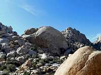
Eraserhead (5.9) (photo) is a fairly good route that follows a steep crack about 2/3rds of the way up Lynch Crag before encountering the slab which is bolted to the summit. Powered by English (5.11d) is a three stared sport route in Miramontes guidebook to the right of Eraserhead that does not reach the summit of Lynch Crag. All of Lynch Crag's routes face south-southeast allowing for a stellar warm-up opportunity before heading across the valley for the most sought after objective in this area, Firewater Chimney. Steve and Angie Sutton developed most of these routes in 1992.
This entire area is centered around a definitive feature named the Helmet located in a small valley at the edge of North Wonderland known as the Valley of the Kings. Valley of the Kings is best approached by a 1000’ gain up and out of Indian Cove via Rattlesnake Canyon. Rattlesnake Canyon offers one of the most, if not the most, remote and pristine hikes in all of Joshua Tree National Park. Once you turn left (southeast) to scramble up a boulder filled drainage to reach Valley of the Kings, you more than likely will have this section of the park to yourself. There is an alternative, longer, approach through the North Wonderland area.
Park at the Rattlesnake Canyon trailhead (east of Indian Cove). Hike up canyon on the left side of the waterfall/drainage on the whitewashed granite. Follow the canyon as it bends right (southwest). Before you exit the canyon and scramble up the left side, the total hike from the trailhead might be 30 minutes +/-. There are two (large) boulder filled gullies on the left at yet another sharp bend right just past a feature known as Rattlesnake Buttress up high and left. Take the first such gully which in February had running water. The second one was dry in February. They both work, but the first one will allow faster travel through less technical terrain. As you hit the top of the east canyon wall, an obvious feature known as the Helmet (photo) will come into full view. Take a short slot slightly left which opens up to Valley of the Kings on the other side. Head straight north for the brown walled 90’ tall feature up on the left side of the valley. The route Eraserhead is actually made up of two cracks forming a “T” and is the left most route on this feature.
Route Description(s)

