La montagna chiama i suoi figli, ed essi rispondono fedelmente al suo appello…
Osvaldo Cardellina, Diario alpinistico, 1964-65
Page texts: @ OsvaldoCardellina"Osva", passed away on May 2, 2022. Page owners: Christian Cardellina e Osvaldo Cardellina. Any updates from September 12, 2022: Antonio Giani, page administrator, friend and climbing companion.
Testi della pagina: @ OsvaldoCardellina "Osva", scomparso il 2 maggio 2022. Proprietari pagina:Christian Cardellina e Osvaldo Cardellina. Eventuali aggiornamenti dal 12 settembre 2022: Antonio Giani, amministratore della pagina, amico e compagno di salite.
Old Northern Overview
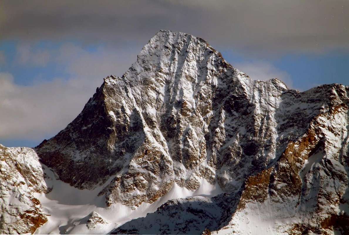
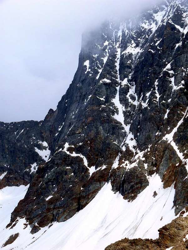
This large wall dominates Aosta Town above 3.000 meters. Facing North has a height at its highest point of over 750 meters, while it is large for almost two kilometres, between its Edge North-northeast, which separates it from the vertical East Wall above Blantsette Glacier into Les Laures Vallon, and his part in the Western below the Mont Ròss de Comboé or large West Shoulder (3.301m), where it loses somewhat of height and steepness. But his point of highest elevation is between the Top (3.559m) and a large rocky ridge that like a "big Breast or Udder" drops to split the two Glaciers Eastern and Western Arpisson up to the altitude of 2.800 meters, before a characteristic rounded and alluvial fans in altitude of 2.826 meters (See photo in bottom near the number 12). So in this area the wall is over 750 meters high; but this large spur does not come directly from the Vertex, but originates at the Top of the Black Triangle (3.378m), great forepart vertical shaped black triangular shield becomes detached from the wall itself, that is, between the edge of the above and a steep gully rocky glacial-called "Couloir Ghost" by climbers. But the "true" North is completely to the West of this sector definitely facing North. Concave it relaxes at first like a trapezoid inclined forming a lozenge ending as irregular parallelepiped gradually proceeds towards the West in the direction Carrel Hill (2.912m) at the adjacent Federigo Bivouac (2.912m). But the same does not reach the same, as contained by a secondary ridge, which is separated from the Northwest of Mont Ròss just below a characteristic reddish tooth (3.150m; Red Tower by buxlex in SP) to arrive at the North Pond Peckoz (2.873m) now in the Arpisson Vallon.
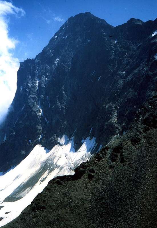
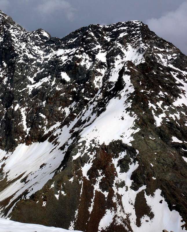
North Face from West-northwest 1978, by Osw
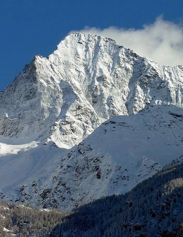
Precisely against this margin runs out of the wall, contained in part higher, over the tooth, the Northwest Ridge of Mont Ròss and then from the West, that the same reaches the Little Emilius (3.342m) and then the Vertex. The wall is "holds" on twin pillars separated by a large Central Channel, accompanied by another similar lines immediately to the West of the pier right or West, that constitute a perfect symmetry. This side from right to left is more towards the North-northwest, while the gully to the right and in the direction of the Little Emilius down a wall facing North and far more limited his right to an edge arched. In addition, gradually losing height, stretches an area less steep that the Little Emilius reaches the ends Western foot of Mont Ròss de Comboé. A third gully salt oblique "cutting" the wall from the base, here in the altitude of 2900 meters, reaching the North-northeast Edge just above the Black Triangle and at that particular "notching shaped closed hand" about 3.400 meters, making it even more geometrically clear design of this face. All three couloirs are greatly exposed to falling rocks, especially the last one, because its morphology, is intended as a funnel, to convey everything that comes from the Top. This factor certainly makes the wall more difficult and dangerous for this specific reason has never recorded a large attendance by climbers; just go up to the nearby Becca di Nona to hear the frequent discharges that with their dull rumble distort the same blackening the Glacier Arpisson. Nevertheless, it has attracted the attention of long-time climbers, especially but not only local, in search of strong emotions and have a good Spirit of Adventure. We see its history.
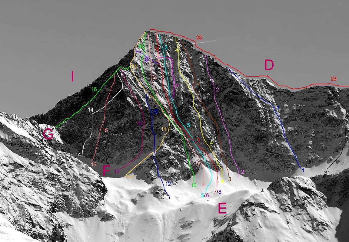
North Wall All Routes since 1875 until 2006, by Antonio
Questa grande parete domina la Città d'Aosta dall'alto di 3.000 metri. Rivolta a Settentrione presenta un'altezza nel suo punto massimo di oltre 750 metri, mentre é larga per quasi due Kilometri, compresa tra il suo Spigolo Nord-nordest, che la separa dalla verticale Parete Est sopra il Vallone delle Laures, e la sua parte più Occidentale al di sotto del Mont Ròss de Comboé o Spallone Ovest (3.301 m), dove perde alquanto sia d'altezza che di ripidezza e conseguentemente d'interesse. Ma il suo punto di massima elevazione trovasi tra la Sommità (3.559 m) ed un costolone roccioso che a guisa di "Mammellone" scende a dividere i due Ghiacciai Orientale ed Occidentale di Arpisson fino alla quota di 2.800 metri circa, prima d'una caratteristica e tondeggiante conoide di deiezione a quota 2.826 metri (Vedi nella foto sopra presso il numero 12). Quindi in questo settore la parete supera i 750 metri d'altezza; ma questo grande sperone roccioso non proviene direttamente dal Vertice dell'Emilius, bensì trae origine presso la Sommità del Triangolo Nero (3.378 m), grande avancorpo verticale che a forma di nero scudo triangolare si distacca dalla parete vera e propria, cioé tra lo spigolo di cui sopra ed un ripido canalino roccioso-glaciale detto "Couloir Fantasma" dagli alpinisti locali. Ma la Parete Nord vera e propria si trova completamente ad Ovest di tutto questo settore, decisamente rivolto a Settentrione. Di forma concava si distende dapprima a guisa di trapezio inclinato formando una losanga terminante a mò di parallelepipedo irregolare a poco a poco che procede verso Ovest in direzione del Colle Carrel (2.912 m), presso l'attiguo Bivacco Federigo Zullo (2.912 m). Ma la stessa non lo raggiunge, poiché contenuta da una crestina secondaria, distaccantesi da quella Nordovest del Mont Ròss de Comboé ed appena al di sotto d'un caratteristico dente rossiccio (3.150 m; Torre Rossa o Red Tower per buxlex in SP) per giungere a Nord del Laghetto Peckoz (2.873 m). Proprio contro questo margine s'esaurisce la parete, contenuta invece nella parte più in alto, sopra il dente, dalla Cresta Nordovest del Mont Ròss e poi da quel grande Spallone Ovest, che dal medesimo raggiunge il Piccolo Emilius (3.342 m) e quindi il Vertice.
La parete si "regge" su due pilastri gemelli separati da un Canalone Centrale, accompagnato nelle linee da altro similare subito ad Occidente del Pilastro di destra od Ovest, che le configurano una simmetria perfetta. Questo lato da destra verso sinistra é più rivolto verso Nord-nordovest, mentre dal canalone di destra ed in direzione del Piccolo Emilius scende una parete decisamente più rivolta a Settentrione e limitata sulla sua destra da uno spigolo arcuato. Oltre, perdendo progressivamente d'altezza, s'allunga un settore meno ripido che dal Piccolo Emilius raggiunge l'estremità Occidentali ai piedi del Mont Ròss de Comboé. Un terzo canalone sale obliquo "tagliando" la parete dalla base, qui in altitudine di 2.900 metri circa, raggiungendo lo Spigolo Nord-nordest appena al di sopra del Triangolo Nero e presso quella particolare "dentellatura a forma di mano chiusa" a circa 3.400 metri, rendendo ancora più geometricamente evidente il disegno di questa faccia. Tutti i tre canali sono esposti notevolmente alla caduta di pietre, soprattutto l'ultimo che, causa la sua morfologia, é destinato, come un inbuto, a convogliare tutto ciò che proviene dall'alto e dappertutto. Questo fattore rende sicuramente la parete più pericolosa che non difficile e proprio per questo specifico motivo non ha mai registrato grande interesse e relativa frequentazione da parte degli alpinisti; basta salire alla vicina "Becca" per udirne le scariche frequenti che col loro sordo rimbombo stravolgono la stessa insozzando il Ghiacciaio d'Arpisson Occidentale. Ciononostante essa ha attratto da lungo tempo l'attenzione degli alpinisti, soprattutto ma non solo locali, in cerca di forti emozioni e dotati di buon Spirito d'Avventura. Vediamone la Storia.
In addition to divide the history of this wall in two parts, where we mentioned in the previous page to all the digression but focusing the discussion on the post-war period, in this new page we take into account, by dividing the same into three distinct periods, only everything you is verified by the "Early Days" until the conclusion of World War II. Diversification arbitrary but logical, since contaddistingue three separate phases very obvious. we called "Phase One or Prehistoric" everything related to the first attempts until after the First World War, with a partial success by the Way in 1897 under the Little Emilius. The second has been called "Phase Academic" and leads to climb on real North Wall, although still not completely in August 16th, 1926 and in August 21th, 1927. Three mountaineers of Aosta Valley, Binel, Chabod and Crétier, to achieve the same; are very young and by the time they are not "Academic" of the C.A.I., but it will become. Now they sign, Binel and Crétier, after an exhaustive article on "RM 1929", pages 270-2, as belonging to Section S.U.C.A.I. Turin and Section C.A.I of Aosta, while Renato Chabod already gravitates in "Olympus" of the Italian Mountaineering. Then when the interest decade, moving on the again virgin East Wall, you will have to wait thirteen years to find again of climbing on the same, that is, until 1940, in time to start World War. We called it "Phase of the Warriors", because, unfortunately, not only for the war in place, but even marked by ascents by strong people and fearless, as the Musicologist Prof. Massimo Mila together with the Engineer "Ansel" Falcoz, climb the Central Couloir without the use of the rope (referring to the same difficulties, and never, as he told me the Anselme Falcoz), or as in full Spring of 1942 when the Mountain Guide Aosta and Partisan Giulio Adolfo Ourlaz said "Dulo" (his wife Aurora Wuillerminaz shot by the Nazis), climb on "Great Udder or Breast also Mammellone" between this and the Black Triangle, which most likely was the real goal of the day. Then again the same with the Officer of the Alpine Troops Emanuele Tosana, in the Autumn of that year, he repeated the way of the Central Channel with some variations. Finally nothing until 1967 ...
Oltre a dividere la Storia di questa Parete in due parti, ove nella precedente pagina abbiamo accennato a tutto l'excursus ma focalizzando il discorso sul dopoguerra, in questa nuova prendiamo in considerazione, dividendo la medesima in tre distinti periodi, esclusivamente tutto ciò che s'é verificato dagli "Albori" sino alla conclusione della Seconda Guerra Mondiale. Una diversificazione arbitraria ma logica, poiché contaddistingue tre fasi separate molto evidente. abbiamo chiamato "Fase Uno o Preistorica" tutto ciò che concerne dai primi tentativi fino a dopo la Prima Guerra Mondiale, con una riuscita parziale tramite la Via 1897 sotto al Piccolo Emilius. La seconda é stata denominata "Fase Accademica" e conduce alla salita sulla vera e propria Parete Nord, anche se ancora non in modo completo nel 1926 e nel 1927. Sono tre alpinisti valdostani, Binel, Chabod e Crétier, a realizzare la medesima; sono giovanissimi e per il momento non sono "Accademici" del C.A.I, ma lo diventeranno. Adesso si firmano, Binel e Crétier, dopo un esauriente articolo sulla "RM 1929", pagine 270-2, come appartenenti alla Sezione S.U.C.A.I. di Torino e Sezione di Aosta, mentre Renato Chabod già gravita nell'"Olimpo" dell'Alpinismo Italiano. Poi quando l'interesse scema, spostandosi sulla ancor Vergine Parete Est, si dovranno attendere tredici anni per trovare nuovamente delle scalate sulla stessa, cioè fino al 1940, in periodo d'inizio conflitto mondiale. L'abbiamo denominata "Fase dei Guerrieri", poiché, putrtroppo oltre che dalla guerra, segnata da ascensioni da parte di gente rude ed intrepida che, come il Musicologo Prof. Massimo Mila insieme all'Ingegnere "Ansel" Falcoz, saliva il Canale Centrale senza ricorrere all'uso della corda (rimandando il medesimo alle difficoltà, quindi mai, come mi raccontò il Falcoz), oppure come in piena Primavera del 1942 quando la Guida e Partigiano Giulio Adolfo Ourlaz, detto "Dulo" (la moglie Aurora Wuillerminaz fucilata dai nazisti), saliva il Mammellone" tra questa ed il Triangolo Nero, molto probabilmente il vero obiettivo di quella giornata. Ancora lo stesso con l'Ufficiale degli Alpini Emanuele Tosana, nell'Autunno dello stesso anno, ripeteva la via del Canale Centrale con alcune varianti. Infine nulla fino al 1967 ...
Getting There
BY CAR:
From TORINO, MILANO, etc: Motorway A5. Exit at IVREA or Quincinetto (PIEDMONT).
From IVREA Town: in West (Southern side) to Grand Brissogne, Pollein, Charvensod and Gressan Municipalities. From Courmayeur Resort: in East to Morgex, La Salle, Saint Pierre, Sarre, Aosta Municipalities.
Southern Side:
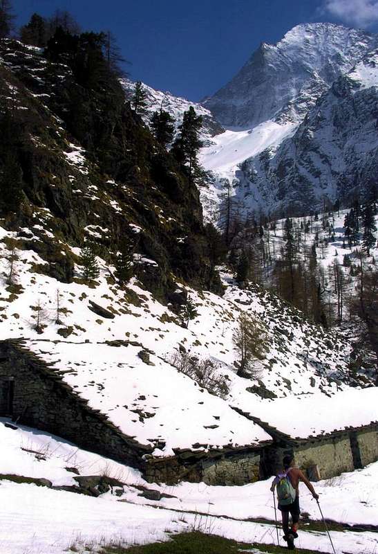
From Grand Brissogne(827m) to L'Arp, dirt road, Les Laures Walloon-Ernesto Ménabreaz Shelter at Lower Laures Lake (2.546m), path-muletrack. From Pollein (575m; secondary road) or from Charvensod (746m; main road and connection) to Martsaouchy Damon-Arpisson Vallon, through dirt road, and to Arpisson Lower and Upper (2.010m) Alpages with path. To Federigo Zullo Bivouac (2.907m), through moraines on Western Arpisson Glacier. From Charvensod to Dard-Comboé-Arbolle Vallons towards Ponteilles(1.697m) Alp/Waterfall, through dirt road, Comboé Alp/Saint Ours Shelter (2.114m), through dirt road, and Arbolle Refuge(2.516m), near Lakes (2.497m), by Chair Lift to Chamolé Station (2.309m), Lake (2.325m) and muletrack. From Charvensod (main road from Pont Suaz 567m) or from Gressan (603m; alternative road) to Tivet, Les Fleurs Hamlets (1.292m, 1.414m) Pila Basin and Pila Resort (1.800m); upper parking 1.850m).
From FRANCE: through the Mont Blanc Tunnel to Entrèves-crossroads to Vény/Ferret Valleys neighbor Courmayeur-Resort. By Little Saint Bernard Pass, closed since November until half May to La Thuile Valley - Pré Saint Didier - Courmayeur. It is not necessary to take Motorway A5: you can drive on SS.26, in the direction of AOSTA - IVREA - TURIN.
BY PLANE:
Aeroporto "Corrado Gex" Saint Christophe (Aosta).
Very Old Courses
"Arpisson Vallon, here are parties, here have returned in 1897", by emilius
Phase One: "The Prehistorics"
From "C.A.I. Bulletin 1878", a first attempt is made in the summer of 1875 by Martin Baretti, Luigi Bruno with Augusto and Vittorio Sibille Mountain Guides of Val di Susa. In the report, actually a bit confusing, it is called West Wall, not existing, and of a retreat to a hundred metres from the Summit, because the ice covering totally rocks. From the description seems more effort on the right side at the Little Emilius (3.342m), because is a via that will be held on 30th August 1897 by Ercole Daniele and Giovan Battista Devalle with Mountain Guides Valtournanche Alessandro and Luigi Pession, after, the previous day, the first climbing on Becca di Seneva. This is the first focused on the same goal, even if made in a sector more marginal than the wall itself; even more is the descent of the September 17th, 1902 by the Abbé Joseph Maria Henry with Mountain Guide Charvensod Grégoire Comé. After covering the West Ridge, fall to Carrel Hill to the extreme limit of the Great Shoulder of Mont Ròss, dropping suddenly not difficult between blocks and snowfields up to Glacier West Arpisson. Both ways, belonging to a "was exploratory", were no longer addressed, but the way in 1897 is far from easy. When in 1906 the Abbé climb the North-northeast Edge from above the Triangle, given the difficulties faced seemingly insurmountable on the North-Northeast Corner, observing below search an escape downhill; considers it feasible along the oblique gully, then the climbing have successfull and he will forget to think to the North Face ...
Fase Uno: "I Preistorici"
Da "Bollettino C.A.I. 1878", un primo tentativo viene effettuato nell'estate 1875 da Martino Baretti e Luigi Bruno con Augusto e Vittorio Sibille della Val di Susa. Nella relazione, a dire il vero un pò confusionaria, si parla di Parete Ovest, inesistente, e d'una ritirata ad un centinaio di metri dalla Vetta, causa il ghiaccio ricoprente completamente le rocce. Dalla descrizione par più tentativo sul lato destro presso il Piccolo Emilius (3.342 m), per via che sarà realizzata il 30 Agosto del 1897 da parte di Ercole Daniele e Giovan Battista Devalle con le Guide di Valtournanche Alessandro e Luigi Pession. Questo é il primo obiettivo centrato sulla medesima, anche se realizzato in un settore più marginale rispetto alla parete vera e propria; ancora più é la discesa del 17 Settembre 1902 ad opera dello Abbé Joseph Maria Henry con la Guida di Charvensod Grégoire Comé. Dopo aver percorso la Cresta Ovest, rientrano al Colle Carrel al limite estremo dello Spallone del Mont Ròss, scendendo un tratto non difficile tra blocchi e nevai fino al Ghiacciaio Occidentale d'Arpisson. Entrambe le vie, appartenenti ad un'"era esplorativa", non son state più affrontate, ma la via del 1897 é tutt'altro che facile. Quando nel del 1906 l'Abbé sale lo Spigolo Nord-nordest un'occhiatina, da sopra il Triangolo sul fondo, la getta, prospettando, viste le difficoltà che incontrano apparentemente insormontabili sullo Spigolo Nord-nordest, una via di fuga in discesa; la ritiene possibile lungo il canalone obliquo, poi la salita andrà a buon fine e lui si dimenticherà di pensar alla Nord ...
Routes Description
Phase Two: "The Academics"
So they think instead three young Aostans in 1926: are Lino Binel, Renato Chabod and Amilcare Crétier, which go up to mid-August at the old Shelter Baron Peckoz Beck decided to make a new route and most complete, twenty-nine years later. The next day at 4.35 to 5.00 start attacking the wall in the middle of the two pillars. Climbing for seven hours, keeping the left edge of the Central Gully, ie on the inner margin of the East Pillar, until large plaques icy convince them, not wanting to get to cut steps on ice, to "escape" on the left to reach the edge North-northeast. There they meet a group of roped climbers Biella led by Alessandro Martinotti, and together they raggiungon the Vetta for 13.10. The humiliation of not being able to make the climb integral provokes them, wherefore rimandan everything to the next season. But when you find August 20, 1927 at Carrel Hill are but two. Of Chabod, "attracted to other mountains" you can not see not even a shadow. But the next day still are in three: two of mankind and the third an animal with the company of a nice marmot captured by Amilcare bare hands; even she will climb the North rubbing into the backpack. Rising at 4.10 hours and 4.45 to have the bergsrunde. To 11.20 hours are in Peak, with some small variants than the year before. They climb the pillar on the cutting Eastern with exit out on Western Ridge to the 50 meters by the Top and through this they conclude. It is not yet fully complete a climb, going out once there and another here but who is content ...
Fase Due: "Gli Accademici"
Ci pensan sù invece tre giovani aostani nel 1926: sono Lino Binel, Renato Chabod ed Amilcare Crétier, che a Ferragosto salgono al vecchio Ricovero Beck Peckoz decisi compiere una nuova via e completa, ventinove anni dopo. Il giorno appresso alle 4,35 partono attaccando alle 5,00 la parete nel mezzo dei due pilastri. Arrampicano per sette ore tenendosi sul bordo sinistro del Canalone Centrale, cioè sul margine interno del Pilastro Est, fino a quando grandi placche ghiacciate li convincono, non volendo mettersi a tagliare gradini, a "sfuggire" sulla sinistra per raggiungere lo Spigolo Nord-nordest. Lì incontrano una cordata di Biella guidata da Alessandro Martinotti, ed insieme a costoro raggiungon la Vetta per le 13,10. Lo smacco di non esser riusciti a compiere la salita integrale li provoca, per la qual cosa rimandan il tutto alla successiva stagione. Quando però si ritrovano il 20 Agosto 1927 al Colle Carrel non sono che in due. Di Chabod, "attratto da altri monti" non si vede neppur l'ombra. Ma il giorno appresso saran ancor tre: due del genere umano ed il terzo animale con la compagnia d'una bella marmotta catturata da Amilcare a mani nude; farà la scalata della Nord strofinandosi nello zaino. S'alzano alle 4,10 ed alle 4,45 son alla terminale, alle 11,20 in Vetta, con alcune variantine rispetto all'anno prima. Salgono il Pilastro Orientale sul filo ed escon sulla Cresta Occidentale a 50 metri dal Sommo e tramite questa concludono. Non é ancora una salita perfettamente completa, uscendo una volta di là ed un'altra di qua però chi s'accontenta ...
Phase Three: "The Warriors"
But, once here and a beyond, the wall at the maximum point, ie in the Eastern area, is not yet fully overcome. And so will be in 1940, when Anselmo "Ansel" Falcoz with Massimo Mila, along the Central Couloir, will come out even further to the West. And also the Guide Giulio Adolfo "Dulo" Ourlaz with Lieutenant Emanuele Tosana will too to the East, in April 1942, making a great undertaking, will go through the "Mammellone" that divides the wall from the Black Triangle and then conclude from above the Triangle through the North-northeast Corner; Autumn will make a "mixed" via, through a ridge in the center channel with the next crossing left on East Pillar and exiting as the party of 1927. This time frame between the first ascents and those carried out during the years of conflict had been clouded by tragedy that occurred August 25, 1929 when the brothers Alessandro "Dino" and Jean Charrey with Cino Norat fallings on the East Wall in an attempt to carry out the first ascent. The Friulian, but living in Turin, Giusto Gervasutti "The Fortissimo" together the academic Renato Chabod Valsavarenche actually bring June 26th, 1935, but lost because of this climb the "Race" to the North of the Grandes Jorasses or "Wanda ", as he called Amilcare, who in the meantime died in 1933 with Gaspard and Ollietti the Matterhorn after the first ascent of the South-southeast Ridge or "Cresta De Amicis". Here it seems to end the story of these two walls that sees repeat the East by Pietro "Piero "Rosset with Franco Garda in summer 1946 and the first solo by Giovanni Matteo "Agostino" Zulian in September 1961, but the North Wall seems to fall into oblivion.
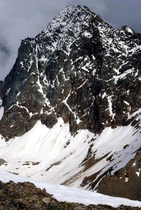
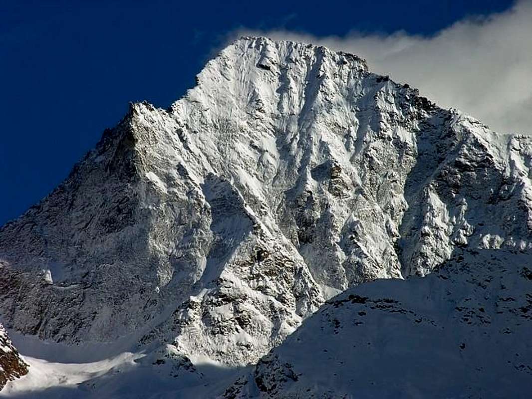
North Wall from North 2005, by Antonio
Fase Tre: "I Guerrieri"
Ma, una volta di qua ed una di là, la parete nel punto massimo, il settore Orientale, non é ancora completamente vinta. E così sarà anche nel 1940, allorchè Anselmo "Ansel" Falcoz con Massimo Mila, percorrendo il Canalone Centrale, usciranno ancor più in là ad Ovest. Ed anche la Guida Giulio Adolfo "Dulo" Ourlaz con il tenente Emanuele Tosana farà ugualmente: ad Aprile del 1942, compiendo una bella impresa, salirà tramite il "Mammellone" che divide la parete dal Triangolo Nero per poi concludere sul Triangolo tramite lo Spigolo Nord-nordest; in Autunno effettuerà una via "mista" attraverso una crestina nel Canale Centrale e traversata a sinistra sul Pilastro Est, uscendo come la cordata del 1927. Questo lasso di tempo tra le prime salite e quelle svolte durante gli anni del conflitto era stato offuscato dalle tragedia che si verificava il 25 Agosto del 1929 quando i fratelli Alessandro "Dino" e Jean Charrey insieme a Cino Norat precipitavano sulla Parete Est nel tentativo d'effettuarne la prima salita. Saranno il friulano, ma torinese d'adozione, Giusto Gervasutti "Il Fortissimo" insieme all'Accademico Renato Chabod della Valsavarenche ad effettuarla il 26 Giugno 1935, perdendo però a causa di quest'ascensione la "Corsa" alla Nord delle Grandes Jorasses o "Wanda", come diceva Amilcare, che nel frattempo cadeva nel 1933 con Gaspard ed Ollietti al Cervino dopo aver realizzato la prima della Cresta Sud-sudest o "Cresta De Amicis". Qui par concludersi la storia di queste due pareti, che vede ripetere la Est da Pietro "Piero" Rosset con Franco Garda e la prima solitaria di Giovanni Matteo "Agostino" Zulian nel Settembre 1961; ma la Nord sembra proprio cadere nel dimenticatoio.
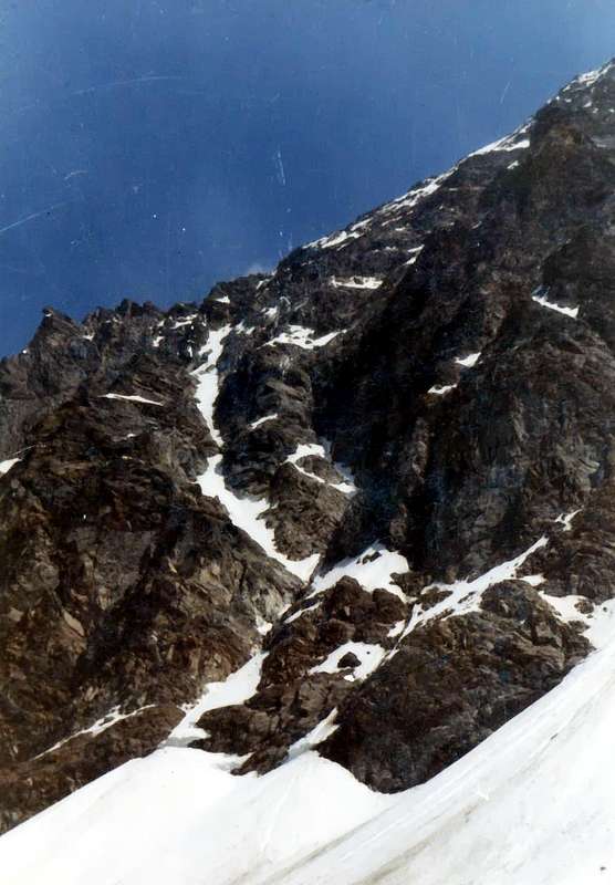
Left Sector & Black Triangle from North or Arpisson Vallon 2006, by emilius
Illusions from North
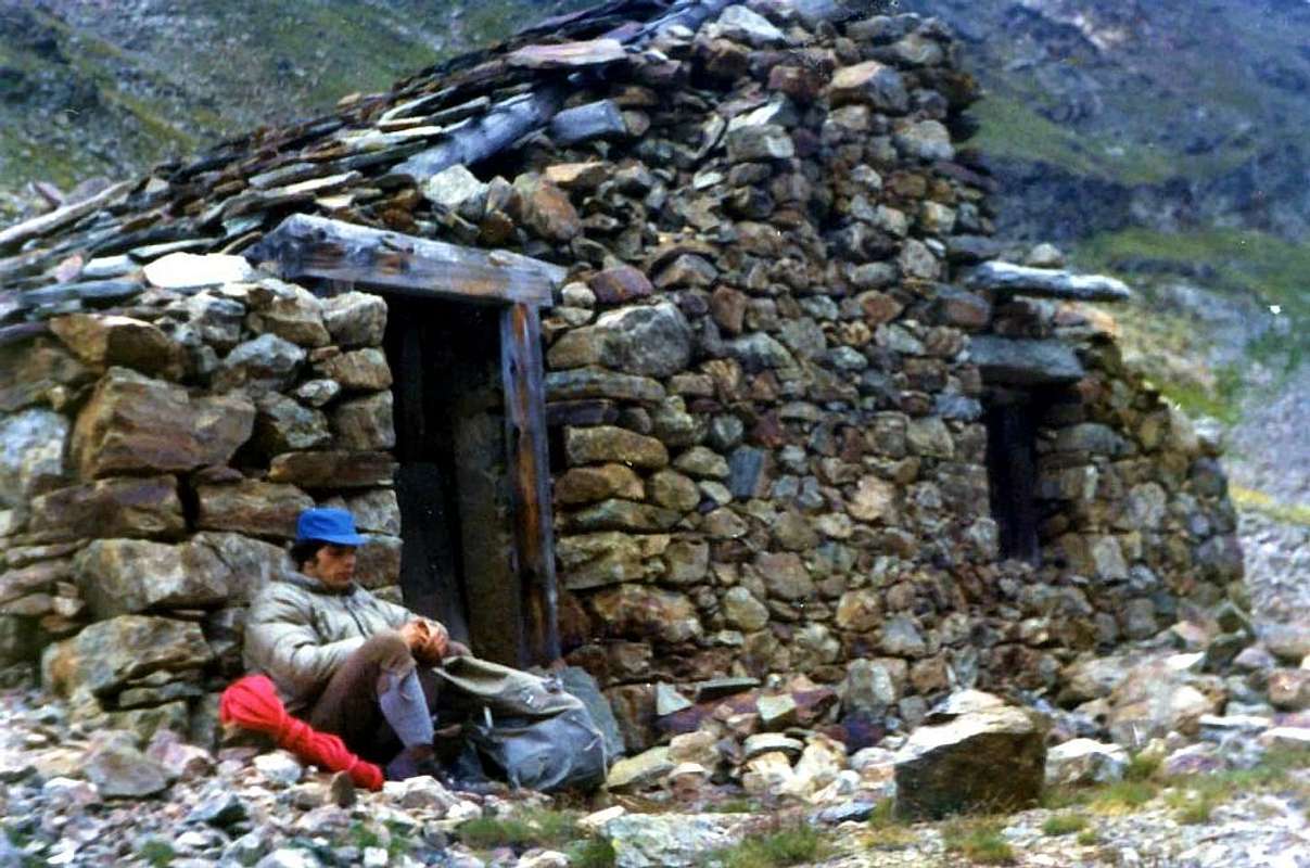
"Peckoz Shelter, here are parties, here have returned 1875", by Osw
"... a dangerous and exhausting work of 4 to 5 hours for those rocks all covered in ice and cut anywhere from walls impossible to overcome, difficult to turn around, took us to 100m from the top. Can not take more in high for the condition rocks escape to retreating ... ". Thus ends the "Dream" of the brave Martino Baretti and Luigi Bruno climb the first on the North Face of Emilius, ie the slope of Arpisson. Although there has been accompanied by two strong Guides of the Susa Valley as Augusto and Vittorio Sibille. But are the firsts from always to mature this idea. Mountaineers intrepid, valiant and courageous. Chapeau! Surely they've been to the old Shelter of Gamekeeper Baron Beck Peckoz Gressoney, owner of the broadest Hunting Reserve that the Valley of Saint Marcel, where in recent time is more limited, up to the Carrel Hill and expanded also to the nearby Punta Tersiva. From there are parties and there are back. With a bit of confusion in the head, to where they were going and for what they wanted to do. As in their tangled relationship appeared in the "Bulletin of the C.A.I. 1878", on page 565. It is not the others have much clearer ideas, so it is true that the celebrated Agostino Ferrari in his "Statistics 1908" sees this as the first ascent West Side, but this last did not have and still does not have the ice of which they tell. A mistake for him, yet thirty-three years have passed and is already another group of roped climbers have climbed on the wall in 1897. But let's calm ... When August 30th, 1897 came the resolute and with decisiveness Giovan Battista Devalle and Ercole Daniele, that the day before, starting from the huts Arpisson had made the first absolute ascent of Becca di Seneva (3.086m), also known as Becca du Cordagnì or the Shoemaker through the high and steep western Wall, the North Face of Emilius begins to "tremble". Together with the two in fact there are two expert Mountain Guides of the Matterhorn: Alexander and Luigi Bich. The small Emilius disappears in front of Her Majesty and feels that "virginity" of its North Wall is put at serious risk and danger. Extracts the nails, almost a claw, better a talon, and is fighting like a lion flaunting its ice shining the steep rock slabs and forcing them to "move" farther to the right, or to the West, as he had for the roped of 1875. So they are forced to do and this explains also the mystery of the confusion between North Wall and Wall West: both groups had started to climb the North but then had been "driven back" more to the West. Under the small Little Emilius. Gentlemen, here's the marching orders. If You like ...
"... un pericoloso e faticosissimo lavoro di 4 a 5 ore per quelle roccie tutte coperte di ghiaccio e tagliate ovunque da pareti impossibili da superarsi, difficili a girarsi, ci portò a 100 m dalla cima. Impossibile prendere più in alto per la condizione delle roccie battemmo in ritirata ...". Così termina il "Sogno" del bravo Martino Baretti e di Luigi Bruno di scalare per primi la Parete Nord dello Emilius, cioé dal versante dello Arpisson. Nonostante che si sian fatti accompagnare dalle due forti Guide della Valle di Susa Augusto e Vittorio Sibille. Ma sono i primi in assoluto a maturar st'idea. Alpinisti intrepidi e valorosi. Chapeau! Sicuramente han pernottato al vecchio Ricovero dei Guardiacaccia del Barone Beck Peckoz di Gressoney, tenutario di quella più larga Riserva di Caccia che dal Vallone di Saint Marcel, dove ora é limitata, arrivava al Colle Carrel e si espandeva anche verso la vicina Punta Tersiva. Da lì son partiti e lì son tornati. Con un pò di confusione in testa, per dov'andavano e cosa volevan far. Come nella lor ingarbugliata relazione apparsa sul "Bollettino del C.A.I. 1878", a pagina 565. Non é gli altri habbian idee molto più chiare, tant'é che il celebre Agostino Ferrari nelle sue "Statistiche 1908" la considera come prima ascensione per il Versante Ovest, che però non possedeva e non possiede tuttora i ghiacci dei quali loro raccontano. Un abbaglio anche per lui, eppure son passati trentatre anni ed un'altra cordata é già salita nel 1897. Ma andiam con calma ... Quando il 30 di Agosto del 1897 arrivano i decisi e più che risoluti Giovan Battista Devalle ed Ercole Daniele, che il giorno prima partendo dalle Baite dell'Arpisson avevano effettuato la prima ascensione assoluta della Becca di Seneva (3.086 m), conosciuta anche come Becca du Cordagnì ovvero del Calzolaio, tramite l'alta e ripida Parete Ovest, la Parete Nord dell'Emilius incomincia a "tremare". Insieme ai due infatti ci son due esperte Guide del Cervino: Alessandro e Luigi Bich. Il piccolo Emilius par scomparir di fronte a Sua Maestà e sente che la "verginità" della sua Parete Nord é messa a serio rischio e pericolo. Estrae le unghia, quasi un artiglio rapace, battendosi come leone ed ostentando i suoi ghiacci che lucidano i ripidi lastroni rocciosi obbligando costoro a "spostarsi" più in là a destra, ovvero ad Occidente, come aveva fatto per la cordata del 1875. Così son costretti a far ed ecco spiegato anche l' arcano di quella confusione tra Parete Nord e Parete Ovest: entrambi i gruppi eran partiti per scalar la Nord ma poi eran stati "ricacciati" più ad Ovest. Là sotto il Piccolo Emilius, che é altra cosa. Signori, eccoVi il benservito. Se v'aggrada ...
Mountain Conditions
Meteo: you can find all the needed informations at the official site of the Valle d'Aosta Region:
"Guida del Monte Emilius", di Osvaldo Cardellina Editore in collaborazione con il Club Alpino Italiano Sezione di Aosta, Dicembre 1978.
"Guida dei Monti d'Italia – Emilius Rosa dei Banchi Parco del Mont Avic" di Giulio Berutto e Lino Fornelli - Club Alpino Italiano/Touring Club Italiano, Marzo 2005.
"Guida delle Alpi Occidentali" di Giovanni Bobba e Luigi Vaccarone C.A.I. Sezione di Torino Volume II (parte II), 25 Maggio 1896.
"80 itinerari di Escursionismo Alpinismo e Sci Alpinismo in Valle d'Aosta", di Osvaldo Cardellina, Ed. Musumeci, Giugno 1977 (in Italian); seconda Ed. Luglio 1981; terza Ed. Luglio 1984; (in French), prima Ed. Febbraio 1978; seconda Ed. Marzo 1980.
"Diari Alpinistici" di Osvaldo Cardellina e Indice Generale accompagnato da Schedario Relazioni Ascensioni 1964-2019 (inediti).
Kompass "Gran Paradiso Valle d'Aosta Sentieri e Rifugi" Carta turistica 1:50.000.
L'Escursionista "Conca di Aosta-Pila-Monte Emilius" Carta dei sentieri (n° 4) 1:25.000.
Hapax "Les Sentiers Comunità Montana Monte Emilius", Luglio 2000 1:25.000.
Enrico Editore Ivrea-Aosta "Gruppo del Gran Paradiso" 1:50.000.
I.G.C. Istituto Geografico Centrale, Torino "Carta delle Passeggiate ed Escursioni in V.D.A. Conca di Pila-Gressan, 1:20.000.
External Links
More about Emilius Another description with 40 shots, 6 panoramas and a "handmade" map, about Emilius.
Pila web-site Pila, the famous winter station, has an active life even in summertime. In this link, you'll able to find time schedule for Chamolè Chair Lift.


 2320 Hits
 81.84% Score
 14 Votes