
|
|
Area/Range |
|---|---|
|
|
36.44117°S / 148.29346°E |
|
|
Hiking, Mountaineering, Trad Climbing, Sport Climbing, Toprope, Bouldering, Ice Climbing |
|
|
Spring, Summer, Fall, Winter |
|
|
7310 ft / 2228 m |
|
|
Overview- (not just Kossie)
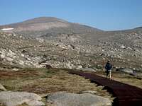
While most visitors to the area will be coming for Mt. Kosicuszko, it is worthwhile knowing a little about the range which Australia’s highest peak is a part of. There are many more enjoyable and less crowded peaks which lie in the nearby area which are much more appealing than Kossie itself. A visit to the area is hardly complete without at least a short detour off the elevated metal walkway which leads to the mountains summit.
The Main Range is really just an elevated plateau, whose peaks rise up little more than 300 metres above their surroundings. It is located in the Kosciuszko National Park and comprises the area above the tree line in the southern area of the park. In general most of the summits are quite gentle and do not draw those interested in mountaineering. However the granite boulders which scatter the slopes and the lack of trees creates a more impressive landscape than is usually found in the mountains of this part of Australia. Remnants of the Pleistocene glacial period are found in the presence of glacial lakes and cirques –the only on the Australian mainland. The area is renounded for it’s excellent bushwalking in summer, and ski touring in winter, the cliffs surrounding Blue Lake even offers one of Australia’s only ice climbing destinations.
Peaks
Kosciuszko 2228 metresThe highest mountain on the Australian mainland, sees a corresponding number of visitors. The summit is reached easily by an elevated metal walkway or a dirt road (closed to public) no technical skills are required, the return trip is 13km if you take the chairlift up from Thredbo.

Townsend 2209 metres
This peak, the second highest, is located approximately 4 kms north of Kosciuszko and despite it’s more impressive rock stacks which make up it’s summit and the better views from the top it sees only a fraction of the number of visitors that Kossie does. A narrow trail leads to the summit from the Main Range track just to the SW of Muellers peak

Twynam 2196 metres
The third highest mountain is similar to Kosciuszko in that it’s gentle sloping sides make it seem more like large hill than a serious mountain. But directly below the mountain on it’s southern side lies the spectacular Blue Lake. Relatively few people visit the summit, despite the fact that is easily reached from an abandoned road which leaves the Main Range track halfway between Carruthers Peak and Blue Lake.

Ramshead outcrops ranging from 2000 to 2150 metres
Often viewed but rarely visted, the Ramshead ridgeline is a series of rocky outcrops about 5km south of Kosciuszko. For anyone seeking some fun scrambling, bouldering or even skiing some tight couloirs in winter, this area is the perfect place for either a day visit from Thredbo, or for pitching the tent among the boulders and spending a few days.

Flora and Fauna
The vegetation varies from herbfields of snow grass and and snow daisies, heath, feldmark (consisting of bare, stony ground between plants), and alpine bogs. Common species include prickly snow grass, alpine wallaby grass, silver snow daisy, ribbony grass, white purslane, eye-brights, gentians and buttercups.
Animals in the area are somewhat lacking at first glance, with no large mammals inhabiting the area. A closer look reveals a variety of small reptiles, a few birds (pipits and ravens) and some small native marsupials like the endangered Mountain Pygmy Possum.
Watch where you walk and pitch a tent. The plants on the Main Range may look hardy, yet they are easily damaged by misplaced boots. Especially ridges which are home to some particularly fragile communities of windswept feldmark, (many of these plants are endemic to the area). Also the low lying boggy areas of sphagnum and sedge, which are also easily damaged, yet which play a vital role in filtering water. If you need to tread off the trail (and this should be kept to a minimum) try to tread on rocks or the alpine grass.
For more information check out the National Parks and Wildlife Service website Kosciuszko National Park
Camping
There are plenty of great camp spots, the big concern is finding a place which isn’t so fragile that you have a lasting impact on the environment.Do not camp in the catchment areas of the glacial lakes (Lake Cootapatamba, Blue lake, Albina lake, Club lake and Headley tarn) or resort areas of Thredbo and Perisher.
Do camp out of sight of roads and walking trails and atleast 100metres from water courses.
No fires are allowed- use a fuel stove.
In winter you might want to leave the tent at home and dig a snowcave instead.

The Huts
Huts such as Seaman’s and Cootapatamba are designated for emergency use only. In reality however they are quite commonly used by people on overnight trips. It might be unwise to rely on reaching a hut, as whiteouts occur (frequently in winter) and can make routefinding a difficult task, on long weekends in winter some huts might even be filled with other people. Bring and tent and/ or shovel to dig yourself a cave even if you intend to sleep in a hut.
Weather and Climate
The Main Range has a montane climate with a summer not much drier than it's winter and a mild to cold temperature all year round.Heavy precipitation which mainly takes the form of snow in winter months (from May through to October). This combines with low average temperatures to blanket the Main Range in snow for atleast a few months of the year. Above an altitude of 1400 metres (which all peaks on the Main Range are) snow covers the ground for typically 4-6 months.[img:252632:alignleft:small:][img:252633:alignleft:small:]
It should be noted that the weather is famous for changing quickly and without much warning, whiteouts can seemingly come out of nowhere, so it is always a good idea to carry a jacket regardless of the weather forecast.
Minimum average monthly temperature -7 to 0.4ºC
Maximum average monthly temperature 15.9 to 29.5ºC
Current conditions- BOM Website
Location and Getting There
The Main Range lies in SW New South Wales and forms the highest part of the Great Dividing Range a scattered collection of mountains running parallel with the coast of Australia\s east coast from Queensland down through NSW and finishing in Victoria. The closest ‘city’ is Canberra about 220km away, the closest town of a size big enough to have a camping store is Jindabyne 35 kms, and the village/ ski resort of Thredbo is nestled in the valley just beside the Main Range and has chairlifts which can take you up onto the plateau (for an exorbitant fee). Thredbo has a few amenities (ie. A small supermarket, some drinking holes, and plenty of accommodation- including a youth hostel) but is quite swanky and as a result an expensive place to visit. You are better off stocking up on supplies for a trip in Jindabyne.Thredbo and Charlottes Pass are the two places which offer the best access to the Main Range. To reach Thredbo from the west take the Alpine Way from Khankoban, from the east take the Kosciuszko Rd from Jindabyne. To reach Charlottes Pass take the road to Perisher Valley from Jindabyne and continue up past the ski resort, in winter the road is only cleared of snow as far as Perisher, oversnow transport is available to transport you the final distance up to Charlottes Pass. From June 1st to October 10th it is necessary to carry chains in your car, unless you have a 4WD.
If you drive to the park it is necessary to pay a park entry fee for your car, this is $16AUD and $27 between the June long weekend and the October long weekend (the ski season), there is a manned payment booth about 15km before Thredbo on the road from Jindabyne, the pass is valid for 24hours. If you arrive from Khankoban there is no pay booth as such but the NPWS office just off the road will sell you a pass if they are open, if not you can do so at the newsagent in Thredbo. Parking inspectors do walk around and check cars for the park entry stickers on a regular basis, so it is a good idea to make sure your car is covered.