
|
|
Mountain/Rock |
|---|---|
|
|
32.44480°N / 107.675°W |
|
|
Luna |
|
|
Hiking |
|
|
Spring, Summer, Fall, Winter |
|
|
5667 ft / 1727 m |
|
|
Overview
Massacre Peak is located northeast of Deming, NM and was a prominent landmark along the Butterfield Trail. Though the peak is relatively small elevation wise (5667') it does offer a nice little climb with some mandatory scrambling near the top to breach the cliff line that surrounds the summit plateau. The peak is named for the numerous deaths that occurred in this area during the operation of the Butterfield Trail. At one point there was a plaque on the summit that commemorated a memorial march done by 150 boy scouts, but during my visit I was not able to find it. The remains of a heliograph station are evident near the BM Massacre.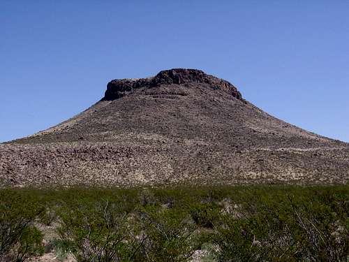
The breach in the cliff line can be seen just to the left of center
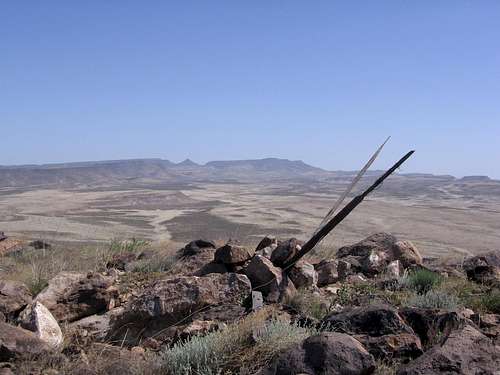
From the summit looking towards Magdalena Peak
Getting There
There are a number of criss-crossing dirt roads in the area that will get you close to Massacre Peak. The following is a route that should be accessible by sedan unless there have been some recent heavy rains.Leave I-10 @ exit 116, the first exit after the Border Patrol checkpoint (if heading west)
Stay on the north side of I-10 and keep headed west.
The road soon turns to the NW and becomes a dirt road, County Road C01. After 7.9 miles, you'll come to the entrance to a ranch.
Right before the entrance, turn NE on county road D01.
Go through a gate after 2.9 miles and keep going.
After another 2.6 miles, you'll reach a second gate
Massacre Peak will be looming ahead of you.
0.6 of a mile after the gate, you'll find the marked junction of roads D01 and D02.
Turn left or west on D02. Go about a mile and park.
Butterfield Trail
"Nothing Must Stop The Mail!"
The Butterfield Trail was a 2975 mile route that ran from St. Louis, Missouri, and Memphis, Tennessee, across northern Texas to San Francisco, California. In early 1857 John Butterfield was awarded a contract by the US Post Office for an overland mail route to to California which would not exceed a time of 25 days and would run two times a week. John Butterfield was awarded the $600,000 contract to complete this route and given a little over a year to get it into operation.
By September 1858 more than 200 way stations and relay posts had been setup and all of the necessary staff had been hired. In the same month the first overland mail run was completed and operations had begun on the Butterfield trail! Passenger fare was $200 from St Louis to San Francisco (Approximately $3000 in today's dollars). Eventually the trans continental railroad and the over bearing logistical costs of operating such an extensive system of stations and personnel forced the Butterfield Overland out of operations. In the end the Butterfield Stage route operated from September 15, 1858, until March 1, 1861 and served to captivate the imagination of the American public.
Cultural Significance
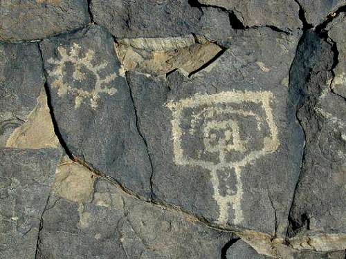
Ft. Cummings, located in the vicinity of Massacre Peak, played a primary role in the Indian Wars. In 1882, the mining town of Cookes was established along what is now the northeast boundary of the WSA. The Butterfield Trail, a major migration and communication route during the mid-1800's and now a gravel ranch road, forms the boundary between the Cookes Peak and Massacre Peak units. Massacre Peak is named for the many people that died along this section of the Butterfield Trail during this time period and Cookes Range is named after the Mormon Battalion commander who led troops through the area on the way to California during the war with Mexico.The cultural and historic component of Cookes Range is among the most significant in southwest New Mexico. A major petroglyph site in the southeast portion of the Cookes Peak unit contains Mogollon-style designs of crosses, abstracts, masks, lizards, plumed serpent, and birds. Another significant petroglyph site is found adjacent to Massacre Peak. The complex also includes at least one Lithic site and a four-room Classic Mimbres dwelling that may provide important information regarding Mimbres sites in an environmental zone where they usually do not occur
Pony Hills Petroglyphs
Bard - Oct 25, 2011 4:12 pm - Hasn't voted
Wrong DirectionsThere are two Massacre Peaks within approximately 20 miles east and west of one another. The directions provided (exit 116 off I-10) is not the Massacre Peak near Pony Hills. To get to the Massacre Peak that is off the Butterfield Trail, you need to exit A16 off highway 26 which runs between Deming and Hatch. Directions are correct for the other Massacre Peak.
willymca - Nov 22, 2015 8:14 am - Hasn't voted
Not NorthwestThis peak is Northeast of Deming, not Northwest of Deming. Otherwise Exit 116 would not make sense.
weeds19 - Nov 23, 2015 5:15 pm - Hasn't voted
Re: Not NorthwestThanks for the catch, I just updated the page.