
-
 23698 Hits
-
 89.01% Score
-
 28 Votes
|
|
Mountain/Rock |
|---|---|
|
|
50.33932°N / 127.28478°W |
|
|
Hiking, Mountaineering |
|
|
Spring, Summer, Fall, Winter |
|
|
4610 ft / 1405 m |
|
|
Introduction
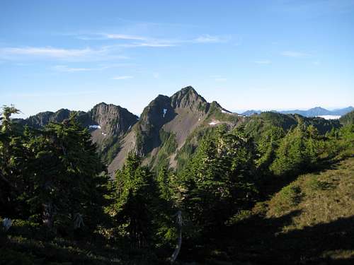 Merry Widow Mountain Merry Widow Mountain |
Situated between the Benson and Craft River watersheds to the east and west respectively and just 10 km as the crow flies from tidewater at the head of Quatsino Sound, Merry Widow offers the climber stunning ocean views and a unique perspective on its more formidable neighbours to the south and east as well as across the Strait of Georgia to the north coast mountains on the mainland.
To the north of the mountain the land drops rapidly to the lowlands north of the town of Port Alice. At these latitudes and at certain times of the year, marine cloud is a fact of life and since there’s not much in the way of an impediment, low-level morning fog frequently drifts up the adjacent river valleys until it meets the mountain barriers as far south as the Haihte Range. A morning ascent might often be in perfect, clear conditions above a bank of solid cloud. The endless views of range upon range of peaks peeping above a sea of cloud is a thrilling and moving sight.
As if this wasn’t largesse enough – and I never thought I’d write this about a north Island mountain – Merry Widow has superb access (with the right vehicle), requires negotiation of neither logging slash nor bush and even has a trail complete with trailhead sign. Sub-alpine forest leads to wonderful hiking along high, open alpine ridges and ends at a lovely exposed scramble to a small, airy summit.
Merry Widow is an absolute, incontrovertible gem of a mountain.

The inspiration for Merry Widow??
Frequent readers of my Vancouver Island contributions on SP may have noticed that I always like to include a little background history on the Island mountains that I write about. With a name like “Merry Widow” you’ve got to believe that there’s a fine story in there somewhere. Even before beginning my research, I had visions of the lonely but cheerful widow of a 19th century logger, living in a vine-covered cottage somewhere in the valleys below who would offer tea, sympathy and, perhaps, a little more to passing denizens of our early forest industry. Nah – I couldn’t find anything like that. In fact, I couldn’t find much, apart from the following.
Many Vancouver Island geographical names derive from the time of the extensive surveys of the 1930’s. At this time talking movies were relatively new and immensely popular. Cheesy musicals in romantic situations in particular appealed to a lot of people. In Canada what could be more appealing than the story of a Mountie and an opera singer in the Canadian Rockies. Step forward Nelson Eddy and Jeanette MacDonald in the high camp (not a climbing term in this instance) 1936 musical “Rose Marie” and the never-to-be-forgotten (no matter how hard you try) song lyric “I’ll be calling yooo…oooo…oooo….oooo;oooo….oooo….oooo”. Camp or not, dreadful or not, Rose Marie and Jeanette MacDonald were household names in Canada and elsewhere in the years before and during the Second World War. Prior to Rose Marie, Jeanette had done a lot of work with Ernst Lubitsch, a prolific director of scores of standard-issue but stylish costume dramas and musicals. Amongst Lubitsch’s extensive repertoire, and starring Jeanette herself, was the 1934 musical, “The Merry Widow”.
Let us conclude therefore, that one or more members of the 1934-1938 survey team loved Rose Marie, wanted more of Jeanette, sought out the earlier Merry Widow and loved it even more. Enough, in fact, to recommend the naming of a river and mountain after it. Far-fetched? Perhaps. But that’s my version and I’m sticking to it. Certainly, I like it better than naming the mountain after Franz Lehar's soppy Viennese operetta of the same name.
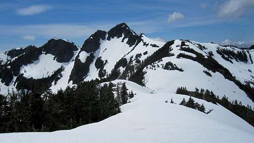
Approaching Merry Widow in early season
Getting There
Vancouver Island can be reached by air from Toronto, Vancouver, Seattle, Calgary and Edmonton to Victoria, Nanaimo, Comox or Campbell River and by ferry from Port Angeles to Victoria on The Coho and on BC Ferries from Vancouver to Victoria or Nanaimo. Public transport on the Island is notoriously poor and anyone arriving by air would be advised to rent a car.Access in this case involves steep, rough, de-built industrial roads with deep water bars. A 4WD vehicle with high clearance is essential in order to proceed beyond the main lines in the valley bottoms and reach the very top of the road that gives access to the mountain. Chains may also be required if the roads are still under snow. This can occur well into May.
From any point on southern Vancouver Island, drive north on the Island Highway 19 to Campbell River and beyond towards Port Hardy, the last community of any significant size in the north Island.
Proceed through Sayward Junction, the village of Woss and the turn-off for Port McNeill. Exactly 3.7 km past the latter turn left on West Main logging road. The road becomes gravel immediately.
Approach
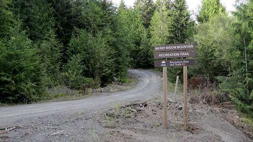
Proceed 3.5 km on West Main to a prominent junction with Keogh Main Road after 3.5 km. Keep left on Keogh.From the West/Keogh junction, drive 28 km up the Three Lakes valley to the junction with Raging Main and turn right. Proceed a further 2.5 km, cross the bridge over the Benson River and turn right again on to Alice Main – confusingly also called Merry Widow Main on some maps. Drive 1.2 km on Alice Main and locate the signed Merry Trail Main/M1080 spur on the left. If you haven’t done so already, lock in 4WD here. You're not going far without it and your vehicle should also have high clearance.
Western Forest Products are responsible for the road and have recently followed legislative requirements to partially deactivate it. This means 33 cross ditches and water bars to negotiate, the first of which is just a few metres uphill from the trail sign. The good news is that a large washout at N50° 21.248 W127° 15.589 has been repaired and that you can now drive all the way to the trailhead. The steep section immediately below the mine is also in better shape and the brushy section above the mine has been widened and cleared out. With all this is mind, proceed from the main line as follows.
At 1.2 km from Alice Main, and N50° 21.072 W127° 14.372, the main road appears to bend sharply right. However, Merry Trail goes straight on – or, perhaps more accurately, bears slightly left.
At 2.6 km from Alice Main the road leaves the course it has been following up Merry Widow Creek and bends sharp right.
 Merry Trail Access Road | 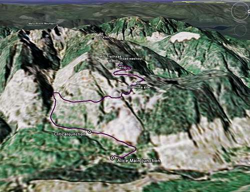 Merry Widow Approach Roads | 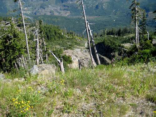 Old Minesite | 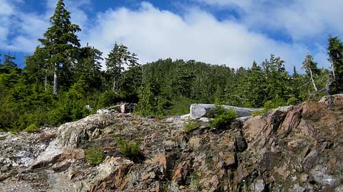 Merry Widow Trailhead 2016 | 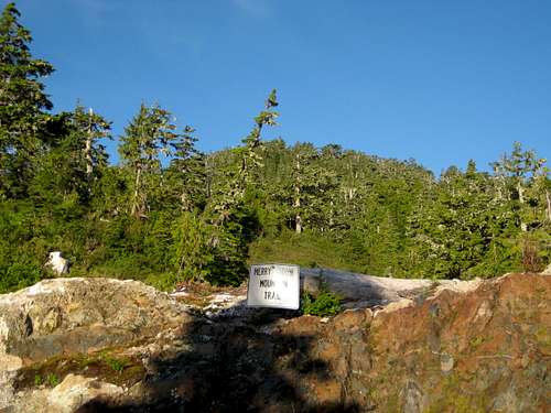 Merry Widow Trailhead pre 2012 |
Spurs lead off from the old mine to left and right (that to the left to an overlook over a large open pit mine). Keep straight on up the hill a further ~1.8 km from the flat area to N50° 21.185 W127° 15.549 and find the Merry Widow Mountain trailhead above the rhs of the road. There is adequate space to park here. Altitude at this point is approximately 1,040 metres.
At N50° 21.299 W127° 15.539 just before the last left hand bend, there is a pullout to both camp and park. This spot has superb views right down the Benson River valley to the Haihte Range and beyond.
As well as the waypoints noted above, refer to the GoogleEarth image above. Any reader wanting a MapSource GPS tracklog of the approach has only to email or send me a PM.
As well as the waypoints noted above, refer to the GoogleEarth image above. Any reader wanting a MapSource GPS tracklog of the approach has only to email or send me a PM.
Summit Route
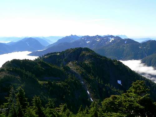
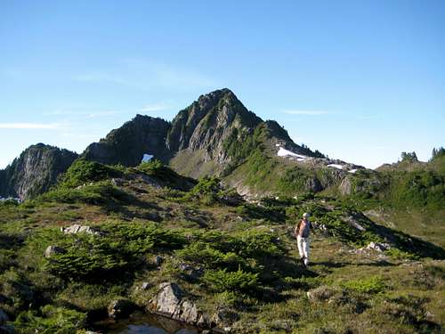
Leave the old road on the well-marked trail and proceed up through lovely open sub-alpine meadows and forest in a generally southwesterly direction. The path is well booted in and also marked with yellow and red disks mounted on trees in clear view. There is no bush whatsoever to deal with.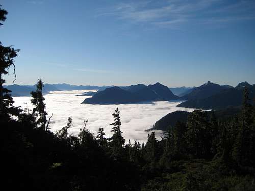 View S from the Merry Widow Trail | 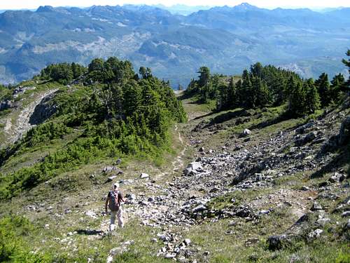 Merry Widow Trail | 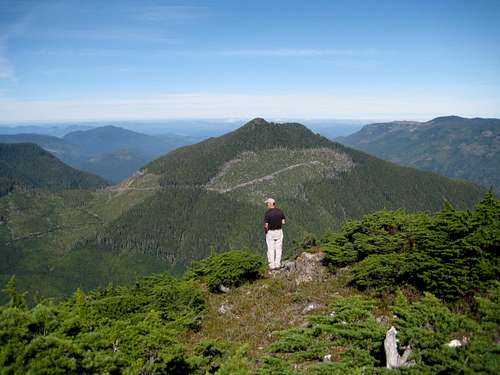 Peak 4349 | 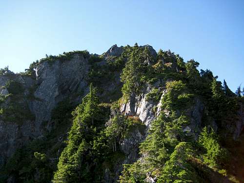 Merry Widow North Ridge | 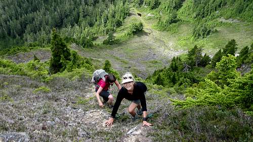 Climbing Merry Widow Summit Block. |
The terrain in now open and completely in the alpine. Go up along the lovely broad ridge and arrive on the cairned summit of Peak 4349 about an hour from the start. Merry Widow is now in full view 1.5 km to the south.
Leave the summit of 4349 and go down 100 vertical metres to a wide saddle. Cross this and go back up to the top of another bump on the ridge. Descend once more and back up to the base of the north ridge of Merry Widow.
Climb the 70 vertical metres of steep and exposed ridge with some Class 3 in about 10-15 minutes from the base. Stay on the right of the crest at first before traversing back to the ridgeline just over halfway up.
The summit is quite small, very airy and has a cairn but no register.
 Merry Widow Summit View S | 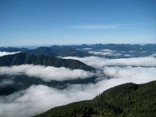 Merry Widow Summit View W | 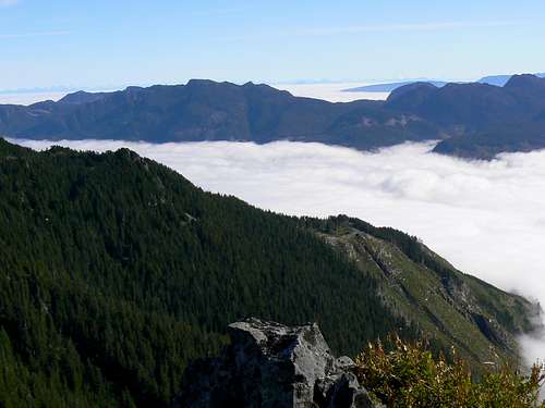 Merry Widow Summit View NE | 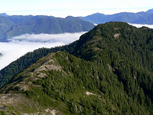 Merry Widow Summit View N |
To the north are the last hills of the north Island and the flat northern lowlands beyond. To the south, peaks beyond number, some familiar, many not. To the west, lower but rarely (if ever) climbed unnamed peaks, the convoluted inlets of the west coast and the open Pacific. To the east, one last low range only stands in the way of an unobstructed view of the mainland north Coast Mountains. Northeast and nearly 200 km away, Mt Waddington’s massive bulk can be clearly seen towering above its neighbours.
Descend by retracing the upward route.
The round trip distance is just over 8 km. In spite of the modest elevation difference between the top of the approach road and Merry Widow, the requirement to traverse Peak 4349, as well as several minor bumps, means that you’ll climb some 900 metres of relief to summit the mountain and return to your vehicle. Allow 5-6 hours, which includes at least an hour on the summit for all the photos you’ll want to take.
A MapSource GPS tracklog of the route is available for the asking. Just send me an email or a PM.
 Approaching Merry Widow N ridge Approaching Merry Widow N ridge | 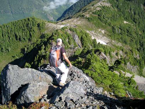 Heading down off the summit Heading down off the summit |
Red tape
Absolutely none.An intentions system simply doesn’t exist in this neck of the woods. Make sure, therefore, that you have left a detailed trip plan with someone responsible. The RCMP and the appropriate SAR agency will respond in an emergency but it is up to you to have the mechanism in place that will initiate the call-out process if it becomes necessary.
Camping
As described in the approach section above, at the top of the approach spur road in the comfort of your vehicle or anywhere you care to pitch your tent. Fires are nominally prohibited and you should pack a stove. However, this is at your discretion. There’s not going to be anyone around to enforce any rules.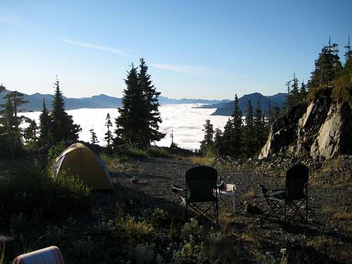 Camp near the Top of the Approach Road |
Weather
Nearest point current conditions and forecast.Northeast
Northwest
Additional Information
The correct map for this trip is the government 1:50 000 topographical map sheet 92L/, “Port Hardy”. Advance copies can be ordered on-line at this link. Copies are usually readily available in good bookstores and outdoor stores throughout the Island.Suggested Reading
Island Alpine – A Guide to The Mountains of Strathcona Park and Vancouver Island, Philip Stone, Wild Isle Publications, 2003, ISBN 0-9680766-5-3 and/or visit Island Alpine Climbing GuideBy all means read what IA has to say but be alert to missing or erroneous information. The guide describes the Keogh/West junction as being 4.5 km from the Island Highway, when, in fact, it is 3.5 km. Much more importantly, once on Merry Trail Main, IA asks the reader to “turn right after 2 km and follow this branch road as high as current road conditions allow…”. There is no such right turn or branch road. The only right turn possible is at the road junction after 1.2 km and leads to nowhere other than some very interesting mine workings. Merry Trail Road leads directly to the trailhead as described in the approach section above. Use all the information at your disposal not just one source.
An excellent guide to the back roads of Vancouver Island is Backroad Mapbook. Volume III: Vancouver Island
Summit Panorama
  |