INTRODUCTION
The summer of 2012 was an excellent intro into State Highpointing. We had success on our travels through the southern Appalachians and then New England. They were both a beautiful contrast, and provided lots of fun memories. After the summer, i continued my research on the logistics of the rest of the state HP's around the country. It seemed as though there was some breath to this mission. So, after figuring out my work and personal schedules, I decided that i wanted to make a go at completing the lower 48 state Highpoints between the next two summers (2013/14). Yes, this is still a lofty goal, one that has only been completed by less than 500 people in the USA. But i figured while i am still relatively young and in good shape, this is the time in my life to try it out. In order to accomplish this, it would require several trips this summer(2013), to be in a position to finish next summer(2014).
The same buddy, Travis, that traveled with me last summer, happened to be on business in the Baltimore area around Memorial Day weekend. The lights were going off in our heads that we just had several states left on the east coast, all of which were centered around the Mid Atlantic. It would be nice to knock out the east coast entirely, before our planned trip to the plains and lower Rockies next month. Soooo, I made my way up to Baltimore on Memorial Day weekend. This time, we were going to make a loop around 5 states and the District of Columbia. We were going to hit DC's high point first, and then WV, MD, PA, NJ, and finally DE. 5 states, a road trip that spanned over 900 miles in basically 3 days. Seems long, but when you look at a map of the nation's high points, this is the logical grouping for a trip. Also, the reason for stopping in Washington DC was simply that we were driving through the area, and figured that it could be a state one day. I won't include a full section on DC, other than we just had to drive around city streets to find it, and snap a few pics. Here is a pic below of Fort Reno, the official Highpoint of Washington DC.
![Fort Reno, DC]() Fort Reno, HP of Wash DC
Fort Reno, HP of Wash DC
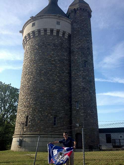
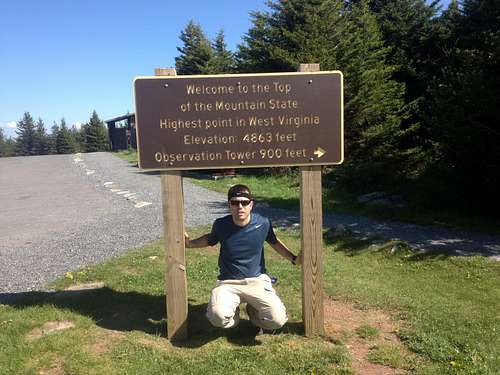
Spruce Knob, West Virginia - State HP #16
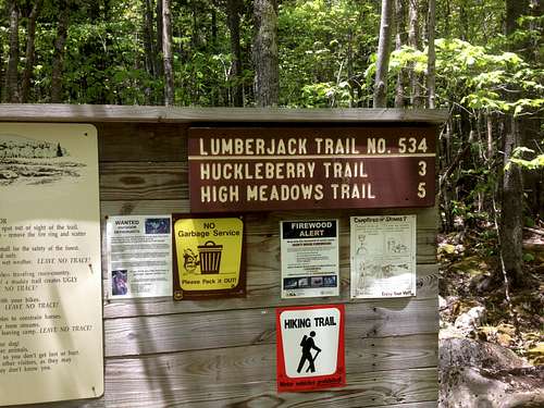
After leaving early on Friday morning from the Baltimore area, we hit the DC high point quickly, and then headed out of town. From Wash DC, it was a four hour drive west through Virginia and into the mountains of West Virginia. It was a very scenic drive out there, and we had a stellar weather day. We followed I66 west, and once we crossed over I81, we followed state roads towards the Seneca Rocks/Spruce Knob NRA. Spruce Knob had a couple options to get to the summit. We decided that we wanted to get as much early season hiking in, rather than just drive the road up to the summit. So, we took the 8 mile Lumberjack trail which turned into the Huckleberry trail.
![Lumberjack trail head]() Lumberjack trail head
Lumberjack trail headIt was well marked in finding the start of the Lumberjack trail, and there was parking for a few cars there. On this day, there was nobody parked at the trail head, and we only saw 3 or 4 people hiking the trail at all. Fine for us, as the weather was great, on a late spring day. The first 3 miles were totally flat, and actually somewhat muddy. There were spots where we had to jump across the mud bogs, so our feet didn't sink. It was 3 miles until the junction with the Huckleberry trail, which was also marked very well. Once we turned onto the Huckleberry trail, it was still relatively flat for most of the way. We had some portions of incline, but nothing too tiring.
![Huckleberry Trail, Spruce Knob]() Along the Huckleberry Trail
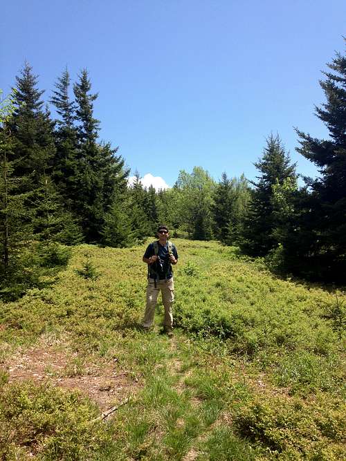
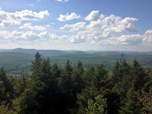
Along the Huckleberry TrailMost of the way we crossed through forest, and the smells of the woods were great! It was just nice to be back out on the trail. Towards the upper portions of the trail, we would have views every now and again. We noticed that we were actually gaining some altitude and could the the Allegheny's around us. The trail as a whole was very easy and well marked. It was long, but a great way to welcome the coming summertime. We made our way to the summit area in great time, probably 3 hours. Once there, we had to cross the road and parking area and make our way to the tower overlooking all of West Virginia.
The tower was made of stone. It had a couple floors of stairs and opened up to 360 panorama views of the Allegheny's. WOW!
![Allegheny views, Spruce Knob]() Allegheny views, WV
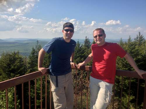
Allegheny views, WV![Spruce Knob summit]() Spruce Knob summit
Spruce Knob summitAs is customary with all the high points, we had to find the USGS survey marker, which was on the ground behind the summit tower. After finding it, we took our pics. At this point, it was afternoon and we were not really interested in the long, relatively flat hike back to the trail head. We still had to find our accommodations for the night which were 30 min away. So, we asked a couple that happened to be up on the tower to drive us back down and drop us off at the car. They were very nice in doing so, and we wished them well on their travels too.
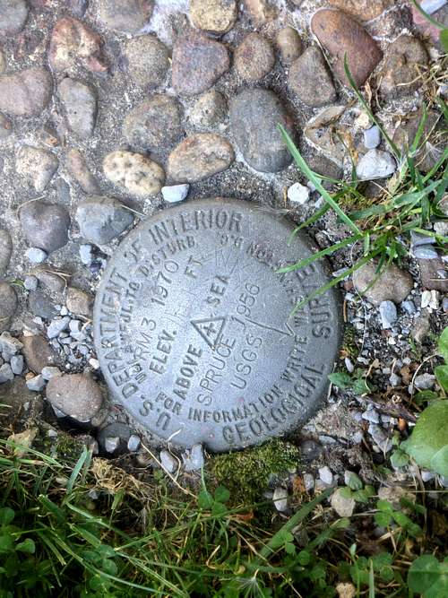
![Spruce Knob survey marker]() Survey marker Spruce Knob
Survey marker Spruce KnobOnce back at the car, we traveled further north up the valley. We stayed at the Canaan Valley Resort that night, which we had heard about from some other travelers. The resort was, situated in the Canaan Valley, was surrounded by the mountains on all sides. We were just there for the night, but wished it were longer. It had all types of activities from a golf course, to ski lifts. The main lodge had a comfy dining room serving food with views through large floor to ceiling windows, overlooking the horizon. It was a relaxing way to end our long travel day. Next morning we had two more state high points on the agenda, (Maryland and Pennsylvania), so we had to call it an early night!
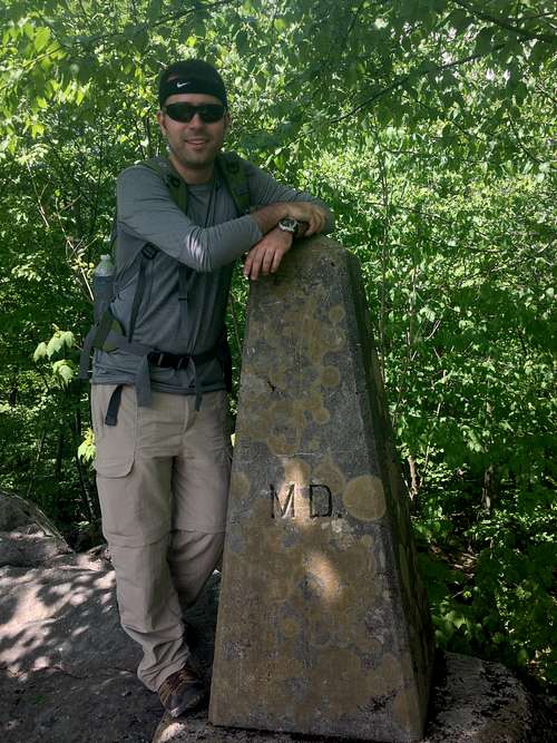
Backbone Mountain, Maryland - State HP #17
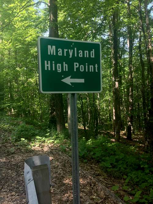
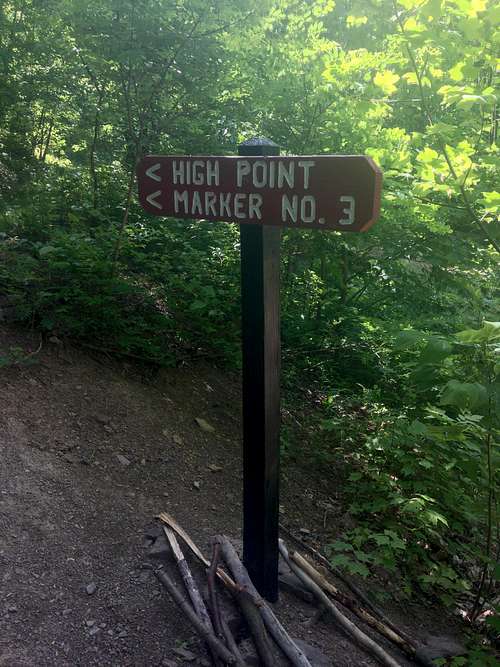
The drive up to Backbone Mountain was less than an hour away. This was the shortest leg of the trip, and easy to follow. From 219 on the West Virginia side, there were 2 green Maryland High Point signs as advertised. We parked alongside the road in an area that was large enough for a few cars. We just had to walk up the road a few paces and enter the trail. It was an old logging road, well worn and despite other reports on here, EASY to follow. There was signage immediately after hitting the trail that looked like this;
![MD High Point sign]() Sign once we hit the trail
Sign once we hit the trailThe trail was only about 1 mile long, with a gain of 700 ft. There were other signs along the way that looked this;
![MD sign along the trail]() Sign further along the trail
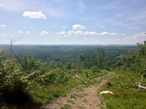
Sign further along the trail. There was also a veer off just before the summit, which passed by a cool monument that i'll explain shortly. Once at the summit, called Hoye Crest
![Views near Backbone's summit]() Views near Backbone's summit
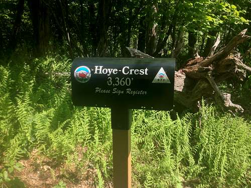
Views near Backbone's summitThe trail eventually opened up to some nice views near the summit area, called Hoye Crest. Just before reaching Hoye Crest, the trail had veered off and passed another stone monument, but ill get to that shortly. At the summit, we noticed the mailbox, which was provided by the High Pointers club. So, of course we signed the summit register and sat at the picnic table.
![MD summit mailbox]() MD summit mailbox
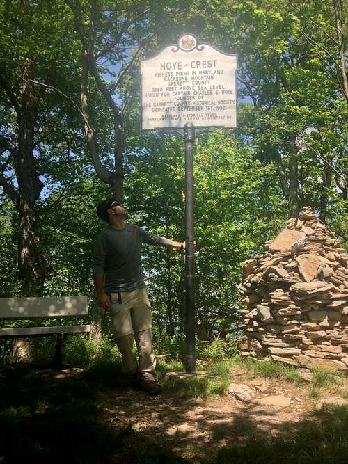
MD summit mailboxHoye Crest was very relaxing. The weather was around 75 degrees, with a nice breeze coming through. There was a huge cairn and the famous sign, with views out beyond the trees.
![Hoye Crest sign]() Hoye Crest sign
Hoye Crest sign![Views from Hoye Crest]() Views from Hoye Crest
Views from Hoye CrestAfter hanging around the summit for about 45 minutes, we decided to head back. As i mentioned before, just below the summit was a veer in the trail. We were curious as to what was in that direction as we knew it met up with the trail back under the canopy. We ventured that way, and after climbing over some rocks, noticed the MD/WV state line monument. It was large and made of stone, what a surprise!
![MD/WV state line monument]() MD/WV state line monument
MD/WV state line monumentOnce back to the trail head, we hopped in the car and headed up toward Pennsylvania for our second state High Point of the day!
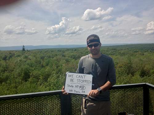
Mt Davis, Pennsylvania - State HP #18
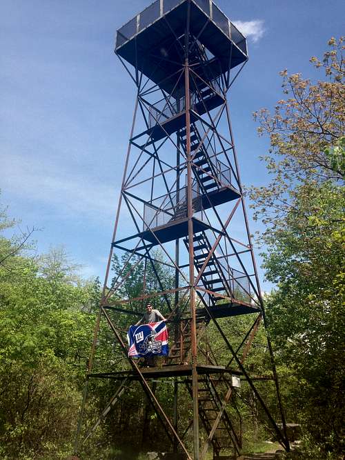
Mt Davis, Pennsylvania's high point, wasn't too far from Backbone. It took us just over an hour to find the road into the high, flat plateau they call Mt Davis. The roads in that area can be slightly confusing, but not too bad. While driving this route, we passed by Amish communities. It was interesting to see people in horse and carriage on the side of the road. It was hilly in this part of PA, but the mountains weren't towering over us like previous states. Again, Mt Davis didn't really feel like a huge peak, but more of an elevated plateau. We drove up to the picnic area and hiked on the trail through the woods and over to the observation tower. It must have been less than a mile.
![Mt Davis observation tower]() Mt Davis observation tower
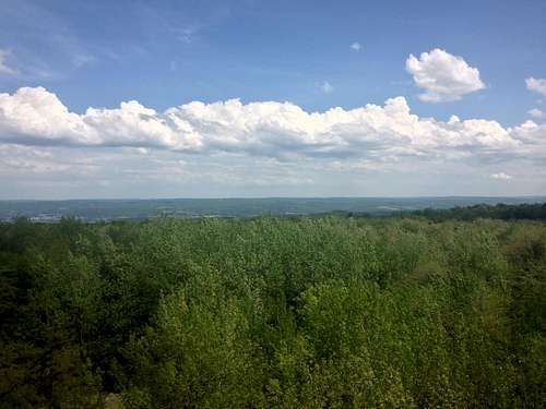
Mt Davis observation towerThe trail was just a short stroll through the woods on a very nice day. After about 3/4 of a mile, we saw the observation tower. Obviously, we climbed up to the top, so we could a panorama of the state of PA! The views from the top were great. We could see back into MD on one side. We could also see huge wind turbines in the distance.
![Mt Davis Summit]() Mt Davis summit views
Mt Davis summit viewsWe hung out on the tower for 30 minutes or so, and then said our goodbyes. After this peak, we had a considerable drive up into northern PA, to be ready for the next day and two more highpoints.
![Mt Davis]() Mt Davis
Mt Davis We made it up to Wilkes-Barre for the night. The plan for Sunday was to drive over to northern New Jersey to hit High Point St Park, and then all the way south, stopping near Wilmington to visit DE's highpoint, on the way back to Baltimore.
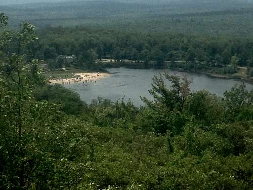
High Point, New Jersey - State HP #19
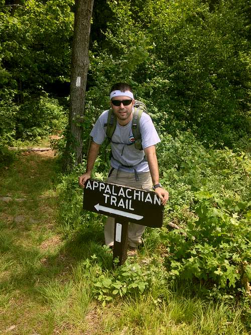
We woke up early and made the 1.5 hour drive along I84 toward the tri state border of NJ/PA/NY. High Point is the appropriate name of the highpoint of New Jersey. The state park sits in extreme northwestern NJ, near that tri state border. Most people just drive into the park, and walk from the parking lot right up to the monument at the summit area. However, the Appalachian trail happens to cross through, and we picked it up from just outside the park, near the headquarters. Again, if there's a way to hike to any of the state summits, we try to instead of just parking right at the summit. Plus, it was a scenic hike, and yet another state where we could say we hiked on a small part of the A.T.
l
![Appalachian trail NJ]() Appalachian trail NJ
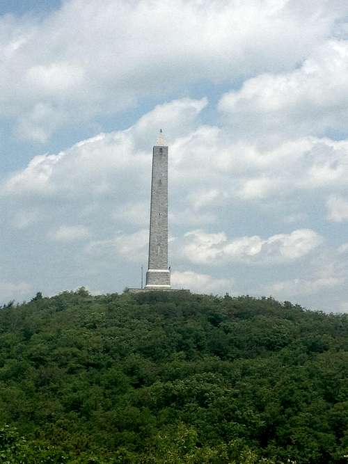
Appalachian trail NJThe trail was less than 2 miles to the summit monument. It started just south of the park headquarters, on the west side of the road. It was the fifth state high point whose route inquired at least part of the Appalachian trail. The trail entered the nearby woods and went on for about one mile before we found a nice viewing deck. There was no real elevation gain on this first section. From the platform, the monstrous monument at the summit was visible and the direction towards the summit was apparent.
![High Point monument]() High Point monument
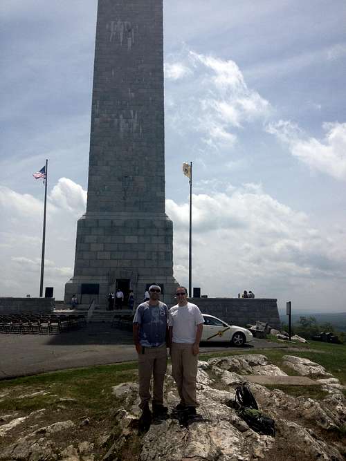
High Point monumentWe dipped back into the trees and followed it until the junction with the monument trail. I would say that the junction was no more than a half mile past the viewing platform. This trail wound near the road up towards the great monument, with some elevation gain. It was slightly steep just below the summit. Once at the summit, we walked all around monument for some nice views.
![Summit pose, NJ]() Summit pose
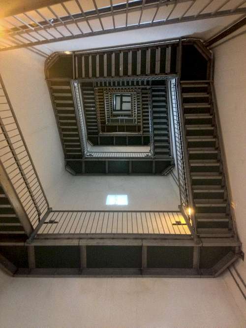
Summit poseThen, we decided to climb the spiral staircase to the top of the tower for the best views in the whole state of New Jersey. Once we got there, it smelled very musty, and it was hard to breathe in the air choked room. But we quickly snapped a couple pics and then headed back down.
![NJ monument staircase]() Never ending staircase
Never ending staircase![Top of the tower views]() Top of the tower
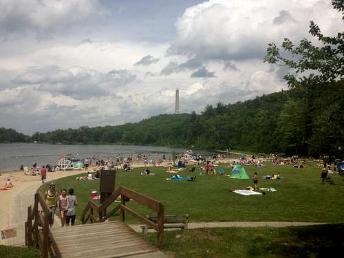
Top of the towerWe retraced our steps from the summit hill, but then diverted onto the road and hiked back down towards the beach pictured above. There were many people swimming and hanging out by the shores of this lake. Why not, it was a beautiful late spring day in New Jersey, and this was the nicest part of the state i've seen. Yes, New Jersey can actually be scenic, wow! After freshening up, we followed the road back out through the park gates and across the street to the hikers parking lot. This was a very nice afternoon, but the day wasn't over yet. We still had to hit the road, as we were heading southbound to find Delaware's highest point too!
![Beach side, High Point, NJ]() Beach day at High Point
Beach day at High Point
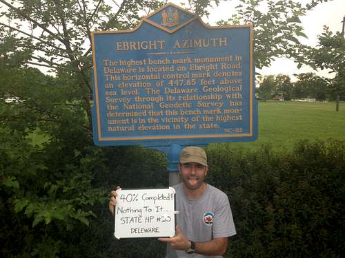
Ebright Azimuth, Delaware - State HP #20
This was the easiest of all of our state highpointing navigation. We had to continue south through New Jersey and find our way to I95. Once through the Philly area, it required us to veer off the highway into Delaware. Ebright is in a neighborhood just to the north of Wilmington, DE. After finally making our way through the surrounding streets, we finally found the correct road where the sign and usgs marker sits. The Ebright sign is in front of a park on the intersection of Ramblewood Dr. and Ebright Rd. It literally sits in the middle of a regular suburban neighborhood. What a stark contrast from some of the larger peaks we had climbed to date. Oh well, each highpoint is uniquely different! So, as cars were passing and probably looking at us strangely as we celebrated our last "summit" of the trip, we took all of our requisite pics. It was yet another happy moment, as I reached my 20th state highpoint!
![Ebright Azimuth]() Yey!! 5th successful highpoint of trip!
Yey!! 5th successful highpoint of trip!This long weekend went off without a hitch. We zoomed through the five state highpoints that were left to complete the east coast. It was amazing to me to see how far we had come already. At this point, i am systems go on continuing with the epic mission of nationwide conquest, lol! We have plans next to finally head west, and get our first taste of some serious altitude. Around July 4th, we are going to fly to Denver, and visit several plains states including Nebraska, Kansas and Oklahoma. Then we will finally catch some elevation, and hike the higher peaks of Guadalupe, TX, Wheeler Peak, NM & Mt Elbert, CO. Phewwww, until then, it's time to train and be ready for some of the nations tallest mountains. I CANNOT WAIT!! See ya on the next trip report............
Comments
No comments posted yet.