
-
 1947 Hits
-
 79.78% Score
-
 11 Votes
|
|
Canyon |
|---|---|
|
|
45.67717°N / 7.22257°E |
|
|
Hiking, Scrambling, Canyoneering |
|
|
Summer, Fall |
|
|
Overview

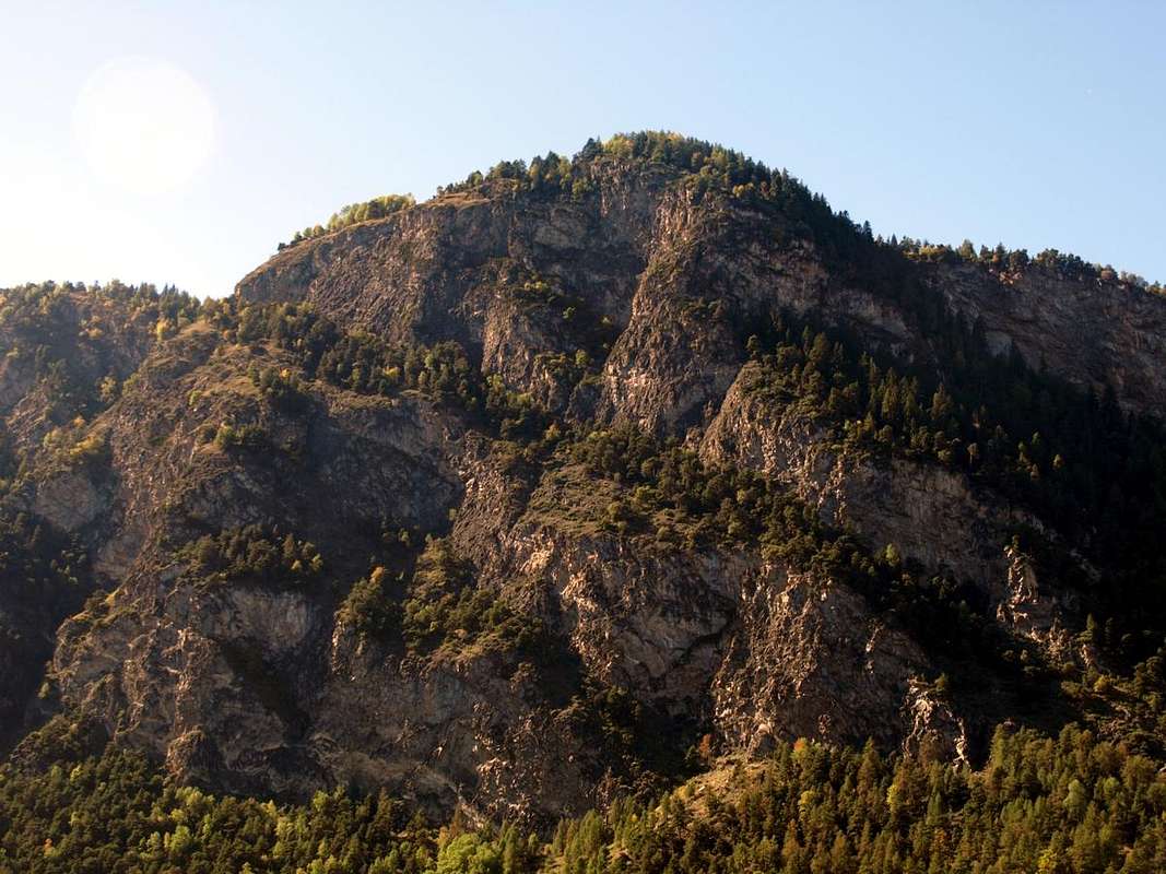
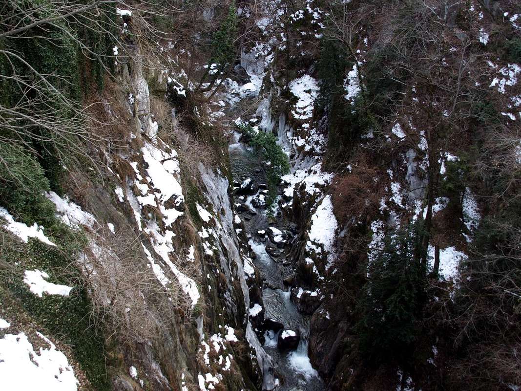
We have already spoken of Pondel or, more ancient times, Pont d'Ael, a small fraction of the Municipality of Aymavilles (646 meters and 7.4 kilometers West of the City of Aosta); as small and unknown as ancient. Certainly already inhabited by the People of the Salassi before the arrival of the Romans who, founded the City of Aosta or, better, Augusta Praetoria Salassorum, in 25 BC, after gradually began to appropriate also the surroundings. That was a story that concerned exclusively the construction of the ancient bridge over the Grand Eyvia river that descends along the entire Valle di Cogne (see the article of January 6, 2016: "Archeo / d True History of Channel Pont d'Ael (Pondel ) to Châtel Argent between Aymus et Avilius (Aymavilles) & Villeneuve "); this one instead wants to talk to you and describe the wild gorge with its ravine that precedes the inhabited area of Pondel (893 m), encased in a ravine on the slopes of Mont Poignon or Mont de Poignon (1567m). This turns out to be the first mountain above the Municipality of Villeneuve (670 meters and 10 kilometers West of Aosta) of that long watershed that from the bottom of the valley reaches first the two splendid pyramids of the Grand Nomenon or, in ancient times for the locals the "Gran Punta", ( 3488m) and La Grivola (3969m); as well as, at its Southern end, the Gran Paradiso (4061m), dividing the Cogne Valley and separating it from the adjacent West of Valsavaranche (better than French Valsavarenche, since the main stream was called and is called Savara and not Savare). The Grand Eyvia Torrent that from Cogne descends towards the Northwest, at first with a "peaceful path", turns, along the way and past the hamlets of Crétaz 1494m) and Epinel (1432m) , into an increasingly steep and impetuous stream, such as to force the Regional Road to cling to the high through the Southern forests at the foot of the wild Punta del Trayo or Tradzo and also Trajo or Traso (3127m) and the following, after the very small Villages of Senayet (1287 meters, North of the river), Sylvenoire (1331 meters, in South) and Charossaz (1183 meters, North of it again), Grand Nomenon Valley. This originates from the last hamlet of Aymavilles or Vieyes Village (1132/58m), located on the border with the Municipality of Cogne.
![]()
Mont de Poignon (1567m) Eastern Side highest sector over Grand'Eyvia Torrent
by Osw October 2016
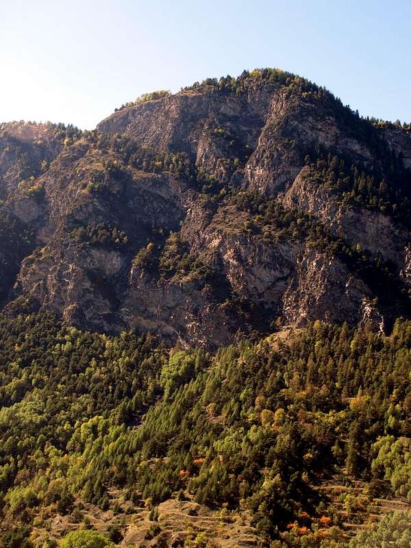
From this point the Grand Eyvia River, "colliding" with the terminal rocks of the small Becca Plana (2296m) and also pushed, after that of Grand Nomenon near and to the East from the Village of Vieyes (1158 meters, beautiful Sant'Andreas 's Church at the entrance into the hamlet) , by the two Southern Torrents de Beligny and Grand Creton, first becomes "grumpy" starting to flex its head towards the Northwest and then, entering in conflict with the hard rocks of the Grand Poignon (1571m), "irritated" bends sharply to the North, leaving behind the Pont de Chevril (961m) and the homonymous village (967 m). Beyond, discarded downstairs the overlying Village of Sérignan (1193 meters, small Church of Santa Anna) now in the Ozein 's Basin (at Pila-Resort adjacent to the East), through a double and harsh change of direction, he goes "angry" towards the Hamlet of Pondel or Pont d'Ael (893m) and his Roman bridge of 3 BC or, if you like, of the year 750 in Rome, or rather "ab urbe condita" ... The history of Pont d'Ael, Frenchized in local patois as Pondel, tells us of this great relic, also used here to testify the greatness of ancient Rome, suspended more than fifty meters above the river bed; a double covering, or rather a double passage with one covered and the other uncovered, characterizes it. The first was used to run irrigation water and more (see at this regard the article cited), while the other was used for the transit of people and livestock in a width of 1.08 meters, which becomes 2.26 meters including side walls. The difference in height between the two passages is 4, 12 meters, while the length of the same is equal to the overall height on the Grand Eyvia (about 50/2 meters). Reached, with a descent from the Regional Road to Cogne, by car the Village of Pondel (small parking lot immediately near the little Church of Sant'Andrea), with a short descent to the Southwest you reach the bridge, from which you can admire the Orrido di Pondel (Pondel 's Ravine), the waters of which wide by cutting and wounding the rock. A rock that protrudes downwards with a domineering scream, almost capable of denouncing the wounds suffered over the millennia. To say that it is possible to travel this narrow canyon is a risky thing, while we can affirm how it can be admired, as well as from the bridge, on the Eastern side, partially, from the Regional Road; while on the opposite one runs a bold path, the n ° 2, that sinuously and in parallel goes up from the two farms of Issogne ((851meters and "expanses" on the lower edge of the meadows in an area certainly less steep) up to Pondel, whence another numbered 3 goes back to the Southwest the steep grassy-rocky slopes that reach the Small house of the PNGP (1559m) nearby the tiny Alpine pasture of the Petit Poignon (1540m). On the same path, reached the altitude of 1130 meters, a detour heads South-southeast, reaching the Alp of Charpinel (1186m) located just above the Chevril Bridge with an unnumbered little path; from here can admires the entire rocky gorge. Continuing instead with the same, but more towards the West-Southwest, you get to that of the Grand Poignon (1571m), a place to which also a road arrives first in asphalt and then farm dirt road that from the crossroads 680 meters after the former Furnace goes up the hill immediately behind it passing through the hamlets of Martignon (823m), San Bernardo (840m), Bertola, Bruillen, Champlong Dessus (995m); from this point it turns, concomitant to the path n ° 1, into a farm road that reaches the Prorayé Alps (1273 and 1330 meters approximately). Here also path n ° 2A arrives which, starting instead from Aymavilles, runs along the entire watershed passing through Champleval Dessous (935 meters, Lower) and Dessus (1057 meters, Higher) and reaching Alp Prorayé Damon (1330 about meters, always above). This route is also panoramic, but mainly on the lower part of rocky gorge.
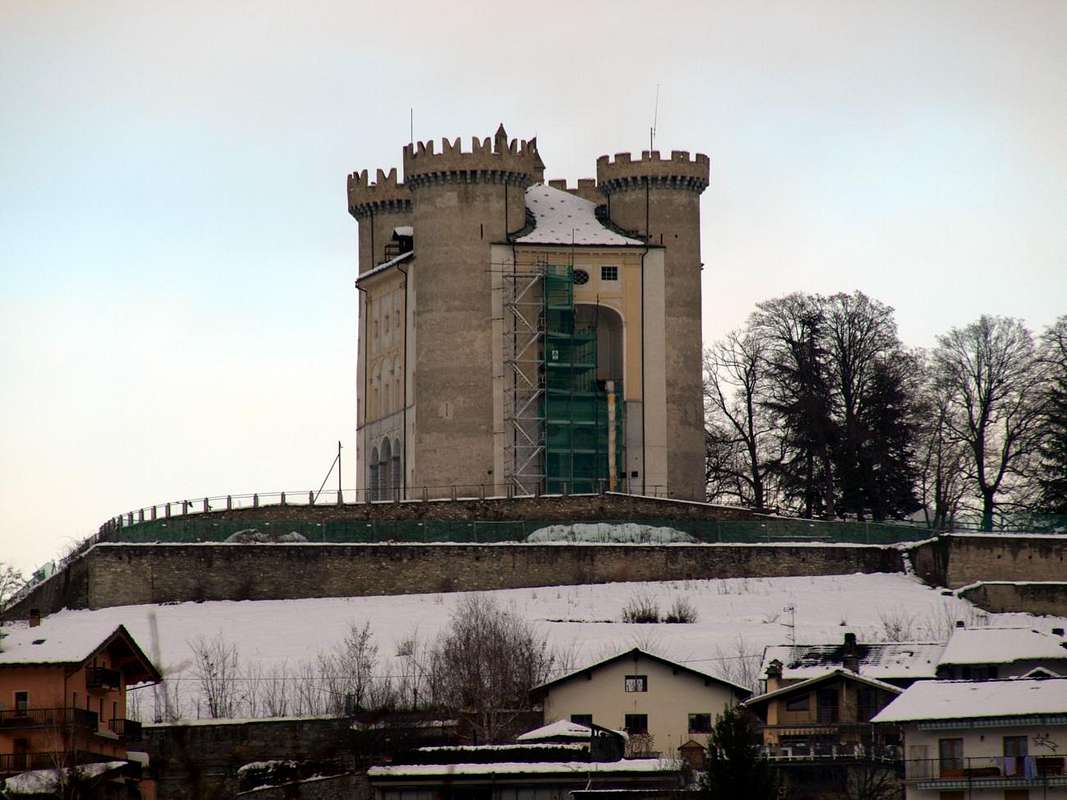
It should not be forgotten that these paths, especially those on the side of the Cogne Valley, are exposed and require prudence as well as a good knowledge of the not simple area; less demanding those on the opposite side or Villeneuve 's Municipality (therefore at the beginning of the Valsavaranche and Rhêmes Valleys), but also here it is necessary to know how to move and orient yourself. However, from the central square of Villeneuve (at the Church of Santa Assunta) there are indications (also for the visit of the above Chatel Argent). While an asphalted road reaches, starting from the crossroads 647 meters at the locality of Chavonne and passing through the Hamlet of Côte (757m), also from this side the two farms of Issogne (851m). However, wanting to make a complete excursion on foot, it is better to keep on the path n ° 2 which runs along the entire gorge just above it. From below, starting precisely Aymavilles little Town, at the location of Moulin. While it is absolutely not worth venturing outside of these indications ...
![]()
Mont de Poignon (1567m) almost complete Eastern Side above Grand'Eyvia Torrent
by Osw October 2016
Abbiamo già parlato di Pondel o, più anticamente, Pont d'Ael, una piccola frazione del Comune di Aymavilles ( 646 metri e a 7,4 kilometri ad Ovest della Città di Aosta); tanto piccola ed ai più sconosciuta quanto antica. Sicuramente già abitata dal Popolo Salasso prima dell'arrivo dei Romani che, fondata la Città di Aosta o, meglio, Augusta Praetoria Salassorum, nel 25 avanti Cristo, a poco a poco incominciarono ad appropriarsi anche del circondario. Quella era una storia che riguardava esclusivamente la costruzione dell'antico ponte sopra il fiume Grand Eyvia che scende lungo tutta la Valle di Cogne (vedi l'articolo del 6 Gennaio 2016: "Archeo / d True History of Channel Pont d'Ael (Pondel) to Châtel Argent between Aymus et Avilius (Aymavilles) & Villeneuve"); questa invece vi vuole parlare e descrivere la gola selvaggia con il suo burrone che precede l'abitato di Pondel (893 m), incassato in una forra alle pendici del Mont Poignon o Mont de Poignon (1567 m). Questa risulta essere la prima montagna sopra il Comune di Villeneuve (670metri e 10 kilometri ad Occidente da Aosta) di quel lungo spartiacque che dal fondovalle raggiunge dapprima le due splendide piramidi del Grand Nomenon o, anticamente per i locali la "Gran Punta", (3488 m) e della La Grivola (3969 m); nonché, al suo termine Meridionale, il Gran Paradiso (4061 m), dividendo la Valle di Cogne e separando la medesima da quella ad Ovest attigua di Valsavaranche (meglio che non Valsavarenche alla francese, poiché il torrente principale si chiamava e si chiama Savara e non Savare). Il Torrente Grand Eyvia che da Cogne scende verso Nordovest, dapprima con un percorso "tranquillo" si tramuta, strada facendo e superate le Frazioni di Crétaz (1494 m) ed Epinel (1432 m), in un corso d'acqua sempre più ripido ed impetuoso, tale da costringere la Strada Regionale ad abbarbicarsi in alto attraverso le foreste Meridionali ai piedi della selvaggia Punta del Trayo o Tradzo ed anche Trajo o Traso (3127 m) e del successivo, dopo i Villaggetti di Senayet (1287 metri, a Nord del fiume), Sylvenoire (a Sud) e Charossaz (1183 metri, di nuovo a Nord dello stesso), Vallone del Grand Nomenon. Prendendo origine dall'ultima frazione di Aymavilles ovvero Vieyes (1132/58 m), posta al confine con il Comune di Cogne.
![]()
Pont d'Ael or Pondel Bridge to Grand'Eyvia Gorge at the feeth of La Grivola (3969m)
by Osw January 2016
Da questo punto il Torrente della Grand Eyvia (Grande Acqua), nel suo corso sempre meno "tranquillo" nonché "scontrandosi" con le rocce terminali della piccola Becca Plana (2296 m) ed anche sospinto, dopo quello di Grand Nomenon presso ed ad Oriente dal Villaggio di Vieyes, dai Meridionali Torrents de Beligny e Grand Creton, diventa dapprima "scontrosa" iniziando a flettere e sbattere la testa verso Nordovest e poi, entrando in conflitto con le dure rocce del Grand Poignon (1571 m), "stizzita" piega decisamente a Settentrione lasciandosi alle spalle il Pont de Chevril (961 m) e l'omonimo villaggetto (967 m). Oltre, scartato dabbasso il soprastante Villaggio di Sérignan ormai nella Conca di Ozein, tramite un doppio ed aspro cambio di direzione si dirige "rabbiosa" verso la Frazione di Pondel o Pont d'Ael (893 m) ed il suo ponte romano del 3 avanti Cristo o, se volete, dell'anno 750 di Roma, "ab urbe condita" ... La storia di Pont d'Ael, francesizzato in patois locale come Pondel, ci racconta di questo grande cimelio, atto anche qui a testimoniare la grandezza di Roma antica, sospeso ad oltre cinquanta metri sopra il letto del torrente; una doppia copertura o meglio un doppio passaggio con uno coperto e l'altro scoperto lo caratterizza. Il primo serviva per fare scorrere l'acqua di irrigazione e non solo (vedi l'articolo citato), mentre l'altro veniva utilizzato per il transito di persone e bestiame in una larghezza di metri 1,08, che diventa di 2,26 comprensivi delle murature laterali. La differenza di altezza tra i due passaggi é di 4, 12 metri, mentre la lunghezza del medesimo risulta uguale all'altezza complessiva sulla Grand Eyvia (circa 50/2 metri).
![]()
From South towards Pondel 's Ravine below East-northeast rocky Face of Mont de Poignon and along Grand'Eyvia Torrent
by Osw October 2015
Raggiunto, con una discesa dalla Strada Regionale per Cogne, in auto il Villaggio di Pondel (piccolo parcheggio subito nelle vicinanze della Chiesetta di Sant'Andrea), con una breve discesina a Sudovest si raggiunge il ponte, dal quale é possibile ammirare l'Orrido di Pondel, le acque del quale si fanno largo incidendo e ferendo la roccia. Una roccia che si protende verso il basso con un urlo prepotente, atto quasi a denunciare le ferite subite nel corso dei millenni. Dire che sia possibile percorrere questo stretto canyon é cosa azzardata, mentre possiamo affermare di come lo si possa ammirare, oltre che dal ponte, sul lato Orientale, parzialmente, dalla Strada Regionale verso Cogne; mentre su quello opposto lo percorre un sentiero ardito, il n° 2, che sinuosamente ed in parallelo risale dalle due fattorie di Issogne (851 metri e "distese" al margine inferiore dei prati in una zona sicuramente meno dirupata) fino a Pondel, donde un altro numerato 3 risale verso Sudovest i ripidi pendii erboso-rocciosi che raggiungono il Casotto del P.N.G.P. (1559 m) del minuscolo Alpeggio del Petit Poignon (1540 m). Sullo stesso sentiero, raggiunta l'altitudine di 1130 metri circa, una deviazione si dirige a Sud-sudest raggiungendo con sentierucolo non numerato l'Alpe di Charpinel (1186 m) posta proprio a piombo del Ponte di Chevril e dalla quale di può ammirare l'intera gola rocciosa. Continuando invece con il medesimo, ma maggiormente verso Ovest-sudovest, si arriva a quello del Grand Poignon (1571 m), località alla quale perviene anche una strada dapprima in asfalto e poi poderale che dal bivio 680 metri dopo l'ex Fornace risale la collina subito alle sue spalle passando per le Frazioni di Martignon (823 m), San Bernardo (840 m), Bertola, Bruillen, Champlong Dessus (995 m); da questo punto si trasforma, concomitante al sentiero n° 1, in strada poderale che raggiunge le Alpi Prorayé (1273 e 1330 metri circa). Qui perviene anche il sentiero n° 2A che, partendo invece da Aymavilles, percorre l'intero spartiacque passando per Champleval Dessous (935 metri, di Sotto) e Dessus (1057 metri, di Sopra) e raggiungendo l' Alpe di Prorayé Damon (1330 metri circa, sempre di Sopra). Anche questo percorso risulta panoramico, ma principalmente sulla parte inferiore della gola rocciosa.
Non si deve dimenticare che questi sentieri, soprattutto quelli sul lato della Valle di Cogne, sono esposti e richiedono prudenza oltre ad una discreta conoscenza del territorio; meno impegnativi quelli sul versante opposto ovvero di Villeneuve (quindi all'inizio delle Valli della Valsavaranche e di Rhêmes), ma anche qui é necessario sapere come muoversi ed orientarsi.Comunque dalla piazza centrale di Villeneuve (presso la Chiesa di Santa Assunta) esistono indicazioni (anche per la visita del soprastante Chatel Argent). Mentre una strada asfaltata raggiunge, partendo dal bivio 647 metri presso la località di Chavonne e passando per la Frazione di Côte (757 m), anche da questo lato le due fattorie di Issogne (851 m). Però volendo fare un'escursione completa a piedi conviene tenersi sul sentiero n° 2 che percorre l'intera gola appena al di sopra della stessa.Dal di sotto partendo appunto dal Comune d'Aymavilles, presso la località cosiddetta di Moulin. Mentre non conviene assolutamente avventurarsi al di fuori di codeste indicazioni ...
![]()
From Pondel 's Bridge (880m) Southern Side above the Grand'Eyvia Torrent
by Osw October 2016
Getting There
By car:
By plane:
- From TORINO, MILANO, etc: Motorway A5. Exit at IVREA or Quincinetto (PIEDMONT)
AOSTA West/Aymavilles, Cogne Municipalities.
![]()
From Aymavilles (646m) towards Cogne Valley: Vieyes (1132m) towards Epinel, Crétaz Hamlets and Cogne (1534m); through Main Road. From Eastern Cogne Resort, near the triple crossroads (Lillaz, Colonna, Gimillan) to Montroz (1702m) and Gimillan (1785m) Villages. All the three last through Regional Roads from Cogne.
Specific Roads to Artistic Center of Cogne
Wanting to "widen" your trip to the Cogne Valley, in addition to visiting Podel or Pont d'Ael: from Cogne's Center or through the North Ring reach the triple alternative (about 500 metres). Leaving right (East) the deviation to Moline and Lillaz Hamlets and abandoning left (Northwest) the Regional Road towards Montroz and Gimillan Villages, continue briefly with a secondary deviation to the left (North) reaching the Cogne's Miners Village (1626m). Or continuing through the last Regional Road until the second semi diagonal in Northeast followed by a short descent towards the Miners Village.
- From FRANCE: through the Mont Blanc Tunnel to Entrèves-crossroads to Vény/Ferret Valleys - Mountain Guides of Courmayeur - La Saxe Rock Gym - Courmayeur.
![]()
By Little Saint Bernard Hill, closed since November until half May to La Thuile Valley - Pré Saint Didier - Courmayeur.
It is not necessary to take Motorway A5: you can drive on State Road n° 26, in the direction of AOSTA - IVREA - TURIN.
By plane:
- Aeroporto Internazionale "Corrado Gex" Saint Christophe (Aosta)