
-
 25554 Hits
-
 88.61% Score
-
 27 Votes
|
|
Area/Range |
|---|---|
|
|
35.26390°N / 120.8622°W |
|
|
Hiking |
|
|
Spring, Summer, Fall, Winter |
|
|
Overview
Montaña de Oro State Park is located six miles southwest of Morro Bay and seven miles south of Los Osos on the Central California Pacific Coast. Montaña de Oro is one of the largest state parks in California. Close to a million people visit Montaña de Oro each year. It features rugged cliffs, marine terrace bluffs, secluded sandy beaches, coastal plains, streams, canyons, and hills, including the 1,347’ Valencia Peak. Naturalists and backpackers enjoy the solitude and freedom found along the park’s trails. There are also mountain biking and equestrian trails. The best-known beach is Spooner’s Cove, across from the campground. The park’s name, "Mountain of Gold," comes from the golden wildflowers that bloom in spring. Wildlife in the park includes black tailed deer and the black oystercatcher. The park includes primitive and equestrian campsites.
Description

Montaña de Oro State Park lies just south of Morro Bay. Its wave swept, seven-mile long shoreline is made up of sandy beaches along the sand spit to the north, and rugged cliffs and headlands to the south. The central and southern part of the park features a number of small coves with sandy beaches, the most prominent and accessible of which is Spooner's Cove. Inland from the shoreline is an ancient wave-cut terrace that was long ago uplifted from the cutting edge of the surf and now appears as a grass covered coastal plain. The plain sweeps back from the ocean and then curves up sharply upward to 1,500 foot high hills including Valencia Peak from which one can overlook nearly a 100 miles of the coastline from Point Sal in the South to Piedras Blancas in the north.
California live oak and Bishop pine occur in the chaparral covered hills, and there are willows, big-leaf maple, box elder, myrtle and black cottonwood trees in the stream-cut canyons. Trails have been developed throughout this uplifted area and hikers are welcome to explore all parts of the park. Motor vehicles must remain on the paved roads. The park includes more than 8,000 acres, is largely undeveloped, and features a wide range of wildlife including rabbits, squirrels, skunks, raccoons, badgers, deer, fox, bobcats, coyote, and even an occasional mountain lion. There are also many kinds of birds, and in the spring and early summer a brilliant display of wildflowers. It was the predominantly yellow color of these flowers that inspired the naming of this area - Montaña de Oro or Mountain of Gold.
A unique feature of Montaña de Oro State Park is the long sandspit that separates Morro Bay from the ocean. Made up of successive rows of sand dunes, some of which reach 85 feet in height, the sandspit can currently be reached by boat or by way of the access road approximately one mile inside the entrance to the park. Due to its remoteness, the sandspit is an excellent place for beach combing, surf fishing, bird watching, and other daytime activities. Camping is not permitted.
At the park headquarters in the old Spooner Ranch House, located just above Spooner's Cove, you can get camping and park information. Docents of the Natural History Association (NHA) operate a Visitors Center which is open on weekends and daily during the summer months.
Horse Facilities: For those who wish to bring horses to the park and camp overnight, there are five horse camps for family and group outings, complete with pipe corrals and plenty of parking for horse trailers. No horse rentals are available. Hazard Canyon horse camp can be reached by turning east off of Pecho Valley Road just inside the northern boundary of the park. Follow the dirt road one-half mile down into the horse camp. There are two group camps and three individual horse camps. Tables, woodstoves, pit toilets, and corrals are provided. Trails out of the horse camp connect with Montana de Oro's parkwide trail system.
Day Use: Day use facilities with picnic tables and woodstoves are available at Spooners Cove, Coon Creek and adjacent to the park office. Pit toilets are located nearby. Swimming, fishing, hiking, bicycle and horseback riding are popular activities in this area. Approximately fifty miles of trail are maintained for the benefit of hikers and horseback riders. Lifeguard service is not provided.
Nature Guided Walks and Programs: For those interested in the natural history of the park, regular campfire programs are given during the summer by the ranger staff. Walks are also given year-round. Check the bulletin board at the Ranch House for dates and times, or call the Morro Bay Museum of Natural History at (805)772-2694.
Pecho Road
Los Osos, CA 93402
(805)528-0513
50 Campsites
Water, Pit Toilets
Campground Reservations: MISTIX
800-444-7275
Geological History
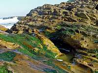
The prevailing rock of the park is Monterey Shale. Formally ancient sea floor, it is composed of mudstone deposited millions of years ago when the fragments of once-living organisms drifted to the bottom and mixed with silt and sand. The mud solidified into thick layers of diatomite, clay porcellanite, dolimite, and chert. Near the unstable western coast of this continent the Pacific Plate grinds against the North American Plate. This action has buckled and tilted the sedimentary layers, raising them out of the sea. Over time, erosion and wave action turned them into a sloping beach. The level of the ocean also changed as ice ages came and went. This process has been repeated several times over the past five to ten million years. You can see the successive marine terraces (former beaches) as you hike on the present bluff or climb the slopes of Valencia Peak.
Human History
Five hundred years ago: When Europeans first arrived on the California's central coast, they found it inhabited by the Chumash Indians. An estimated 20,000 to 30,000 of them lived in small villages spread over a territory which extended from Morro Bay south to Malibu. Although the Chumash depended heavily upon the sea, they also drew on many other sources for food, clothing, and shelter, and were probably part of a large trading network. The Spanish Explorers who visited the Montaña de Oro area in 1542 recorded that the Indians were attractive, friendly people who paddled out to greet them in canoes.
Two hundred years ago. In 1769, Don Gaspar de Portola marched his troops north from San Diego to establish new territory for the king of Spain. With the beginning of the Mission period, the Indians were moved inland, and this was the beginning of the end for the Chumash. Most died from European diseases to which they had no immunity. The survivors abandoned their villages and disappeared. With them, their customs, heritage and culture all but vanished as well. Traces of Chumash village sites can still be seen in the park, but our knowledge of their culture remains sketchy. For this reason, and so that others may enjoy them, it is against the law to tamper with or disturb any Indian sites.
The last hundred years. The property rights for the Montaña de Oro State Park land area changed hands several times after California became a territory of the United States. It was used mostly for grazing sheep until 1892, when Alden B. Spooner, Jr., leased the land he later purchased around Islay Creek. He brought in dairy cattle, hogs and other agriculture. His two sons founded the Pecho Ranch & Stock Co., and built a ranch house, a complex of barns, a creamery, stables, sheds, and a waterwheel for power. On the south bluff of Spooner's Cove they utilized a warehouse with a long chute that led down to a wharf and a loading boom to service coastal steamers. The land just to the north was owned by Alexander S. Hazard, who also raised crops and maintained a dairy. Hoping to cash in on California's growing need for timber, he planted hundreds of eucalyptus trees, turning Hazard Canyon into a prospective lumber farm. Unfortunately, eucalyptus proved unsatisfactory for commercial use. In the early 1940's, a flood scoured Hazard Canyon, and in 1947 a grass fire burned up the coast from Diablo Canyon, destroying much of what had been the Hazard dairy buildings. However, Hazard's legacy, the rows of eucalyptus trees, remains. Rancher Oscar C. Fields bought the land in the early 1940's, but sold it to Irene McAllister about ten years later. In 1965 the property was purchased by the State of California for a state park, and it was decided to keep the name McAllister had given it "Montaña de Oro".
Hiking

A few selected trails:
Birding Islay Creek (~2.5 miles): A hike up Islay Creek passes through four habitat zones: conifer forest, riparian, chaparral and coastal scrub.
Bluff Nature Walk (~4 miles): Beautiful, easy hike along the Bluff Trail for magnificent views. A large variety of birds, plants and sea life can usually be seen; binoculars are helpful.
Rattlesnake - Coon Creek Loop (~3 miles): Gorgeous ocean views along the Rattlesnake Flats trail and return via a lush streamside environment (Coon Creek trail). You encounter three contrasting natural communities: coastal sage scrub, chaparral and riparian woodland.
Reservoir Flats Trail (~ 2 miles): Beautiful hillside trail with ocean views and lush creekside greenery. You will see a great variety of plants.
Valencia Peak (1,347’; ~4 miles): This hike leads from the coast inland to the top of Valencia Peak with marvelous views along the way. One can combine this peak with Oats Peak and Allen Peak, which lie further east. Climbing all three peaks will cover ~ 5-6 miles one way.
A beautiful half-day trail is from the Spooner’s Cove to Valencia Peak and further to Oats Peak. From Oats Peak you can take the Oats Peak trail until the junction with the Coon Creek trail. Follow the Coon Creek trail along beautiful riparian scenery until the junction with the Rattlesnake trail. Follow this trail over the ridge and back to the Valencia Peak trail and Spooner’s Cove. This loop is about 11 miles long and totals more than 2,500 feet elevation gain.
Please Remember:
Camping
Fifty campsites are situated along the south side of the creek behind the Ranch House. The sites are suitable for tents, trailers, or motor homes up to 24 feet in length. Tables and woodstoves are provided. Primitive toilets are located nearby, but there are no showers or dump stations. Some people may prefer the walk-in environmental campsites, which are more secluded and perhaps more peaceful, but should not be surprised to wake up to the yapping of coyotes or the rustling of other nighttime creatures.
Getting There

Montaña de Oro is located at the end of Pecho Road near Los Osos, California. From Highway 101, take the Los Osos Valley Road Exit just south of San Luis Obispo. Drive approximately 12 miles on this road until you reach the Ranger Headquarters and Visitor Center, adjacent to Spooner's Cove.
Weather
External Links
Montaña de Oro State Park 1
Montaña de Oro State Park 2
Montaña de Oro State Park 3