
|
|
Mountain/Rock |
|---|---|
|
|
37.12311°N / 118.46642°W |
|
|
Inyo |
|
|
Mountaineering, Skiing |
|
|
Spring, Summer, Fall, Winter |
|
|
11617 ft / 3541 m |
|
|
Overview
Mount Alice is a rather diminutive mountain compared to other giants in the area, but is a worthy climb due to its outstanding panoramic views of both the north and south fork Big Pine Creek basins. Alice is located within a short distance of the Big Pine Creek Trailhead, making it ideal for early season treks or short day trips later in the season. It is commonly climbed with the neighboring and slightly higher Buck Mountain to the south.
Getting There
From Big Pine, follow Glacier Lodge Road until it dead ends at the Big Pine Creek Trailhead. The road may be gated at Sage Campground during winter, adding about 1.5 miles each way.
Route
5.5 miles RT, 4000' gain
From the Big Pine Creek Creek Trailhead, follow the main trail about a quarter mile before reaching a junction. Take a left to get on the South Fork trail. Stay on the trail for 3/4 of a mile, reaching an approximate elevation of 8250'.
Begin to look for the drainage basin between Buck and Alice to your right. In summer, this will be a sandy slope with some rather annoying shubbery. In winter, the gully should be an obvious snow chute.
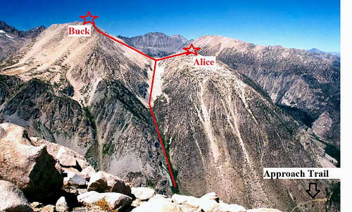
Route as seen from Kid Mountain
After 3/4 of a mile of moderate grade climbing, reach a "bowl" at 10,000'. If doing the climb in the summer, this is the point where you leave the shubbery behind. Enjoy a brief flatter grade until making the final push to the saddle between Alice and Buck.
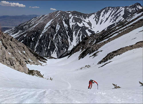
Final push to the saddle. May 4, 2019.
From the saddle head right (north) to the Alice summit. It is easy class 2 hopping on solid rock to the top.
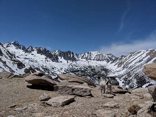
View from the saddle. May 4, 2019.
Red Tape
None.
When to Climb
Spring, Summer, Winter, Fall. It is probably best done as a spring snow climb when one can avoid sand and bushwacking.