-
 13055 Hits
-
 89.39% Score
-
 29 Votes
|
|
Mountain/Rock |
|---|---|
|
|
42.968°S / 171.54330°E |
|
|
Hiking, Mountaineering, Scrambling |
|
|
Spring, Summer, Fall, Winter |
|
|
6024 ft / 1836 m |
|
|
Overview

One of the more beautiful and accessible alpine areas in the South Island of New Zealand is Arthur's Pass National Park. Set in the Southern Alps on the road between Christchurch on the east coast and Greymouth on the west, this area and its 60-some peaks have been a climbing escape since 1891.
With glaciated peaks, tussocky hills and numerous waterfalls, Arthur's Pass is a draw for many. Named for surveyor Arthur Dobson who was checking out information from a Maori chief about a new way to the West Coast after gold had been discovered the year before in 1863, the road through was completed in 1866. At this time, the Superintendent of Canterbury, a land investor and one of the early settlers from England, Samuel Bealey, was involved with others in the area, namely William Rolleston and their names are now forever linked to this region. Mt. Bealey lies directly west from the pass and the town can be seen from the trail. Bealey is not glaciated but rather is on the south end of a ridge running southeast from Mt. Rolleston, the highest peak in the vicinity.
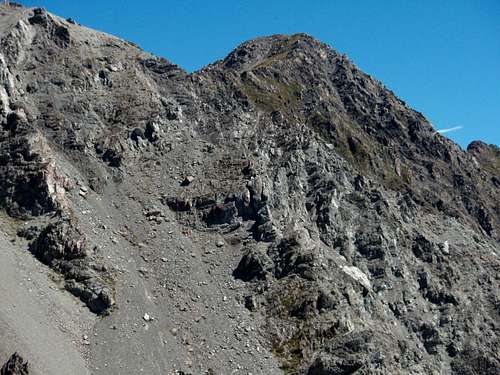
The summit sits at the junction of three separate smaller ridges.

To the north is a wonderful Class 3 ridge to Lyell Peak (photo above), to the south is a ridge descending to the Bealey River and to the east and curving northeast is the ridge down to Arthur's Pass. There are two established routes to the summit: one could traverse south from the region's most hiked peak Avalanche Peak, or, one could take the Bealey Track from the south end of Arthur's Pass up to where the trail gives way to a carined route to the summit. Both would be Class 3 with some hand scrambling involved, but nothing too exposed or serious. There are great views to the Shaler Range and higher Southern Alps mountains to the west. To the north sits Mt. Rolleston in its glaciated glory. To the east lies the precipitous Polar Range and to the south lies the valley to Christchurch. Falcons and Keas call the area home and the hike up takes one from the thick forest below up through thinning trees to open grassy slopes to the rocky crags and ridges of Mt. Bealey. To be sure, the hikes are steep but the payoff is one of New Zealand's gems and a great way to spend a day.
Getting There
There is but one way to get to this area by car. From the west or east, take Highway 73 to the town of Arthur's Pass. From Christchurch it is 150 kilometers or about 2 hours, from Greymouth it is 100 kilometers or about an hour and a half. You'll need to check in at the Department of Conservation in the middle of town on the west side of the road.If you are taking Scott's Track up to Avalanche Peak first and then traversing south to Bealey, that trailhead is found just north of town right next to a small waterfall and directly across the valley from the large Devils Punchbowl Falls. There is a green sign that marks this track.
If you are taking the Bealey Track up, this trailhead is found on the south end of town. Turn west of Mt. Bealey Road (near the sign for the police station) and go to road's end at the trailhead.

An alternative to auto travel is to take the TranzAlpine Train from Christchurch.
Red Tape

No real red tape as far as fees go (none). It is strongly suggested you check in with the Department of Conservation/Arthur's Pass Visitor Centre. There is a sign-in sheet and you can check on area and trail conditions, weather, get maps etc.
Arthur's Pass Visitor Centre
PO Box 8
Arthur's Pass
phone +64 3 318 9211
fax +64 3 318 9210
Camping
The Department of Conservation operates a system of 30 huts throughout the park. Contact them through their website or email them at arthurspassvc@doc.govt.nz for more information. The nearest shelter is the Crow Hut that lies in the valley west of Avalanche Peak.For accomodation in Arthur's Pass, you can check this website or I would recommend Arthur's Pass Alpine Motel for a nice clean, quiet place to spend the night before a climb. Say hello to the Jack Russel terrier the owners have there.
Mountain Conditions
Arthur's Pass WeatherBackcountry Avalanche Info
Track Conditions