
|
|
Mountain/Rock |
|---|---|
|
|
39.70941°N / 116.9509°W |
|
|
Lander |
|
|
Hiking |
|
|
Spring, Summer, Fall, Winter |
|
|
10187 ft / 3105 m |
|
|
bradb's picture at upper right
![Mount Callaghan (NV)]() Mount Callaghan
Mount Callaghan
![Summit of Mount Callaghan]() Summit area
Summit area
Thanks to a communications structure located near the highest point on this mountain which can be seen easily from highway 305, a road has been built which makes access easier. I will admit to being reluctant in putting up this page but my own experience of not knowing the correct roads to take (which led to gates marked with no trespassing) is one of the reasons I thought this information might be helpful to others who want to get this mountain crossed off of their list. The real value of this page is in nailing down the "legal" road route.
When snow still lingers on the upper mountain, it might be best to use snowshoes or backcountry skiis to reach the summit. Ken and I elected to make a 4 mile hike out of it by parking lower down and making our way to the summit from the spot we parked at. As a mountaineering challenge, this ranks very low on the scale of difficulty regardless of how you decide to deal with it. Enjoy the area and realize that the history is rich in the feel of the "old west". See more about that in the history section I have provided below.
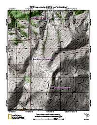
From Austin, go north on highway 305 from the junction of highways 50 and 305 toward Battle Mountain and after 16 miles or so, watch for the signed turnoff for the Silver Creek road (gravel). Take a right and travel a bit over 4 1/2 miles, watching for a left fork (not signed) that heads northeast. Follow this road for a bit over 3 1/4 miles and take the right fork which is the Bernd Canyon road. Follow this road as it makes its way northeast and which drops into Boone Canyon before making its way back up to a saddle at 7500 feet where you take a lesser road to the south. The road gets rougher and those without high clearance might find it best to park near this junction and walk from this point. Continue on until reaching the 9030 mark (see map) and this would be a great spot to park and hike up from. The road (if snow free) would take you to near the summit but the best way to feel like you've earned this one is to make a hike out of it. I have provided maps for these roads with
GPS waypoints to help you find your way.
![Area map]() Area map
Area map
Off of highway 305 (20+ miles south of Battle Mountain) is Mill Creek
South of Austin is Bob Scott Campground
Austin itself has several motels
![Fourth map]()
In case you can't read the waypoints on my maps
Waypoints:
001 = 39.71966 / 117.16764 4.6 m
002 = 39.69242 / 117.08963 3.3 m
003 = 39.72888 / 117.0528 5.2 m
004 = 39.7523 / 116.9669 2.0 m
005 = 39.72712 / 116.9631 2.3 m
"The town of Austin Nevada is more than just another stop along Highway 50, the Loneliest Road in America. This is a place to enjoy rugged and scenic trails, or soak in the warm, soothing waters of Spencer Hot Springs. Born an old-west town, Austin Nevada was home to some of Nevada's more colorful prospectors and silver miners. Today, with the expansive Toiyabe Mountain Range as its backyard, it features some of the best mountain biking, hiking and exploring in the state. Although rich in history, this town is not a "ghost town." Austin’s historic Main Street has motels, bed and breakfasts, RV parks, restaurants, gas stations and unique shops to visit. There are special events throughout the year, so check our calendar often as something new is always happening. Every season is special in Austin Nevada! Break away from the ordinary and treat yourself to the treasures of Austin Nevada."
Austin Nevada is one of my favorite towns in the west. I never get tired of visiting this one. The town will celebrate its 150th anniversary this year (2012).
"Austin's 150th Anniversary!
Austin is celebrating its 150th anniversary this year (1862-2012.) To celebrate this special event, we're compiling a list of 150 things to do "in and around Austin," all within a 60-mile radius. Check back often, we'll be posting three things to see and do, each week, for the entire year. We'll also post updates on FaceBook, our Blog, and right here on AustinNevada.com/anniversary. We'll feature driving tours, fishing spots, hunting locations, ATV trails, walking tours, local hangouts and favorites places, and anything that can be seen or done in Austin! "
Ken Jones has a nice GPX track here and SP member BradB has a trip report for a northern route here.
Birth: 1823
County Kerry, Ireland
Death: Aug., 1886
Lander County
Nevada, USA
Reno Evening Gazette
August 13, 1886
Fell From His Wagon
Daniel Callaghan who had been a resident of Grass Valley, Lander County over 16 years, took a load of potatoes to Austin, disposed of them and started for his home in the evening. Being his own worst enemy, on his way home, he fell from the seat and broke his neck, and two ribs, killing him instantly. Deceased was a native of Ireland and was 63 years of age, and leaves a wife and four small children.
Jessie Callahan was born in Austin, Nevada on May 17, 1887. Her parents were Eliza Farrell and Dan Callahan. Eliza had been born in Buenos Aires where her parents landed after leaving Ireland; they went around the Horn in a clipper ship and arrived in San Francisco to live. Jessie's father, Dan, was born in County Kerry, Ireland and came to Nevada in 1862, later homesteading his own land near Austin in Grass Valley.
Click for weather forecast

Click for weather forecast
 Mount Callaghan
 Summit area
 Overview
Mount Callaghan in central Nevada is close to Austin Nevada, located almost at the geographic center of the state. A round (kinda boring) shaped looking mountain, this one attracts attention from peakbaggers who chase the prominence peaks of the state of Nevada. Having 3027 feet of prominence puts it at #62 on the Nevada list and while it is relatively easy to summit, it is a long way from Reno, Las Vegas or Salt Lake City. Named for Dan Callaghan (see history below), the area around Austin still has a very "old" west feel to it. The fabled Pony Express ran by just north of Austin. Legend has it that the silver rush that caused Austin (named after Austin Texas) to boom was started by a pony express horse that kicked over a rock that had silver in it.Thanks to a communications structure located near the highest point on this mountain which can be seen easily from highway 305, a road has been built which makes access easier. I will admit to being reluctant in putting up this page but my own experience of not knowing the correct roads to take (which led to gates marked with no trespassing) is one of the reasons I thought this information might be helpful to others who want to get this mountain crossed off of their list. The real value of this page is in nailing down the "legal" road route.
When snow still lingers on the upper mountain, it might be best to use snowshoes or backcountry skiis to reach the summit. Ken and I elected to make a 4 mile hike out of it by parking lower down and making our way to the summit from the spot we parked at. As a mountaineering challenge, this ranks very low on the scale of difficulty regardless of how you decide to deal with it. Enjoy the area and realize that the history is rich in the feel of the "old west". See more about that in the history section I have provided below.
Getting There
Find your way to Austin, located in the center of the state with highway 50 providing access from the east or the west. From Battle Mountain and the interstate (I-80)to the north, utilize highway 305.From Austin, go north on highway 305 from the junction of highways 50 and 305 toward Battle Mountain and after 16 miles or so, watch for the signed turnoff for the Silver Creek road (gravel). Take a right and travel a bit over 4 1/2 miles, watching for a left fork (not signed) that heads northeast. Follow this road for a bit over 3 1/4 miles and take the right fork which is the Bernd Canyon road. Follow this road as it makes its way northeast and which drops into Boone Canyon before making its way back up to a saddle at 7500 feet where you take a lesser road to the south. The road gets rougher and those without high clearance might find it best to park near this junction and walk from this point. Continue on until reaching the 9030 mark (see map) and this would be a great spot to park and hike up from. The road (if snow free) would take you to near the summit but the best way to feel like you've earned this one is to make a hike out of it. I have provided maps for these roads with
GPS waypoints to help you find your way.
 Area map
 Red Tape
If you get off the main road route described above, you will run into gates that are marked for "No trespassing". Otherwise, the route we found was problem free, all the way to the summit.Camping
You could probably find car camping possibilities near the mountain but I would limit those to places where it is obvious that others have camped before. Much of the area is private ranchland and being able to determine the difference between private and public might be problematic. Campgrounds in the area are few and far between but the following are a couple possibilities:Off of highway 305 (20+ miles south of Battle Mountain) is Mill Creek
South of Austin is Bob Scott Campground
Austin itself has several motels
Maps & waypoints
 |  |  |
In case you can't read the waypoints on my maps
Waypoints:
001 = 39.71966 / 117.16764 4.6 m
002 = 39.69242 / 117.08963 3.3 m
003 = 39.72888 / 117.0528 5.2 m
004 = 39.7523 / 116.9669 2.0 m
005 = 39.72712 / 116.9631 2.3 m
Austin Nevada
From the website for Austin Nevada, consider the following:"The town of Austin Nevada is more than just another stop along Highway 50, the Loneliest Road in America. This is a place to enjoy rugged and scenic trails, or soak in the warm, soothing waters of Spencer Hot Springs. Born an old-west town, Austin Nevada was home to some of Nevada's more colorful prospectors and silver miners. Today, with the expansive Toiyabe Mountain Range as its backyard, it features some of the best mountain biking, hiking and exploring in the state. Although rich in history, this town is not a "ghost town." Austin’s historic Main Street has motels, bed and breakfasts, RV parks, restaurants, gas stations and unique shops to visit. There are special events throughout the year, so check our calendar often as something new is always happening. Every season is special in Austin Nevada! Break away from the ordinary and treat yourself to the treasures of Austin Nevada."
Austin Nevada is one of my favorite towns in the west. I never get tired of visiting this one. The town will celebrate its 150th anniversary this year (2012).
"Austin's 150th Anniversary!
Austin is celebrating its 150th anniversary this year (1862-2012.) To celebrate this special event, we're compiling a list of 150 things to do "in and around Austin," all within a 60-mile radius. Check back often, we'll be posting three things to see and do, each week, for the entire year. We'll also post updates on FaceBook, our Blog, and right here on AustinNevada.com/anniversary. We'll feature driving tours, fishing spots, hunting locations, ATV trails, walking tours, local hangouts and favorites places, and anything that can be seen or done in Austin! "
Others that visit the summit
We found a limited register on top with a few signatures of folks we knew. Peakbagger has a list of 6 people that have listed this mountain and I know of one other person who has visited the summit (he walked up from the 7500' level). With a road to the top, I'm sure many locals and hunters have visited this lonely summit (and I should mention windswept) since the wind about blew us off the thing. An up to date listing of those who have found the summit of this mountain is found at peakbagger.com.Ken Jones has a nice GPX track here and SP member BradB has a trip report for a northern route here.
History of Dan Callaghan
Dan Callaghan came to the Mount Callaghan area in 1863, prospecting for silver and gold. He located a claim on the southeast slope of the mountain that ended up with his name but the fertile land in the canyon proved too tempting for the country raised Irish lad to resist so he abandoned his mine and took up a homestead in the heart of a high meadow. He sent for his wife and they settled in a house he built on the bank of a creek. Everything in the south end of Grass Valley was named after him: Callaghan Creek, Callaghan Canyon, Callaghan Spring and of course, Mount Callaghan. (this information from the book "Here is our valley" by Molly Knudtsen)In 1863 Dan Callaghan was one of the men who came to search for gold and silver in Grass Valley. He staked a mining claim on the side of a mountain that was named for him, Mount Callaghan, and built the Callaghan Ranch. Although Callaghan died fairly young, his family kept the ranch for almost a century.Birth: 1823
County Kerry, Ireland
Death: Aug., 1886
Lander County
Nevada, USA
Reno Evening Gazette
August 13, 1886
Fell From His Wagon
Daniel Callaghan who had been a resident of Grass Valley, Lander County over 16 years, took a load of potatoes to Austin, disposed of them and started for his home in the evening. Being his own worst enemy, on his way home, he fell from the seat and broke his neck, and two ribs, killing him instantly. Deceased was a native of Ireland and was 63 years of age, and leaves a wife and four small children.
Jessie Callahan was born in Austin, Nevada on May 17, 1887. Her parents were Eliza Farrell and Dan Callahan. Eliza had been born in Buenos Aires where her parents landed after leaving Ireland; they went around the Horn in a clipper ship and arrived in San Francisco to live. Jessie's father, Dan, was born in County Kerry, Ireland and came to Nevada in 1862, later homesteading his own land near Austin in Grass Valley.
Weather for Austin Nevada
Click for weather forecast
Click for weather forecast