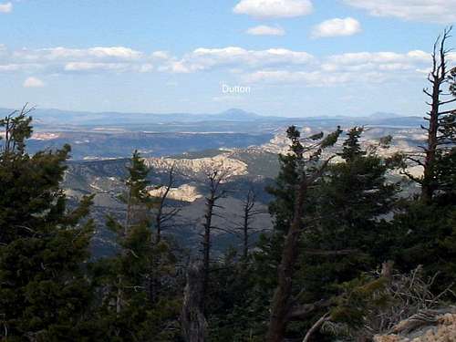
![Dutton Peak & Bryce Canyon (UT)]() Cedar Breaks
Cedar Breaks![Mt Dutton (UT)]() Mt Dutton
Mt DuttonWith my son
This is a little belated in getting posted but with the snow on the ground here in Lehi this morning, it seemed like a good idea to get caught up on some items that I had been meaning to get around to for awhile. In 2006 I had a great three day trip with my son and we enjoyed visiting some of the county highpoints in southern Utah together. After knocking off the toughest of the three that we did,
Signal Peak (see trip report) outside of St. George, we spent our last day of vacation being tourists, enjoying the offerings of beautiful Bryce Canyon and then taking a slow way home to Salt Lake, where my son lived at the time.
Our "slow" way was via Mount Dutton, one of Utah's prominence peaks that has over 4000 feet of prominence and is a mountain that is over 11 thousand feet high. This was an interesting detour as it took us through a badly burned forest, and then back to Salt Lake via
Antimony and
Big Rock Candy mountain.
Brad, this trip report is for you.
August 18th -On the way to Bryce Canyon
Brad and I had stopped in Cedar City and stayed at the Day's Inn in that fair town. We had spent the previous night in the campground at Oak Grove Campground below Signal Peak and were glad to get some good food and some good beds in Cedar City. From Cedar City on the morning of the 18th, we headed back up the road to
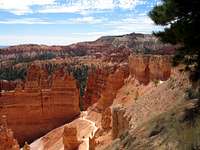
Cedar Breaks National monument and spent some time enjoying the great views and the great weather. Then it was on to Bryce Canyon via
Red Canyon and some sightseeing at several of the famous viewpoints that are really popular, with Sunset Point my personal favorite. One of the things I had wanted to do was to go and pick up the highest point in Bryce Canyon National park but that would have to wait for another day since they were paving the road and had closed that portion of the park to traffic. That was when I got the brilliant idea of going to Mount Dutton instead. Now in 2006 I was more into chasing the county highpoints of Utah than chasing after the prominence peaks but happily, that is now my main goal and it was nice to pick up Dutton at that time.
![Dutton Peak trip]() Cedar Breaks National Monument
Cedar Breaks National Monument
Brad and I avoided the "hiking" aspect of Bryce since the 4000 foot effort on Signal Peak the day before was enough for the both of us. It appeared that Mt. Dutton had a road right up to the summit and so that looked pretty appealing. What we were to find out was that the road in was a bit more of an adventure than we would have expected.

Bryce Canyon and onward to Dutton Peak
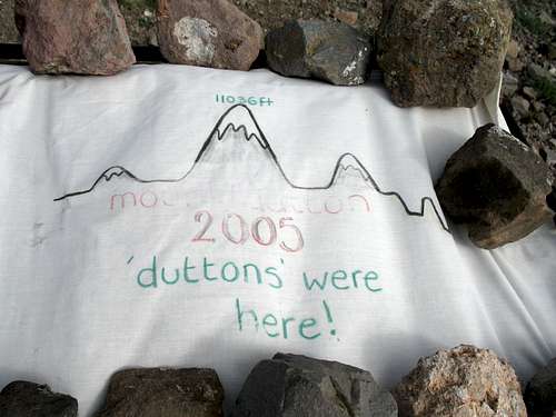
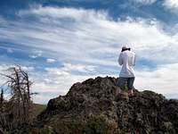
![Dutton Peak (UT)]() The Duttons were here
The Duttons were here
After a nice late lunch at Ruby's Inn at Bryce Canyon , we headed on our way north via highway 22. Finding FS road 125 heading west on Cottonwood Creek was our key turnoff and we followed this dirt road the rest of the way up onto the Sevier Plateau although we were almost stopped by two things that had happened in the previous year. A huge fire had devastated thousands of acres and blackened trees were everywhere. We came to a bridge over Cottonwood Creek only to find out there was no bridge at the time, it had been lost in the fire but the forest service was busy repairing the damage and they allowed us progress across the creek on a makeshift road they had built. A ranger was there and shared road information with us regarding our destination of Mt. Dutton. She said they were keeping the road open all the way to Mt. Dutton but that after every storm they had to go up and clear off dozens of trees that would fall across the roadway. She said if there was any downed trees blocking the way that we'd be forced to come back the way we came and go in from Antimony, which didn't have a tree fall problem.
We found our way without incident, passing to the west of Cottonwood Peak. The ranger had informed us about the sharp angle in the road that accessed Mt.Dutton and where to look for it and thanks to her spot on directions, we
had no problem finding that sharp turn off. About 3/4 of a mile from the summit, we were stopped by a big tree that had fallen across the road so we hiked the remainder of the road from there. A note in the register by Andy Martin indicated that that same had been there two years before. (Same elevation)
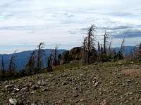
The road walk was good for us and eliminated the guilt I always feel about driving to the top of a mountain. On top we found a communications tower and a shed. Nearby was a cloth banner on the ground (see pic) that indicated that a family with the Dutton name had been up there the year before as part of a family reunion event. The actual highpoint itself was about 150 yards to the northwest and was part of a rocky outcrop. A benchmark, register and witness benchmark were located on the rock. As you can see from the pictures, it is not a lofty summit but at least it was separate from the communication tower set up. Some nice views from the summit to the northwest, west and southwest were available but views to the northeast and east were blocked by some local trees. Those trees were all
dead but not from fire, probably they died due to insect infestation.
After we visited the summit, found the register bottle and signed in, made a couple cell phone calls, it was time to leave. We made our way back to my truck and drove out via the north route in from Antimony. We were surprised by all the trailers we saw on the north side of the mountain and found it was a good 20 miles of dirt road to the town of Antimony. From Antimony, we made our way west and north, going past the Piute Reservoir and Big Rock Candy mountain before hooking back in with I-70 and our way back to Salt Lake City.
A great trip with my son and as it turns out, nice to pick up Mt. Dutton as dessert along the way.
From the summit area
![Dutton Peak (UT)]() Looking south
Looking south![Dutton Peak (UT)]() Looking west
Looking westPic of Dutton Peak
I really don't have a good picture of Dutton Peak from an angle that shows the mountain off and most likely it is more impressive from the west. If any of you reading this have such a picture and would be willing to share it, please add it to the image section. It will make a good signature picture and will be appreciated.
A bit more about Dutton Peak
From the
Utah forests page comes the following info:
Sevier Plateau / Mount Dutton
Description
Utah Forest Wilderness Photo
Smith Canyon, Casto Bluff Proposed Wilderness
The Sevier Plateau, commonly known as Mt. Dutton, is located on the Powell Ranger District of the Dixie National Forest. Striking volcanic peaks, plugs, necks and canyons top colorful sedimentary features found in the Red Canyon and Casto Bluff area. Pink and white limestone cliffs capped with sandstone conglomerates of the Wasatch formation define the dramatic scenery in the southern portion of the area. The land rises to reveal remarkable green cliffs, capped with tuffaceous volcanic flows. The scenic uplift that defines the peak of Mt. Dutton is visible from a great distance to the west, and provides striking views from the community of Panguitch. The general area contains the following roadless areas: Casto Bluff, Horse Valley, Deer Creek, and Blind Spring Mountain. The preceding areas contain 202,000 acres proposed for wilderness protection.
Location
The easiest access to the proposed Sevier Plateau Wilderness is from Highway 12, a scenic byway, as it climbs through Red Canyon. At the top of Red Canyon, travel into the interior of the area can be accomplished on forest road 117 to the north, then forest road 120 up Tent Hollow to the Casto Bluff area. The core of the area is approximately 15 miles northeast of the community of Panguitch, Utah. Access from Panguitch is via low standard dirt roads up the Right Fork of Sanford Creek. This route provides excellent views of Blind Spring Mountain and Hancock Peak. Another way to reach the core of the area is via a loop route on forest road 125. Beginning in the community of Antimony, to the northwest of the area, the route climbs through the pinon/juniper zone, sage steppe, aspen, and then spruce/fir forests near the high point of Mt. Dutton. The route continues the loop past Adam's Head, a J.W. Powell survey point, down through the successive life zones, ending in John's Valley at highway 22. Recent fire in the area provides an opportunity to see vigorous aspen regeneration, with prolific suckers sprouting even in the middle of the main road. Forest road 125 provides access to many fine hiking trails, some of which can stretch into multi-day backpacks.
Links
Mt. Dutton on Peakbagger.com


Comments
Post a Comment