
|
|
Mountain/Rock |
|---|---|
|
|
37.47145°N / 117.3728°W |
|
|
Esmeralda |
|
|
Scrambling |
|
|
6412 ft / 1954 m |
|
|
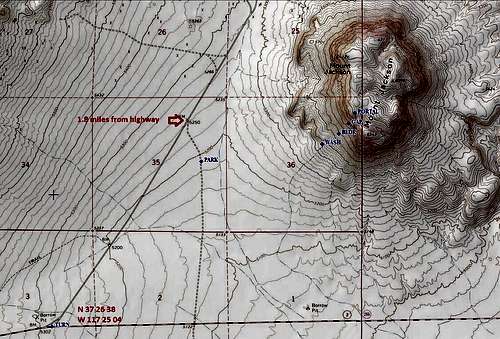 Topo map of the area, showing the turnoff from Hwy 266; the right turn onto the secondary dirt road; and approximate parking.
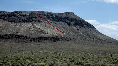 The route up the mountain, as seen early in the approach hike.
 This pic shows some key features along the route. The red circle marks a big boulder that is your first target. The red star marks a gap in a gray rock band. And the red arrow points to a little opening or portal that lets you out right onto the summit plateau.
 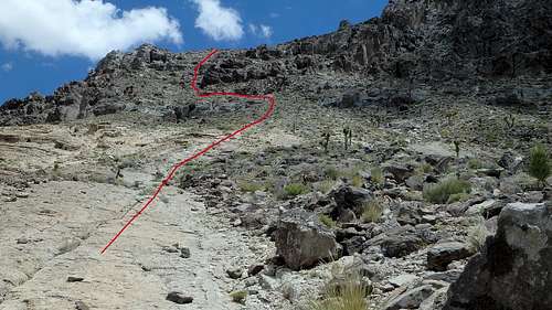 This pic shows the view from the boulder. From here, head up toward your next target which is the gap in the gray rock band.
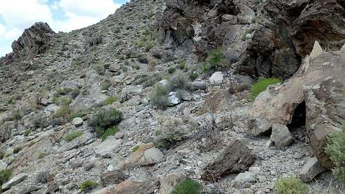 This pic shows where you will be once you're above the gap in the gray rock band. Continue up but start going left along the base of the cliffs.
 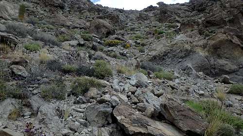 Eventually you will be able to climb up this steep gully.
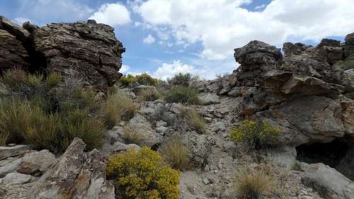 At the top of the gully you will reach this, the "portal"...it is at N 37 28 02.3, W 117 22 33.9 Pass through and you'll now be on the edge of the summit plateau, with the view shown in the next photo.
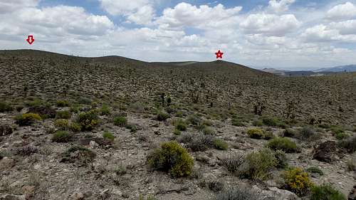 View from the portal; The red arrow points to the true high point (6,412'), where there is a cairn and as of May 2016, a register. The red star marks another high point (6,396') which is where the survey benchmark is.
Overview
Mount Jackson (6,412') near Gold Point, Nevada (Esmeralda County) is in Andy Zdon's "Desert Summits" guidebook. He does describe a route but the descriptiion is fairly vague. In particular, the driving directions are not fully correct (or I'm just reading them wrong). Beyond that, I'm not sure I actually followed the climbing route he describes. I picked this route out by driving around the mountain and looking for the way I could get up and down with the least trouble!
This route did work and is not too tough. However it's definitely a difficult class 2 and you might find yourself on some terrain that is arguably class 3. Plus of course there is no trail. So climb at your own risk!
I've provided some coordinates, but I think between the description and the illustrations you can find your way without them.
At the time I climbed this, there didn't seem to be any online reports for this peak. So as a public service I created this. :) There are now some other online reports. But they all used different routes. So I will leave my route here as an alternative.
Getting There
The turnoff from Highway 266 is about 14.5 miles west of Highway 95, at approximately 37.443889, -117.417778 (WGS 84). Drive about 1.8 mile northeast on this graded dirt road to a smaller dirt road on the right. Turn and drive a little ways south/southeast on this road then park.
I parked at about 37.461944, -117.397222. In this area I didn't see any turnouts or anything that would be a good parking place. So I just picked the spot with the least vegetation and parked off the road there. As I recall, this involved driving up over a small berm. Due to this alone, I wouldn't recommend a passenger car for this outing.
Route
First hike across the desert and then uphill to a big boulder. Specifically, you can aim for a particular wash and then follow that wash up to the boulder...here are some coordinates to aim for:
Wash Entrance/exit: 37.463889, -117.380556
Boulder: 37.465, -117.378333
The wash is not so important because the terrain is not difficult. In fact during my ascent I didn't use it, I just went cross-country straight to the boulder. However on my descent I followed that wash down from the boulder.
From the boulder, head up toward your next target which is the gap in the gray rock band. At first you can walk up a sort of rock slab (watch for loose sand and rocks). As you continue toward the gap, the slope steepens and you gradually find yourself on loose material. Keep chugging up to and through this gap. The coordinates for the gap are: 37.466111, -117.376944
Continue up but start going left along the base of the cliffs. Eventually you will be able to climb up a steep gully. Climb up the gully and you will reach an opening in the top cliff band. I'll call it the portal. This portal is at 37.467222, -117.376083
Pass through the portal and you'll now be on the edge of the summit plateau. From here you can see the true high point (6,412') to the north; there is a cairn and as of May 2016, a register. To the NNE you can see the another high point (6,396') which is where the survey benchmark is.
Before heading for either of those high points, make sure you'll be able to re-locate the spot (the portal) where you came up, so you can descend via the same route. With all the cliff bands around this mountain you might not want to experiment on the descent.
Zdon's estimate of three miles round trip and about 1,200' total elevation gain is about right.
Red Tape
Far as I know, this is all BLM land in this area. There are no known permit requirements or anything like that. Of course, don't drive off the existing open roads. When parking, stay close to the road and minimize tracks and vegetation damage.
When to Climb
I'd recommend Spring or Fall.
Camping
Dispersed primitive camping is available in the area. You can also camp or reserve other accomodations over at Gold Point "ghost town", which is the nearest settlement. Note there are generally no other services available in Gold Point. http://www.goldpointghosttown.com/
External Links
Trip reports for different routes on the mountain:
Bob Burd's 2015 trip report, including map and GPX file: Click here
Mihai Giurgiulescu's 2020 trip report, including map and GPX file: Click here