
|
|
Mountain/Rock |
|---|---|
|
|
36.40300°N / 81.463°W |
|
|
Hiking |
|
|
Spring, Summer, Fall, Winter |
|
|
4683 ft / 1427 m |
|
|
Overview
 Summit
Unlike many other state parks, Mount Jefferson never had much in the way of infrastructure. There was only the auto road to the summit, a picnic area, two overlooks, and bathroom facilities. This was the nature of the park in 1956, and it largely remains in that form today. At only 564 acres, it’s not a very large park by most measures. Today, it’s principle value lies in the fact that it’s largely an intact forest type on relatively high elevation ridgelines. Oaks and black locust dominate the forest and their twisted trunks make for an interesting sight as you hike among them.
 Mount Jefferson
Recently, the state has moved away from the term “park” for this property, and it’s now officially listed as “Mount Jefferson State Natural Area”. There is no camping within the borders of the park, and there is only a single loop trail along the ridgeline, totaling 1.1 miles in length. The summit of Mount Jefferson is cluttered with a communications tower, formerly a fire tower modified for its present use. There is only a small viewing area from a rocky section at the top.
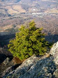
Mount Jefferson also has a secondary peak called Luther Rocks, which is far more impressive a feature than the summit proper. From this section you have 360 degree views from the bare amphibolite outcroppings of the top of the mountain, the valleys far below, and the ridges stretching off to the horizon. One is also aware from these vantage points how fragile this part of North Carolina has become and how much of a great threat it is under from the constant pressures of development and urban sprawl. The foot of the mountain that touches the town of West Jefferson is a running sore of a place featuring car dealerships, big box superstores, a trailer park, spreading subdivisions, and open construction sites. From the summit there is the constant drum of automobile engines and construction equipment.
 Hemlock
As an example of a rare hardwood forest and another of the exposed high peaks of amphibolite, Mount Jefferson makes for an interesting side trip. However, don’t head there expecting anything like isolation or a place to get away from it all. Unfortunately, “it all” lies far too close at the base of the mountain.
Getting There
From I-77 take 421 North to 221 North to 88 West. In the town of West Jefferson, look for the sign to Mount Jefferson State Natural Area for the paved auto road to the park. Summit view.
Red Tape
 Trail
TrailCamping
No camping.External Links
 Luther Rocks.
NC Office of Environmental Education.
The Official Mount Jefferson State Natural Area Website.