
-
 16430 Hits
-
 83.69% Score
-
 17 Votes
|
|
Mountain/Rock |
|---|---|
|
|
39.66730°N / 105.4563°W |
|
|
Clear Creek |
|
|
Hiking |
|
|
Spring, Summer, Fall, Winter |
|
|
10301 ft / 3140 m |
|
|
Overview
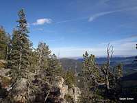
 Hicks Mountain to the South
Mount Judge is a mellow, wooded peak located just off the Squaw Pass Road. While the southeastern slopes feature some neat rocky outcrops, most of the mountain is gentle and rounded. There are no views from the indistinct, forested summit, but by stepping a bit eastward of the summit, one can enjoy views to the east and south, including a nice rambling vista of nearby Hicks Mountain.
This mountain is a nice option to save for winter; Squaw Pass Road typically remains plowed well past this point, and the short distance to the summit from the road make this peak almost a bit too easy in snow-free conditions. The mountain also would combine nicely with nearby peaks such as Hicks Mountain, Mount Pence and Snyder Mountain, but be mindful of private land holdings in the area.
Rank: 2131st highest peak in Colorado
Prominence: 521 feet
USGS Quad: Squaw Pass
Planning Map: Trails Illustrated #104 Idaho Springs | Georgetown | Loveland Pass
Rank & Prominence: Lists of John
Getting There & Route Information
 Lela the hiking dawg
 Hiking the northeast slopes
 Sante Fe Mountain from parking
 Wide area in trees, NE slopes
Mount Judge resides about 25 miles west-southwest of the center of Denver, Colorado. The easiest access to the peak is from Hwy 103 (Squaw Pass Road).
Driving from Denver
• Follow I-70 west to Exit #252, which is CO 74 (Evergreen Parkway).
• Take Evergreen Parkway for roughly 3 miles to Hwy 103 (Squaw Pass Road).
• Turn right on Squaw Pass Road.
• Follow Squaw Pass Road westbound for about 7-ish miles to the intersection with Clear Creek County Highway 475. Parking is on the right/north side of the road.
Routes to the Summit:
Northeastern Slopes: The summit of Mount Judge is approximately 1 mile away from the road (Hwy 103). Within that mile, you’ll gain a healthy 1,115 feet on the northeast slopes of the peak. Be sure to avoid private property holdings between the road and the summit, including apparently some leased State Lands.
Southern Ridge: Alternately, from the parking area, head southbound along an old roadbed (heading right down the old roadbed, not left down the active county road). The route cruises through the trees around the eastern slopes of Mount Judge (10,301 feet). Head southwest into a hollow, then steeply gain the south ridge of Mount Judge.
Red Tape
 Red tape, property boundaries
| This area is a strange patchwork of National Forest lands, Denver Mountain Parks land and private property. Certain paths and old roadways, however, seem to be respected recreational rights-of-way. Please help ensure future access to these trails by behaving yourself. There is no fee visit this area and permits are not required for parking or foot travel. Please follow LNT (Leave No Trace) principles: 1. Plan Ahead and Prepare 2. Travel and Camp on Durable Surfaces 3. Dispose of Waste Properly 4. Leave What You Find 5. Minimize Campfire Impacts 6. Respect Wildlife 7. Be Considerate of Other Visitors |
Camping & Lodging
 Hicks Mountain
 Mount Pence and Snyder Mountain
Echo Lake Campground
The Echo Lake campground is less than ten miles from Mount Judge via CO Hwy 103. It is a small, relatively high elevation campground at 10,600 feet elevation with only 18 sites and is open seasonally from (roughly) late May through mid-September.
Georgetown
The community of Georgetown has a few lodging options, mostly of the simple, family-run variety. Visit the Trip Advisor Georgetown Page for more information on lodging in this town.
Idaho Springs
Like Georgetown, nearby Idaho Springs has a few simple, family-run lodging options. Visit the Trip Advisor Idaho Springs Page for more information on lodging in this town.
Weather & Seasons
 From an eastern outcrop
 Hicks Mountain framed
  Click for weather forecast | Mount Judge is a year-round peak and in fact winter is the ideal time to visit. Heavy snows in winter and spring could result in temporary closure of Hwy 103. Expect very dense crowds along the Hwy 103 / Hwy 5 corridor in the summer. |  Click for weather forecast |
hgrapid - Nov 1, 2012 12:16 pm - Hasn't voted
latitude - longitude39.667108, -105.456235
Sarah Simon - Nov 1, 2012 1:24 pm - Hasn't voted
Re: latitude - longitudeThanks. The system killed the page entry 2 times last night...I guess the 3rd time I built the page, I forgot to enter the coords. Sara