
Comments
No comments posted yet.
|
|
Trip Report |
|---|---|
|
|
48.85554°N / 113.95529°W |
|
|
Download GPX » View Route on Map |
|
|
Jul 30, 2014 |
|
|
Mountaineering |
|
|
Summer |
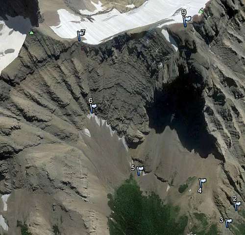
From the Mokowanis Campground it was 7.2 mile round trip and 5044 feet of elevation gain. The route up was only about 50 feet from the last camp site up a wash to a coulee. This wash is covered in thimble berry bushes in late July, you see the gravel from the wash. The bushes are below the waist. You have a very lite bushwhack through these bushes for about 300 yards and continue up the coulee to the tree/bush line on the side of the mountain (You gain about 1000 feet in elevation). When your at about the top of this line turn left at about the 6057 foot elevation point and cross over to the next coulee which is wpt 3. Proceed to the top until you see the bowl at the foot of Mount Merritt at wpt 4. When your at Wpt 4proceed down the slopes belowthe cliffs to Wpt 6.It is important that you get the right drainage up to the saddle. If you miss it, you still can get to the saddle, you just have more class 4 to deal with. I would put this wpt in your GPS. I missed it on the first try using Gordon book. Once your on the saddle it is very clear which one is the right one. Climb to the saddle is over 1200 feet of elevation gain through class 3 and some 4. We did observe several areas of bear scat and track with no bear sightings.
•Wpt 1 48-52.579 N, 113-48.645 W
•Wpt 2 48-52.605 N, 113-48.115 W
•Wpt 3 48-52.697 N, 113-48.145 W
•Wpt 4 48-52.659 N, 113-47.834 W