Page Type Page Type: Mountain/Rock
Location Lat/Lon: 34.00204°N / 111.48696°W
Activities Activities: Hiking
Seasons Season: Spring, Summer, Fall, Winter
Additional Information Elevation: 7030 ft / 2143 m
Sign the Climber's Log

Overview

The Mazatzal Mountains are a rugged range of peaks east of Phoenix, with about a dozen peaks over 7,000'. Summiting these various peaks offers a wide range of difficulty, from practically driving to the summit of Mount Ord, to a challenging class IV traverse of the Four Peaks (also the namesake of an excellent Phoenix Brewery). Mount Peeley falls somewhere in the middle, with a maintained trail within a few hundred feet of the summit, follow by a short bit of cross country travel. It is also featured in the popular "60 Hikes in 60 Miles of Phoenix" book.
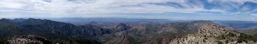
Unnamed Image

Getting There

Getting there requires high clearance, or a general disregard for a low clearance vehicle. 
From Phoenix takes Highway 87 towards Payson, and turn left onto Sycamore Canyon after mile marker 222. Drive 1.2 miles on this paved road to FR 25 and turn right onto the dirt road. Follow this another 1.2 miles to FR 201. At this point the road worsens, with intermittent stretches of loose rock and ruts. The road is unfortunately just wide enough for one car in many places, and it can be really difficult to find places to pull off if you run into another vehicle. Take this all the way to the end, a bit over 8 miles in total.

Route

Unnamed Image
Trailhead
The route starts along the Cornucopia Trail, which was recently renamed the Mt. Peeley trail based on the new sign at the trailhead. This weaves around some small bumps along the saddle with Mount Peeley until reaching the well signed junction with the Arizona Trail, running from Mexico to Utah. Hook right towards Utah and the trail begins switchbacking up the east slopes. There's a nice bench about halfway up facing south. Shortly after the bench, the trail makes an ascending traverse around to the north side of the mountain and enters a pine forest, which was for the most part spared by the Willow Fire of 2004. After a few more short switchbacks, the trail runs fairly straight along the north slopes with minimal incline. After about .25 miles, the trail hits the Mazatzal Wilderness Boundary with a newly replaced sign. Another 100 yards past this is the high point of this section of trail and a large cairn marking a use trail to head up toward the summit. The use trail is pretty easy to lose with cairns taking you in and out of bushes, but as long as you're ascending, you're heading in the right direction. There's a few small false summits before topping out on the broad, treeless summit with great views of the rest of Tonto National Forest and the Phoenix area. A benchmark is located in the lower north rock pile, with a summit register in the higher southern rock pile.

Red Tape

No permits needed. This area can be popular with hunters in the fall and OHV enthusiasts year round, so plan accordingly. The higher elevation sections of the road can see some dustings of snow in the winter, although I don't think the roads are ever closed.

When to Climb

Fall and Spring are best, but can be done year round. Summers will be hot and afternoon thunderstorms could make the road a bit sketchy. Winter can bring snow and ice on the upper parts of the route.

Camping

At large camping is available throughout the National Forest, including dozens of places along the drive in and the trailhead itself. Nearest facilities are probably Theodore Roosevelt Marina, followed by the numerous options in Payson or Phoenix.

External Links

My trip report: http://themtsarecalling.com/peeley/