
-
 21122 Hits
-
 85.87% Score
-
 21 Votes
|
|
Mountain/Rock |
|---|---|
|
|
51.27142°N / 124.5684°W |
|
|
Mountaineering, Trad Climbing, Ice Climbing |
|
|
Summer |
|
|
10820 ft / 3298 m |
|
|
Overview
Mt. Queen Bess is a staggeringly beautiful mountain that towers over its neighbors just north of the vast Homathko Icefield. The mountain is exceedingly remote and, due to its proximity to the relatively popular Mt. Waddington, receives a mere handful of visitors per year. The peak derives its name from Queen Elizabeth I of England and is the 12th most prominent peak in British Columbia. Mt. Queen Bess provides many options for excellent climbing in a true wilderness setting. Steep on all sides and covered in loose rock, ice and 60 degree snow slopes, climbing this mountain is quite an undertaking. Mt. Queen Bess
Getting There
Mt. Queen Bess is extremely remote and inaccessible, being over 100 miles from a paved road in any direction. Most people who attempt the peak probably fly onto the glacier at the base of the peak via helicopter. For everyone else who either cannot afford a helicopter ride, or for those who are seeking a little more adventure:1. Starting at the Nu Chugh Beniz Campground on the eastern shore of Chilko Lake, you can either canoe or hire a boat to take you across the lake to the far end of the Franklin Arm on the western shore. You will then embark on an epic two day bushwhack up Nine Mile Creek until you reach the toe of Alph Glacier, at which point there is an additional two days of trekking across the icefield to the base of the mountain.
Nu Chugh Beniz Campground is in the heart of the Tsil-os Provincial Park and on the eastern shore of Chilko Lake, the largest high-elevation natural freshwater lake in the world! The campground can be reached by car, but is a 10+ hour drive from Vancouver, including over 120 km of dirt roads.
About the park (from the park website): "Ts'il?os Provincial Park is located in a relatively undeveloped and isolated part of the Chilcotin. As the crow flies, the park is approximately 160 km southwest of Williams Lake, or 250 km north of Vancouver. There are two main vehicle access routes into the park, and two campgrounds, one at the end of each route. Both routes take 4 - 6 hours from Williams Lake, though travel time varies considerably depending on weather conditions. Roads are rough, and conditions vary considerably. Drive carefully and with lights on. The nearest communities to the park are Nemiah Valley, Hanceville, Tatla Lake and Williams Lake. "
Directions and information about the Nu Chugh Beniz Campground: This very scenic but often windy campground on the east side of Chilko Lake is accessed via Highway 20 to Hanceville, then 121 km on gravel from Hanceville via Konni Lake and the Nemiah Valley. Supplies are available near the campground at the Nemiah Valley Tl'ebayi Community Centre: gas, propane, laundry and internet service. This campground runs on a self registration system and drop boxes are in place so people can pay their overnight fee. There are no payphones at this campground. There is a camping fee of $11.00 per party per night.
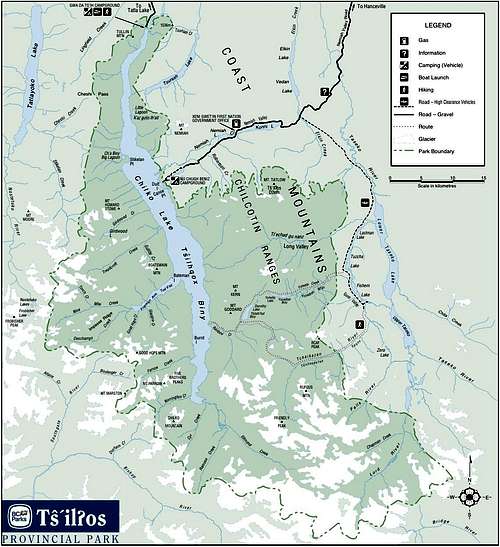 Map of Chilko Lake and Tsil-os Provincial Park
Once you've been dropped off at the terminus of the Franklin arm, use Nine Mile creek as a handrail until you reach it's source--a steep cirque. Climb up onto the ridge and descend towards the Alph Glacier. Ascend the Alph Glacier heading West, then veer North West onto the Queen Bess Glacier. After traversing the Queen Bess Galcier for about three miles, you will veer North towards a pair of unnamed lakes, at which point you will have to navigate a series of steep ridges and valleys in order to penetrate into the Queen Bess complex. A detailed overview of the route is provided in the map below (the route includes a divergence to a great base camp location on the South ridge of Mt. Queen Bess).
 Approach to Mt. Queen Bess from the Franklin Arm of Chilko Lake. Note: This map is composed of three 1:50000 quads stitched together. One of the maps is in meters, while the other two are in feet. The metric map has contour intervals of 40 meters, the imperial maps have contour intervals of 100 feet.
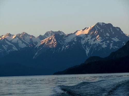 The coast ranges loom above the shores of Chilko Lake, en route to the Franklin Arm.
 View of Nine Mile Creek looking east.
2. Hire a float plane to fly you from Campbell River on Vancouver Island to the head of Bute Inlet where you will be dropped off at a remote logging camp. From there you will embark upon an even more difficult three day bushwhack up steep terrain to the edge of the Homathko Glacier. Once you are up on the ice, you must travel for an additional 25 miles across heavily glaciated terrain to the foot of Mt. Queen Bess.
There are many different options for float plane access to the Coast Ranges, but Vancouver Island Air (www.vancouverislandair) seems to provide some of the better rates and has a good reputation.
You will fly along the picturesque Bute Inlet and be dropped of at the mouth of the Homathko River at the Homathko Logging Camp. From there you will be able to follow some old logging roads east towards Galleon Creek, but soon the underbrush will obscure the road completely, and you will face an intense three day Bushwhack on steep terrain as you attempt to approach the toe of the Bute Glacier.
 The Homathko Logging Camp
Information on Bute Inlet From vancouverisland.com: "The remote and pristine Bute Inlet is a deep fjord located amongst the narrow tidal passages at the northern end of the Strait of Georgia. Carved deep into the mountains of mainland British Columbia's west coast, the wilderness and mist-shrouded inlet boasts magnificent coastal scenery and abundant wildlife.
Considered one of the grandest fjords in the world, the inlet is surrounded by the rugged coastal mountains that heave out of the emerald waters and rise to heights of nearly 10,000 feet, capped by the Homathko Icefield and numerous other glaciers in the surrounding mountain ranges."
A detailed overview of the route is provided in the map below:
 Note: This map is composed of four 1:50000 quads stitched together. One of the maps is in meters, while the other two are in feet. The metric map has contour intervals of 40 meters, the imperial maps have contour intervals of 100 feet.
Despite the difficulty of access, this mountain is truly worth the effort!
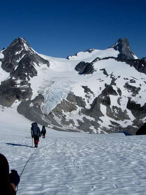 Approaching Queen Bess from the south.
Climbing Mt. Queen Bess
North Ridge RouteThere are no easy routes to the top of Mt. Queen Bess. The least technically challenging route involves climbing the north ridge. This "easy" route consists of climbing lower 5th class loose rock on an extremely exposed knife edge ridge with drops well over 3,000 vertical feet on either side. The north ridge route gives a fantastic view of the unclimbed northeast face and its spectacular overhanging serac.
From a base camp established on the south ridge, contour around the mountain to the saddle at the base of the north ridge, between Queen Bess and Mount Essex. From there it is 1 mile and 2500 vertical feet to the summit. The ridge is extremely exposed and composed of loose and rotten granite. Make sure to bring a wide selection of cams and nuts because the rock is so unreliable that it is prudent to place LOTS of protection to add redundancy (this is somewhat dependent on your tolerance of exposure).
 An overview of the North Ridge Route, from a base-camp on the South Ridge.
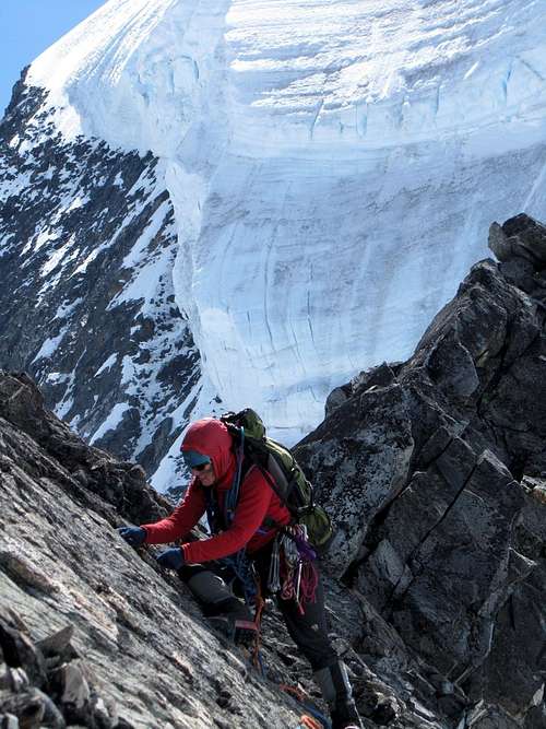 Placing pro on the north ridge of Queen Bess.
 A view of the serac from the north ridge.
 Another view of the serac
Other routes such as the southwest ridge involve high 5th class multi-pitch rock climbing and require considerable skill with rock protection.
Camping
There are excellent camping opportunities in the saddle of the southeast ridge as well as on the Mantle Glacier to the northwest of the mountain. There is great camping located in the clearly visible saddle in the center of the image. Approaching Mt. Queen Bess from the SouthWest.
Red Tape
There is an $11 per party per night camping fee at the Nu Chugh Beniz Campground on the eastern shore of Chilko Lake.The Homathko Icefield is a wilderness area and thus no permits are required to climb or hike on the glacier.
External Links
Mount Queen Bess - WikipediaMount Queen Bess - Bivouac.com
Vancouver Island Air