
-
 26929 Hits
-
 83.69% Score
-
 17 Votes
|
|
Mountain/Rock |
|---|---|
|
|
47.46980°N / 121.4771°W |
|
|
King |
|
|
Scrambling |
|
|
Spring, Summer, Fall |
|
|
5835 ft / 1779 m |
|
|
Overview
 Chair Peak above Snow Lake
Getting There
 Trail to Gem Lake
 Start of Gully to Summit
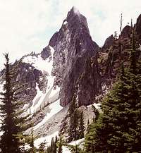 Kaleetan Peak from Snow Basin
 TOPO! software image.
Hike the Snow Lake Trail 2.6 miles to Snow Lake, then follow the trail to Gem Lake around the north side of Snow Lake. This trail will take you to Gem Lake in another 2 miles. From the west side of Gem Lake, find the climber's booth path which follows a ridge to approach Mt. Roosevelt from the northeast.
Once directly under the North Peak, continue south, skirting to the left of buttresses , and arrive in a high snow basin on the SE side of the South Peak. Be sure to climb the higher South Peak (on the left) rather than the lower North peak, which is an easier scramble.
From the basin, a diagonal ramp will lead into the SE gully. Climb the gully to the top. This will be the "crux" of the climb. At the top of the gully, scramble right on easy terrain to just below the summit, then climb an easy but exposed pitch (10 feet) to the summit.
This scramble is 12 miles round trip from the car, with about 3,500 feet of elevation gain. The overall scramble is actually more difficult than the numbers indicate, as the mile going around Snow Lake involves a lot of ups and downs, and the final gully requires care, especially on the way down. One slip and there is no way to stop yourself. Ice axes may be useful to self-belay on the steep heather and dirt.
Red Tape
 Summit Photo
 Chair Peak from Summit
The road is open year round, as it also serves the Alpental Ski Area. However, there is EXTREME avalanche danger on this trail, not to mention frequent artillery barrages from the ski area in the winter.
When To Climb
The mountain is generally climbed May through October. Due to extreme avalanche conditions and artillery bombardment from the Alpental Ski Area, it is highly advisable to avoid this area in the winter/early spring months.Camping
 Chair Peak from Summit Gully
 Snow Lake from Summit
Mountain Conditions
The closest year-round Forest Service ranger station is in North Bend, about 14 miles from Snoqualmie Pass. Contact information:North Bend Office
42404 SE N. Bend Way
North Bend, WA 98045
(425) 888-1421
Snow conditions are available from the Summit at Snoqualmie Ski Areas (of which Alpental is one) at the following website:
Summit at Snoqualmie Snow Conditions
Also, webcams are available from the Washington State Department of Transportation at:
Snoqualmie Pass Web Cam