
-
 6384 Hits
-
 74.01% Score
-
 4 Votes
|
|
Mountain/Rock |
|---|---|
|
|
45.88305°N / 122.05639°W |
|
|
Skamania |
|
|
Hiking |
|
|
Spring, Summer, Fall |
|
|
4535 ft / 1382 m |
|
|
Overview

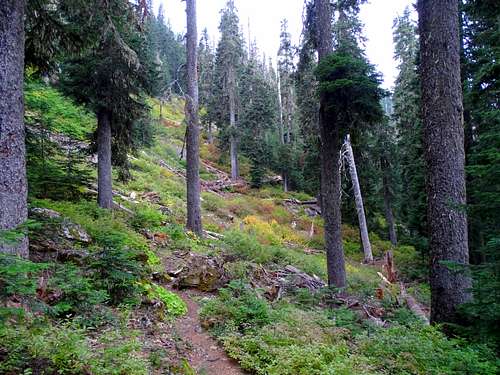
Don't you hate it when a peak doesn't have a specific name? In the same vein as Hidden Lake Peaks and The Twins, I present to you Soda Peaks. I can understand it a little bit because this is not a very big mountain and the summits are not far apart. But it would have been better had this just been named Soda Peak and people would have known to go to the higher one to claim the summit. Sadly, it was not and we have to live with it. The two summits are distinct, like cat's ears if one ear was slightly folded or maybe bitten off by another cat. Both summits are forested with the west summit the higher of the two.
The draw to this peak is not the summits though. The reason why this is a popular hike is the lake nestled between and beneath the summits .... drumroll.... Soda Peaks Lake! With its proximity to Portland and the well-maintained easy hike to the lake, this area sees a lot of visitors. About 3000 parties each year according to Wilderness Permit records. So don't expect solitude unless the weather is bad and don't plan on skinny-dipping unless you are not shy. The lake is pretty shallow and is a great swimming hole. It's stocked yearly with eastern brook and brown trout as well and you will see them popping up and down out of the water feeding. Just know as you wade into the shallow waters, you are walking in the crater of a volcano that erupted about 360,000 years ago.
Since this is not a website about lake-visiting, you will want to know that this peak sits within the Trapper Creek Wilderness, a small Wilderness Area about halfway between Mounts Hood and St. Helens. This lies within the Gifford Pinchot National Forest. There are views of St. Helens along the trail up from Road 54 but that's about it.
There are 3 possible ways to scale Soda Peaks. The easiest and most popular is from the west on Soda Peaks Trail 133 from Forest Road 54 and is only about 1.15 miles to the summit with 825 feet of elevation gain. If you want more of a workout, you can also access it via the Trapper Creek Wilderness Trailhead from the east which would be more of a workout with about a 5 mile hike to the summit gaining 3500 feet. Now, I know I said there were three ways and technically there are but the shorter route from the east via Government Mineral Springs has officially been decommissioned and abandoned, a fact I wish I would have known before I took a girl and two dogs along with me on that trip. The trailhead is hard to find and quickly degenerates to thrashing through a creekbed and occasionally finding parts of an old trail. It meets up with the Trapper Creek Trail eventually before it starts climbing up the mountain but unless you are looking for adventure and confusion, I wouldn't recommend that way any longer. (Although the creek is pretty to walk along in spots if the water is low.)

Wish I could tell you how this peak got its name. The lake is not effervescent. Coke and Pepsi aren't fighting over it. Let's just be thankful it's not another name like Green, Elk or Table. If you are summiting this one though, it's worth the trip down to the lake to hang out and enjoy the waters. It's a serene spot to cool off in the hot summer or enjoy vibrant orange and red vine maples in autumn.
Getting There

If Coming From the South
If coming from the Gorge you will get to the Bridge of the Gods in Cascade Locks and cross the Columbia River ($2 toll each way) to the Washington side. Head east on Highway 14 to (and through) Stevenson, WA. Between 2.6 and 2.7 miles east of Stevenson, turn left on Wind River Road towards (and shortly into) Carson, WA.
If you are doing the shorter hike from the west - go 8.7 miles to Stabler, WA and turn left onto Hemlock Road. About a quarter mile down this road, turn right onto Szydlo Road (also called Road 54) and go 13 miles staying on Road 54 at both signed forks. At mile 13 you will come to an unsigned junction where Road 54 goes left, Road 5407 goes straight and an unnamed spur road on the right goes to an old beaten up forest gate. I would suggest parking before the gate (even though it looks like it couldn't be moved, you never know) as there are spots for about 4 or 5 cars. The trailhead is a little hard to find but it is on the right side of the spur road just before the gate. There is a Wilderness Permit board hidden from the road just a short distance on the trail that lets you know you are on the correct trail.
If you want to do the longer hike from Trapper Creek Wilderness to the east, get to Carson the same way as noted above but then go 14.5 miles on Wind River Road to where it makes a sharp right turn. Instead, go straight at this point onto Mineral Springs Road for another .4 miles to gravel road 5401 for the Trapper Creek Wilderness Trailhead. Follow FR 5401 another half mile to the trailhead. This is a larger parking lot with room for maybe 20 or so cars.
If Coming From the North
At this time (2017), Road 54 is closed about 10 miles past Soda Peaks, so there doesn't seem to be an option for this unless you research a lot of forest roads in your Washington Gazetteer. I would suggest coming down to Highway 14 along the north side of the Columbia River and east to Stevenson and then follow as above.
Routes
Shorter/West Route (Soda Peaks Lake Trail 133)
From the trailhead described above, sign in at the Wilderness Permit station and proceed to climb through a short replanted section with firs about 15 feet high into an older forest, maybe 100 years old with some occasional old growth specimens. The trail heads southeast to pick up the ridge coming down south from the summit. The trail goes up the spine of this ridge for a short distance and then gradually heads off to the right and away from the summit to catch the ridge heading down east from the summit. You have the option of either staying on the south ridge and bushwhacking to the summit, or, staying on the trail until it catches the east ridge (where you come to a sign telling you that you are entering the Trapper Creek Wilderness) and then heading left up that ridge to the summit. The east ridge appears to be a little more open while there is a bit more bushwhacking on the south ridge. You could also go up the south ridge to the summit and down the east ridge to not go back on yourself if your plans call for heading down to the lake. I would suggest continuing on the trail down to the lake though. It will add another couple miles to your trip (but really this is a short easy one either way) and you'll have to come back up the 550 feet down to the lake from the ridge but it's worth it.
Longer/East Route (Trapper Creek Trailhead)
From the parking lot, take Trapper Creek Trail 192 west staying on it past the Dry Creek Trail junction and then later going straight at the Observation Trail junction. You will cross the creek on a couple of footbridges until you come to the junction with Soda Peaks Tie Trail where the old Government Mineral Springs Trail meets. Cross the creek again on a bridge and then head up steeply for about 2 miles to Soda Peaks Lake. Continue past the lake around its west side and then up to the ridge between the two summits (the one you see from the lake is the lower on, you can't see the true summit from the lake). Head right along the trail towards the western summit. Where the trail descends off the ridge to the left, continue on the ridge straight ahead and up to the summit.
Note that the summit is now covered with short Devils Club and shrubs. Fight your foot though it to touch and claim the summit!

Red Tape
No Passes needed at the Soda Peaks Lake Trailhead 133 from Road 54 to the west.A Northwest Forest Pass is required to park at the Trapper Creek Wilderness Trailhead though.
Wilderness Permits are required to be filled out and carried with you though at both.

When to Climb
It's all going to depend on the snow level. The trailhead for the Soda Peaks Lake 133 from the west on Road 54 is at 3670 feet and that is usually free of snow by May or early June. The Trapper Creek Wilderness Trailhead is at about 1140 feet so is accessible most, if not all year. Note though that you will hit snow as you climb at least into May. This area is a little microclimate and seems to get and hold more snow that other nearby areas. Trust me, I've been waist deep in snow in March/April in this area before. Take the snowshoes if early season.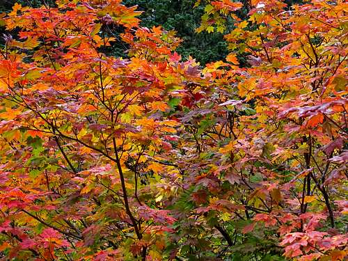
Camping
There are numerous camping sites around Soda Peaks Lake. The main shore in the shallow waters on the north side of the lake are off limits and there is a prominent No Camping sign posted. Please respect this as this area is very popular with hikers and there needs to be at least one area where dayhikers can access the waters too.Mountain Conditions
Mount Adams Ranger DistrictDistrict Ranger: Emily Platt
Phone: (509) 395 3402
NOAA Forecast