

-
 47187 Hits
-
 85.63% Score
-
 23 Votes
|
|
Mountain/Rock |
|---|---|
|
|
39.80445°N / 2.85232°E |
|
|
Hiking, Mountaineering, Scrambling |
|
|
Spring, Summer, Fall, Winter |
|
|
4485 ft / 1367 m |
|
|
Overview
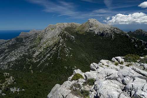 Puig de Massanella seen from Puig des Tossals Verds |
Puig de Massanella or short simply Massanella is the third highest mountain of Mallorca. Like the higher Puig Major (1447m) and Penyal de Migdia (1398m) it is located in Serra de Tramuntana, the mountain range which covers the island's north-western corner. It is considered the island's highest reachable mountain since Puig Major is off limits due to a military zone around its summit, which also covers part of Penyal de Migdia. In most publication this latter summit is considered to be little more than Puig Major's south ridge.
Massanella is a standalone mountain, which stands out some 400m above the low timberline of Serra de Tramuntana. This makes it look much more impressive than its modest elevation, a distinction which holds true for the whole mountain range. Also, reaching its summit along one of its many routes turns out to be more strenuous than expected. Some routes offer considerable exposures wheras the north face scramble is a UIAA II affair.
 |
 |
 |
Any of the routes except the normal one will turn into a full day hike, especially if you do the circle from Lluc Munastery, heading up the south-west face and returning by the normal route. Another long day adventure is the loop from Es Noguer near Embalsement de Cuver, mainly due to the long approaches.
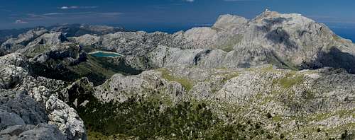 Serra de Tramuntana seen from Massanella
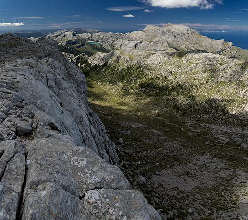
Like the surrounding Serra de Tramuntana, Massanella is a limestone mountain. A sloped karst plateau - the location of the normal route - leads up to the summit from the south-east. It culminates in a number of smaller summits, from which two stand out among the others and which give the mountain the characteristic look. To the north and the west the plateau suddenly stops with faces of 100m - 200m height.
 |
 |
 |
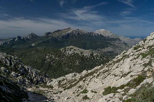
Being a standalone mountain makes Puig de Massanella a wonderful lookout. Moreover it is located almost centrally in Serra de Trammuntana, with the range spreading out beneath its base. On clear days (which are not common) you can see along all of the coasts of the island with the three capes Formentor, Alcudia and Ferrutx in the north and the large fertile plains of the centre and the south. In addition to the more than 40 summits of Tramuntana, which exceed 1000m.
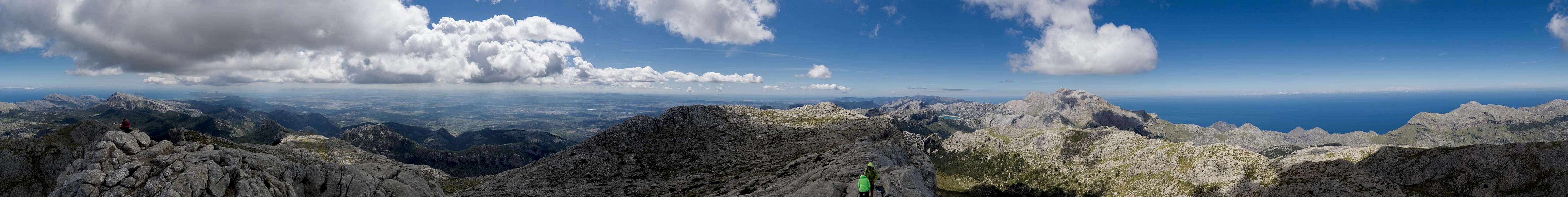
360° Summit Panorama
  |
Routes and Approaches
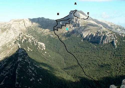 Routes to Massanella - the normal route connects E with A
There are three trailheads, from which you can start your quest to Puig de Massanella, which require different approaches. All but one of them (the normal route) connect at or in the vicinity of the saddle Coll des Prat (1205m). SPer Goldilocks has done a good job to describe them on his route page From Es Noguer
Normal Route
The normal route starts at Coll de Comafreda at around 830m and heads up a dirt road to Finca de Comafreda, where you have to pay a fee to be allowed to proceed. It heads in south-westerly direction until it reaches Coll de sa Linea, where it turns west and runs across the karst slopes towards the summit. There are two big steps to cross. After the first one you reach the karst plateau, where orientation is not straightforward, even though you can see your destination in front of you.
Alternatively you can turn west at Finca Comafreda already, heading up to Coll des Prat for any of the other routes.
Approach from Lluc Monastery
A well marked hiking trail leads west from the parking lot at Lluc through a dense oak forest. It crosses the road MA-10 (also a possible trailhead but very little parking space) and heads out onto a paved sentiero with marvellous views which winds through the north slopes of Puig d'en Gallileu (which you can easily bag en route). Descending a little it joins the alternative route from Finca de Comafreda and heads for Col des Telegraf and Coll des Prat.
Approach from Font d'es Noguer
(Description from Goldilocks):
Leave the car park at Es Noguer and follow the new canaleta eastwards for some 35 minutes. Where a path ascends from the left and a bridge crosses the canaleta cross the bridge and follow the path ascending into woodlands. Soon the col is reached at 825 metres and the path begins to descend. After a few minutes a view appears through trees up the valley (Comellar des Prat) to the Col des Prat with Massanella to the right. The way goes up the right of the Comellar with decision points shortly after exiting the trees and shortly before reaching the Col des Prat.
Once up on a large karst plain the trail leads directly to the mountain, which you can bag
From Coll des Prat there are basically two routes:
Direct Route
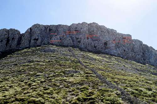 Routes to Topo of the direct route by Oujmik
You head directly for the cliff and scramble up on the left hand side to reach a ledge. From here a ledge system leads to a place on the west ridge, from where you can walk over to the summit.
Alternatively you can climb the chimney directly, which heads up from the base of the wall and reaches the ridge east of the summit
For more information - with more specific details - have a look at this addition
South-west ridge of the secondary summit
South of Coll des Prat a narrow but marked path leads to the base of the Massanella west face. It negotiates the rocks at the base in direction of Puig de ses Bassetes to attain the south-west ridge of the secondary Massanella summit. Here a bit of steep scrambling leads to this summit (1347m) and from there across the summit plateau to the main summit
Alternatively you can descend to Font des Prat from where a marked path leads you to the same secondary summit, avoiding the somewhat exposed south-west ridge.
Getting There
 Puig de n'Ali Puig de Massanella and Puig Major
A typical tourist location, the island Mallorca can be best reached by plane. There are flights from virtually every European international airport to Palma de Mallorca. From the island capital the following itinerary leads to the most common trailheads:
- Take motorway Ma-13 from Palma north-east to Inca.
- Switch to Ma-2130, direction Lluc Monastery
- The first trailhead is at the intersection between Ma-2130 and Ma-10 to Polenca
- The second trailhead is at Lluc Monastery, which you reach from the intersection by following Ma-10 eastwards and later Ma-2140 to the monastery.
To reach the third trailhead at Font des Noguer you have to follow Ma-10 westwards in direction Sòller, passing Embalsement de Gorg Blau. There are two parking lots, one close to the source, one a little later near Embalsement de Cuber
Red Tape
 Puig de Massanella seen while descending Puig des Tossals Verds
The normal route to Massanella runs over the private property of Finca Comafreda. The owner charges a fee, currently €6 per person. Also, if you plan to start from Lluc Monastery for the parking lot you are charged €4.50 per day.
When To Climb
 |
 |
 |
You can climb Massanella all year round, however September through May is the best time. Avoid the hot summer months.
Accommodation
Generallly, there are lot of accommodation options on Mallorca, which you can find on the usual portals. Prices, however, are quite high.
In the vicinity of Massanella there is a campground near Lluc Monastery and a mountain hut, Refugi son Amer close by. The sanctuary itself also provides small rooms ("pilgrim cells") for overnight stay at a moderate price.
Weather Conditions
 Looking across the west face of Massanella towards Puig Major
The right clothing provided, the mountain can be accessed in any weather condition.\
Maps & Books
There are many publications about hiking on Mallorca. I include the ones which I have used myself as well as recommendations by other SPers. The book by Rolf Götz, which is available in four languages has a good choice of routes, two thirds of them in Serra de Tramuntana. Two routes are dedicated to Massanella.
In particular I want to recommend the book by Marc Schichter & Kirsten Elsner, even though it is only available in German. It comes with an excellent map of Serra de Tramuntana (probably the best available) and lots of routes which can be connected at will.
Maps
- Mallorca
4 map box set
Kompass Verlag
1:35000
ISBN: 978-3-99044-062-9 - Walk Mallorca
Discovery Walking Guides
1:40000
ISBN: 978-3-99044-062-9
Books
- Mallorca
Rolf Götz
Rother Verlag
ISBN: 978-3-7633-4805-3 (English)
ISBN: 978-3-7633-4122-1 (German)
ISBN: 978-3-7633-4923-4 (French)
ISBN: 978-3-7633-4701-8 (Spanish) - Wandern auf Mallorca
Marc Schichter & Kirsten Elsner
Reise Know-How
ISBN: 978-3-89662-289-1 - Walking in Mallorca: Classic Mountain Walks in Mallorca
June Parker
Cicerone Press
ISBN: 978-1852844882
FallingUp - Oct 13, 2017 6:11 am - Hasn't voted
North face scrambling route updatesThere is a "grade 2" listed scrambling route up the north face of massanella. in a nutshell, "grade 2" means that this should NOT be attempted by those without a solid degree of competence on rocks, as there are places where a single wrong move could lead to a fatal fall. That said, this route can be done, under dry conditions, without any particular equipment. However, be advised that it would be much harder to go 'down' it than up, so it is in essence a 'one way' route. Anyway, to reach the route, you start at the col which is the high point of the GR221. Walk along the "left side" of the stone wall (while facing massanella). As you climb, you should notice a series of cairns that more or less direct you up a vague semblance of a path up to the massanella face. The scramble begins about 15m left of the wall - you should see at least two prominent cairns here indicating this. To be clear - this scramble should under no circumstances be attempted if the rock is wet unless you have rope or other mountaineering protective equipment. It should also not be attempted by anybody without significant recent scrambling experience. It is not a long scramble by any account, but it can be quite difficulty with no easy 'escape routes'. Anyway, the scramble consists of a few initial easy-ish hands-and-feet type pull-ups interspersed with suprisingly flat and wide traverses to the right. Be careful about going too close to the edge as there is loose rock there and an "over the edge" cant to some of the terrain, but it is not hard. Where it gets the hardest, and this is the key point, is right near the end. Up until this point, you will have been following a series of cairns. I vaguely recall there being a series of red paint flashes there before also showing the way, but i saw no sign of those on my last trip (Oct 2017). You reach a point where there are suddenly no more cairns. And you are looking at the following: 1. on your direct left, something that looks like a crack that might be scramble-able directly. There is some vegetation there. 2. right in front of you, a small step down with a very sheer drop to the right. So, it is very narrow. this might initially fool you into thinking that the route is indeed the crack to the left. actually, it is probably best to go onto the small step down as I think the crack, while certainly climbable at some level, may be the most risky option. if you take the small step down, you now basically have three choices: 1. the leftmost choice which puts you to the left of a large rock. 2. the 'middle' choice which has you climb to the right of it 3. the far right choice which puts you on a ledge which shows considerable signs of wear, possibly from human contact. i recall doing the rightmost choice before, but my memory may be faulty in that. if my memory is correct, it was quite an overhang. of the other two options, the leftmost is probably slightly easier. however, a fall on either could quickly relieve you of your need to pay your mobile phone bill ever again. both require a fairly long reach - short climbers can do amazing things, but if you are much under 5 and a half feet and are not an experienced rock climber it may be very very difficult indeed there. there is however room for a colleague to stand behind you and help you up with an artificial foothold. after you get up this, the remainder to the summit ridge is trivial. so, enjoy the route - but please only attempt it if you really know you can. if any part looks too hard for you, stop, as it only gets harder further up. i strongly discourage anybody from trying to descend this route. its too dangerous. instead, from the massanella peak, follow the ridge towards tossalds verds to where a large cairn indicates the start of a more sensible descent path (about 45 minutes back to where you started from at the col). the actual scramble from the base of the wall is probably no more than 5-10 minutes - a testament to its verticality (and the fact that the walk up to the wall actually gains quite a bit of height).
dtl87 - Apr 11, 2022 2:43 am - Hasn't voted
Re: North face scrambling route updatesWe followed this last week, and it was very helpful, and we wouldn’t have found it without this post. There also appears to be an alternative start 15m to the right of the wall, but it very quickly ends up in the same place as starting to the left. With all the caveats about experience above, I would say that this is slightly more accessible than the post implies. As it traverses, it is not as steep as it first looked, and it less exposed than you’d expect on the first look, and the step down, whilst narrow, is not difficult. I actually did down climb the last part (back to the step down) with no problems to attempt the crack. The crack was more a grade 3 scramble, with perhaps one move that constitutes “climbing”. If you have no experience with scrambling, this is not the place to start, but if you have recent experience and are comfortable with a little bit of hand on rock and a little exposure, then this is entirely doable, and good fun.