
|
|
Mountain/Rock |
|---|---|
|
|
35.16300°N / 83.014°W |
|
|
4040 ft / 1231 m |
|
|
Overview
 View from Little Green Mountain.
Little Green Mountain (so named because Big Green Mountain is just across the valley floor) is a granite pluton that rises up from Panthertown Valley in southwest North Carolina. This area of the state is home to dozens of such granite domes, and Panthertown Valley has quite a collection of this type of peak. Little Green also offers one of the finest views of the Panthertown Valley, which is protected as 7,000 roadless acres of recovering wilderness. This great U-shaped valley has rare high elevation bogs, waterfalls, protected watershed, many rare plants and plant habitats, and is a bear sanctuary. If you're looking for solitude in eastern America, this is one place where you can find it.
An absolutely wonderful website about NC waterfalls in general, and Panthertown Valley in particular can be had here.
 |  |  |
Getting There
From Cashiers: To reach the Cold Moutain Gap Trailhead take US 64 E for 13 miles to where NC 281 turns north (left) at Lake Toxaway. Go 8 miles to Cold Mountain Road (ST 1301) and go 5.8 miles to a very sharp left turn. Follow the turn and go one tenth of a mile to gravel road on right. Take gravel road another tenth of a mile to parking spot at gate.The trails in Panthertown Valley are unblazed and have no signs (save for some unofficial signs at a few trailheads). The best map I have found is the Guide's Guide to Panthertown Valley, which is available from the author at Slickrockexpeditions.com. Get the Map
The route I used to climb the mountain used three trails and a short connector. The loop was, I estimate, about three miles. The climb to the top of Little Green from the floor of the valley was only about 340 feet.
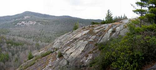
 Panorama
 |  |  |
Red Tape
None.This is a nominal wilderness. Tread carefully. If you venture behind any of the falls, please take care not to trample ferns and other fragile plants. If you hike on the granite domes, stay off of the clumps of lichens and mosses which are also very fragile.
This is prime bear habitat, so take all bear precautions when camping.
 |  |  |
When To Climb
For hiking, all year. For climbing (there are some walls here), I would suggest Fall and Spring.Good information for climbing can be found at this website here
 |  |
Camping
Camping is allowed. Take all usual precautions for bears. Pack it in, pack it out. Camp away from water sources and dig catholes at least 200 feet from nearest water. |  |  |
Mountain Conditions
 Schoolhouse Falls.
Check the conditions at Cashiers and/or Highlands NC. Highlands is likely to be more accurate, as it's closer in elevation to that of Panthertown Valley.
 |  |  |
External Links
- National Forest Panthertown Valley Trail Project.
The official map for the proposed trail project for Panthertown Valley. (As yet uninitiated.)