
|
|
Mountain/Rock |
|---|---|
|
|
64.07040°N / 139.41409°W |
|
|
Spring, Summer, Fall, Winter |
|
|
2911 ft / 887 m |
|
|
Overview
 Midnight Dome and Dawson City, Yukon in 1898
Standing like a sentinel over Dawson City, Midnight Dome has provided the backdrop for one of the craziest migrations in human history...the Klondike Goldrush. Between 1897 and 1899 roughly 50,000 people descended on the area around Dawson City, to stake claims in the Klondike Goldfields. Most of the Stampeders were too late to get in on the gold strikes, but many stuck around at least long enough to earn money for their return trip. Consequently, it has been said that at the height of the gold rush Dawson City was the largest city north of San Francisco and west of Minneapolis. You could buy anything there that could be found in all the great cities of the world, provided you could afford it.
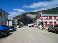
Dawson City today is all about recreating the feel of the gold rush. The city and the surrounding area have many historic sites run by Parcs Canada. You can drive or bike to visit the goldfields just outside of town and even try you hand at panning on Bonanza Creek's Claim #6 which is open to the public.
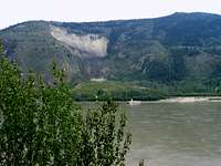
Midnight Dome offers a tremendous vantage point overlooking Dawson City, the Yukon Valley and the Klondike Valley. It gets its name from the fact that the sun barely sets in the summer time as it is located only about
 Midnight Dome and Dawson City, Yukon in 2005
Getting There
 The George Black Ferry provides a connection from both the hostel and the campground to Dawson City and the Midnight Dome Trailhead.
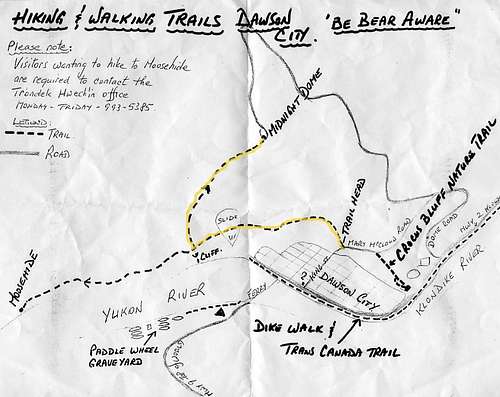
To find the trailhead, follow King St. away from the Yukon River to the edge of town (only about 6 blocks). As you start to walk up the hill, the road bears to the right. The trail leaves the road on the left side and gradually gains elevation for a mile or so as it traverses the hillside until it reaches the large slide visible in the photos (Moosehide Slide). Cross the slide near its base and then continue a short distance to a junction.
Do not go straight through the junction. This leads to the native settlement of Moosehide and is closed to the public (see note under "Red Tape"). Take the trail to the right, which now will climb aggresively up an arm of the main the ridge for another mile or so until it reaches the open summit area. There is a small parking area (you are unlikely to be alone unless you climb early) and magnificent 360 degree views.
 View of Dawson City from the summit
The total elevation gain is 1700 feet and the round trip distance is somewhere in the neighborhood of 5 miles depending on your starting point.
Upon your return, be sure to stop into the Downtown Hotel, sidle up to the bar, and ask for a Sourtoe Cocktail. Round out your day with a visit to Diamond Tooth Gertie's where you can have a great time watching the Can Can Dancers while losing your shirt at the roulette table.
 One man's misfortune (frostbite) is another man's gain...The Sourtoe Cocktail
 Be sure to stop in at Diamond Tooth Gertie's!
Red Tape
There are no access issues or permits required for the standard hike up Midnight Dome. However, you should be aware that just past the slide their is a trail junction with the right fork leading up to the summit. The left fork goes back down to the community of Moosehide, which is part of the Trondek Hwech'in First Nation. Permission is required in order to use this stretch of trail or visit the community. The Trondek Hwech'in office can be reached at 993-5385.For a current map and trail conditions, check in at the Parks Canada Visitor Center on Front St. in Dawson City.
Camping
A ferry provides 24 hour service across the Yukon River where there is a Territorial Campground and the Dawson City River Hostel. The campground is to the right when you get off the ferry. To get to the hostel, take the path through the woods to the left. The hostel allows camping and has some nice covered cooking/eating areas as well as wood heated water for bathing.External Links
Richard D. Huseth's Midnight Dome Photos.Dawson River Hostel