
-
 30518 Hits
-
 84.82% Score
-
 19 Votes
|
|
Mountain/Rock |
|---|---|
|
|
49.23933°N / 124.58676°W |
|
|
Hiking, Skiing |
|
|
Spring, Summer, Fall, Winter |
|
|
5302 ft / 1616 m |
|
|
Overview & History
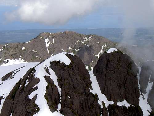 Mt Cokely S aspect from Mt Arrowsmith Mt Cokely S aspect from Mt Arrowsmith |
Poor Mt Cokely! Abused for decades by the logging industry, the site of a defunct ski operation, trespassed upon by mechanised morons and crowned by a radio repeater station. Such appalling treatment of a Vancouver Island icon is hard to imagine. Yet the mountain continues to delight winter and summer visitors alike with its forgiving terrain and superb views of the east coast of the Island, the mainland Coast Range and especially Mt Arrowsmith its higher neighbour to the south.
Situated just east of the head of the Alberni Inlet between the Englishman and Cameron River watersheds, Mt Cokely has long been sacred to the Hupacasath First Nation. Generations of that community have long been accustomed to find peace and spiritual renewal on its slopes.
In 1910, prompted by its success with such ventures in the Rockies, the Canadian Pacific Railway Company built a tourist chalet below Mt Cokely at the east end of Cameron Lake. The company followed this in 1912 with a pack trail and overnight hut in the sub-alpine on the slopes of the mountain which enabled visitors to make ascents of Cokely and Mt Arrowsmith. The CPR trail is still in use today (see “Routes” section below) and remains the oldest contiguous trail on Vancouver Island.
During the next 50 or so years the Arrowsmith Massif, of which Mt Cokely forms the northern limit, grew to become the most popular and well known outdoor recreation resource on Vancouver Island. Thousands of hikers, climbers and skiers visited the area and a volunteer ski operation opened on the north slopes of Mt Cokely. However, the rich timber resources in the valley bottoms below the summits soon attracted the covetous attention of the big lumber companies and when these were exhausted, logging of the higher slopes of the massif was soon underway. Recreational access became an issue, indiscriminate industrial carnage was everywhere and was only made worse by the detritus left by the failed ski operations. Something clearly had to be done.
 Dedication. Crowds gather. Dedication. Crowds gather. |
 Dedication. Speeches. Dedication. Speeches. |
 Dedication. Lunch. Dedication. Lunch. |
 Dedication. New sign. Dedication. New sign. |
For many years Mt Cokely was known somewhat unflatteringly as “The Hump”. In 1973 it was officially renamed for Leroy Sterling Cokely, a Dominion and BC land surveyor.
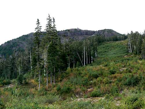 Mt Cokely north aspect
Getting There/Approach
Vancouver Island can be reached by air from Vancouver to Victoria, Nanaimo, Comox or Campbell River and by ferry from Port Angeles to Victoria on The Coho and on BC Ferries from Vancouver to Victoria or Nanaimo. Public transport on the Island is relatively poor and anyone arriving by air would be advised to rent a car. Access in this case requires the use of gravel logging roads. Whilst these are often negotiable in a normal 2WD sedan, some sections are rough and in winter, of course, all bets are off. If you have access to a high-slung 4WD, bring it.From the Island Highway 19 near Qualicum or Parksville, take Highway 4 west towards Port Alberni. Approximately 7.5 km past the Whiskey Creek Save-on-Gas station and just before Cameron Lake comes into view, watch for a wide dirt road on the left. This is the start of the CPR trail.
Drive along the south shore of Cameron Lake, through Cathedral Grove Provincial Park and over the low pass, Alberni Summit. Just west of Alberni Summit watch for a left turn onto gravel and signed “The Connector”. Set your odometer to 0 here. You are on Summit Main. Drive down Summit approximately 2.5 km to its junction with Cameron Main and turn left. Proceed along Cameron until it crosses the Cameron River. 10.5 Km from Highway 4 turn left onto Pass Main at its junction with Cameron Main. The road ascends quite steeply and is much narrower and rougher than the valley main line.
Proceed uphill on Pass Main and at 15.9 km from Highway 4 you reach the top of the last of a series of switchbacks. Beyond the switchbacks is a straightaway that leads to a hairpin bend protected by concrete crash barriers at km 17.8. Park here for access to the Arrowsmith/Cokely Saddle route. This spot is known as “The Cut”
Drive about 500 metres past the Cut to find the trailhead for the Rousseau Chute route on the right.
Proceeding further on Pass Main, about 1 km from the Cut keep right at a road junction. Drive 1 km further to a gate – the old ski area property boundary - and keep right also. Follow the main road as it winds a further 3 km east and then south before coming to an end in a big open area. You can see the old overgrown ski runs above. This is the start of the north approach to the summit.
For progress beyond the above points refer to the following section.
Summit Routes
The CPR Trail
With a 4WD vehicle it’s possible to drive about a km up the old road from Highway 4. Most, however, choose to park by the main road and walk up to the signed trailhead. From this point follow the well-graded switchbacks up the north slopes of Mt Cokely. About a third of the way up the route splits with the “Lookout Trail” to the left and the “CPR Trail” to the right. Many hikers choose to make a loop out of the trip by going up one and coming down the other. Both options lead to the bottom of the old ski hill and from there it’s an easy hike up to the summit – see the North Slopes Route below.The Saddle Route
The first part of this route from the Cut to the saddle is exactly the same as the route to the “Bumps” and “Nose” on Mt Arrowsmith.
 Arrowsmith/Cokely Saddle Arrowsmith/Cokely Saddle |
You are parked at what was spur P37 off Pass Main. In the past this very rough steep road could be driven a further 500m towards the mountain. No more I'm afraid. Walk east up the spur to the beginning of the flagged route up to the saddle between Cokely and Arrowsmith. Not far from the start two sets of flagging appear indicating a split in the route. The rightmost one covers more open bluffy ground with views. That to the left is less steep but is mostly in the forest. The routes converge in a flat section before the last pull up to the saddle.
From the saddle turn left and find a cairned route that weaves its way through the bluffs and northeast to the summit of Mt Cokely.
The Rousseau Chute
A very popular route in winter on skis or snowshoes. Details to follow.The North Slopes Route
From the old ski area walk northeast up the old lift service road on the right of the overgrown ski runs. Beyond the remains of the road, the route reduces to a well-traveled track that turns north and through some minor bluffs before reaching the ridge west of the summit. Walk along the ridge 5 minutes east to the summit and try to ignore its ugly collection of communications paraphernalia.
 North slopes North slopes |
 Hikers on the N slopes Hikers on the N slopes |
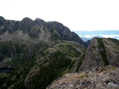
 Mt Cokely summit Mt Cokely summit |
 Emerald Lake Emerald Lake |
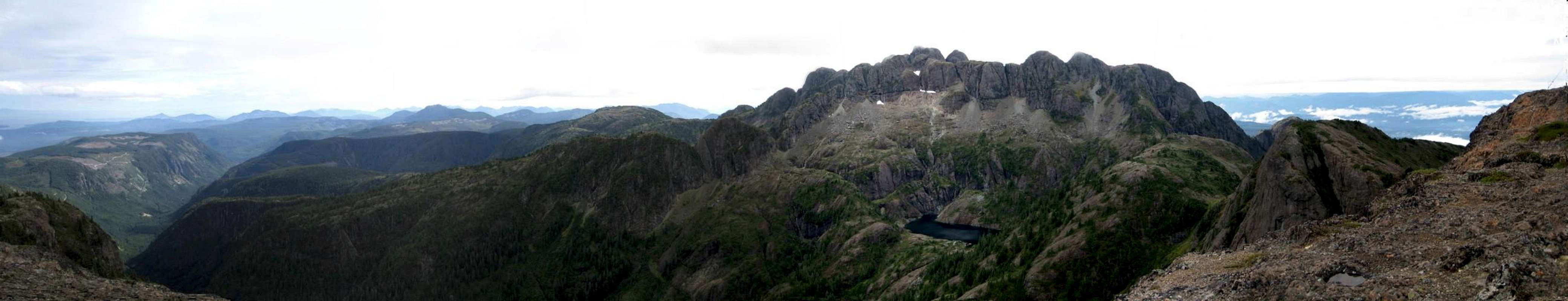
Mt Cokely Summit Panorama
  |
Red tape and Safety Considerations
There are no fees to pay in the new regional park.It’s always prudent to leave a detailed trip plan with someone responsible. The RCMP and the appropriate SAR agency will respond in an emergency but it is up to you to have the mechanism in place that will initiate call out.
There is good cell phone coverage (Rogers) from the summit of Mt Cokely and most spots on the open north slopes.
Camping
There is no restriction on camping that I am aware of. I have seen tents on the Arrowsmith/Cokely Saddle and below it by Emerald Lake. The only limitation would be availability of water. Giardia is well documented, so boil or treat all water. Pack a small stove for cooking and don’t light campfires.Weather
Nearest point current weather and forecast:Additional Information/Suggested Reading
This is a historically important area and first-time visitors will get the most out of their experience by fully immersing themselves in all the mountain’s lore beforehand. In this regard I highly recommend Beyond Nootka – A Historical Perspective of Vancouver Island Mountains, Lindsay Elms, Misthorn Press, 1996, ISBN 0-919537-29-4For more route information and even more routes refer to Island Alpine – A Guide to The Mountains of Strathcona Park and Vancouver Island, Philip Stone, Wild Isle Publications, 2003, ISBN 0-9680766-5-3
For precise directions get hold of a copy of Backroad Mapbook. Volume III: Vancouver Island
For more information on the efforts to achieve official park status for the Arrowsmith massif and an expanded account of the history of the area visit The Mount Arrowsmith website
Illegal Mechanised Incursions on the Arrowsmith Massif
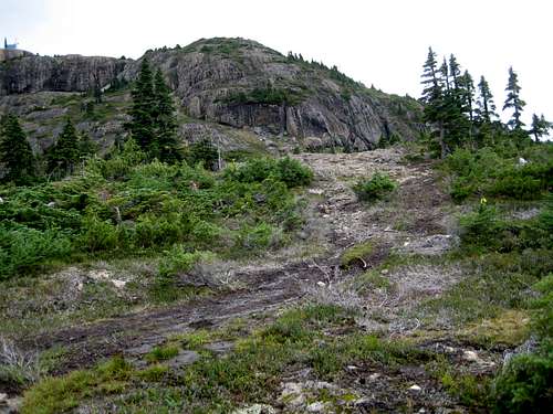 ATV damage on Mt Cokely. Please help us to stop this by reporting violations
The fact that idiots like this simply won’t listen to reason is part and parcel of why the massif was given protected status. Taking a snowmobile, ATV or truck beyond the parking lot at the bottom of the old ski hill or off Pass Main up the Rousseau Chute or anywhere else on the massif is now illegal. Yet it continues. In the near future the Government of BC will implement licensing of ATV’s and snowmobiles. These vehicles will now be readily identifiable to the authorities in the event of illegal use. I urge anyone who witnesses unlawful use of mechanized transport on the massif to do all they can to obtain photographic evidence, report to the RCMP or call 1-877-952-RAPP (7277) to report the license plate numbers of irresponsible operators.