
|
|
Mountain/Rock |
|---|---|
|
|
46.28041°N / 123.34806°W |
|
|
Wahkiakum |
|
|
Hiking |
|
|
Spring, Summer, Fall, Winter |
|
|
1814 ft / 553 m |
|
|
Overview
Crown Point is a low elevation mountain located in Wahkiakum County, Washington. The peak is most popular for logging and hunting, and less for peakbagging. For several years the peak was perhaps most noteworthy to some peakbaggers by being a candidate for the most prominent point in Wahkiakum County. However, on December 4, 2011, Crown Point was determined to not be a contender for most prominent point in the county.
The county's greatest prominence point (CoGPP) is officially recognized as being Elk Mountain, located approximately 10 miles northwest of Crown Point. However, using the "dirty" rules for determining prominence, it was possible, albeit slightly, that Crown Point had a higher amount of prominence than Elk Mountain. Elk Mountain has 825' of clean prominence, whereas Crown Point (which had a summit elevation range rather than defined point) has a saddle contour that provided a range between 760'-840' of prominence.
 Fog-Covered Summit Area
Oddly, topographic maps have shown a 40-foot closed-contour for the summit area, making the summit elevation range between 1800'-1840' elevation. The has seemed peculiar because the summit not only has a definitive and visible highest point, but also an official USGS Benchmark at that location.
 Pole and USGS Benchmark Representing Summit
December 4, 2011: Crown Point, which only had a slim chance of being a CoGPP contender for Wahkiakum County, was removed from the "dirty" list. Ken Russell discovered NAVD88 datum showing an actual summit elevation of 1814' rather than estimated summit elevation range. Despite the NAVD88 datum differing by up to 7' elevation from topographic maps, Edward Earl determined that the previous probability of Crown Point being a CoGPP contender was only 0.12%, and when combined with the NAVD88 datum showing a summit elevation of 1814' Crown Point was eliminated from CoGPP contention altogether. This is because Crown Point's optimistic prominence of 814' would still be less than Elk Mountain's clean prominence of 825'.
Crown Point and the surrounding areas are owned and controlled by Hancock Forest Management. Hancock allows non-motorized public access at Crown Point, and the mountain can be summited any season during the year. During hunting season (Autumn/Winter), when hiking/biking distance is minimal due to more access gates being open, outdoor enthusiasts can possibly combine Crown Point with nearby Huckleberry Ridge (the Wahkiakum County HP) during a single day.
Getting There
FROM CATHLAMET, WA:1) Drive west along Highway 4.
2) After approximately 4-1/2 miles, turn right (north) onto Elochoman Valley Road.
3) After ~3.5 miles, the road forks. Continue on the leftside road.
4) After 5.3 miles from Highway 4, turn left onto Crown Camp Road.
5) After 0.4 miles, turn right onto an unmarked logging road. The road is initially paved, but soon turns to gravel.
6) After 0.1 miles further, a tiny bridge and gate are passed. If the gate is locked, then park alongside the road prior to the bridge and then continue on foot or bike.
7) After 0.3 miles from the gate, the logging road veers left. Another gate represents the entrance to "Miner Road". If the entrance gate is locked, then park alongside the road prior to the bridge and then continue on foot or bike.
 Entrance to "Miner Road"
8) After 3.5 miles from the entrance gate to Miner Road, turn left onto an unmarked side-road. There is a gate located shortly thereafter on the side-road. Park alongside the road, making certain not to block the road or gate access. Continue on foot or bike.
------------
-> Walk by the gate and begin following the main logging road west towards Crown Point.
-> After ~0.4 miles from the parking gate, a rock quarry is passed.
-> After ~1.0 miles from the parking gate, turn right (north) onto "FC-100" road. "FC-100" road initially heads north and then south around Point 1403, before continuing west towards Crown Point.
NOTE: There is an unmapped logging road that heads south from the "FC-100" road junction.
 Turning North Onto "FC-100" Road...
-> After ~4.5 miles from the parking gate, southwest of the Crown Point summit, there are several unmapped logging roads. Sharply turn right (northeast) and uphill up a rocky road towards the Crown Point summit.
-> Reach the summit within 0.5 miles from the southwest junction.
TOTAL ROUNDTRIP HIKING DISTANCE: Approximately 10 miles
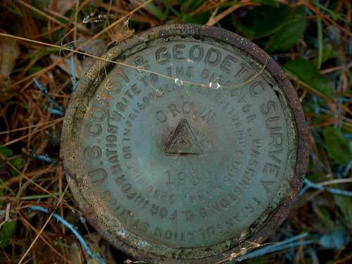 USGS Benchmark
Red Tape
Hancock Forest Management owns and controls the lands and roads at, and near, Crown Point. For current access restrictions, feel free to contact Hancock Forest Management at: 360-795-3653Active logging operations are present throughout the slopes of Crown Point. However, public access is granted. There are several general rules:
1) If planning to reach the summit of Crown Point, public access to some of the roads used on the summit route is only open during weekends, while logging activity is at a minimum (if at all present).
2) Access is only allowed during daylight hours.
3) If any logging machinery, vehicles, and/or personnel are encountered while travelling the Crown Point logging roads, they reserve the "right of way". Unfortunately, because many of the logging roads on the mountain are single-lane, if there is no place to immediately pullout a vehicle on the side of a logging road when logging operations need to pass by, that vehicle will need to back-up to the nearest pullout or side road so that the logging operations' "right of way" is maintained.
Because access to the mountain is controlled by logging operations, public access may be restricted, and/or any of the mountain roads may be made inaccessible, at any time.
Due to the vast amount of logging activity that takes place on the mountain slopes, Crown Point has multiple logging roads present. Some of these roads may or may not show on current topography maps. It is possible that other summit approach routes exist, even if not clearly evident.