
|
|
Mountain/Rock |
|---|---|
|
|
33.54690°N / 113.0786°W |
|
|
Maricopa |
|
|
Hiking, Scrambling |
|
|
Spring, Fall, Winter |
|
|
2917 ft / 889 m |
|
|
Overview
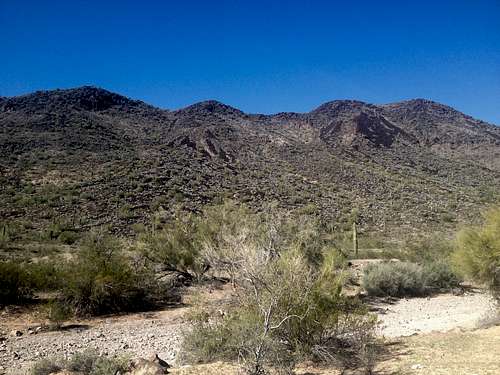
Burnt Mountain is a lonely peak in the Big Horn Mountain Wilderness about 60 miles West of Phoenix near the small town of Tonopah. It sees very little visitation, some years in the summit register were completely without any entry, though it does have 1,397 ft of prominence earning it the 181st spot on the Arizona prominence list. Therefore it should have some interest to people trying to complete certain lists. The wilderness itself does not feature any paved roads, established trails or any other amenities, however the base of the peak can be reached via pretty decent dirt roads. The wilderness is home to the majestic and shy desert big horn sheep and I was forunate enough to see a herd of about 10-12 animals on my ascent.
Burnt Mountain
According to the summit register there only seemed to be acouple of summit visits every year. I was the 2nd person to sign the summit log for 2015 with Gerry Roach being the first! There were only 2 entries for 2014 and none at all for 2013, so solitude is guaranteed.
Getting There
From the Phoenix area, go on Interstate 10 West and take exit 94, 411th Street, which is the Tonopah exit. Go South for a couple of hundred yards and then turn right onto the signed Indian School Road. Zero your odometer here! After 3.9 miles the pavement ends and the road becomes well graded dirt. At 4.9 miles where the road bends around a small but prominent hill turn right onto a smaller, unsigned dirt road; the turn off is right before a "tight turn, 25mph" sign. The first 0.5 miles of this dirt road are the roughest of the entire drive but should still be passable by a passenger car with careful driving. After 6.2 miles the road crosses the Interstate through a small tunnel. Right past the tunnel immediately turn left and then right a 6.4 miles; this is obvious as you are following the main dirt road. Continue on this very well graded dirt road which essentially follows the power lines and cross the CAP canal at 8.7 miles. The directions on Todd's Desert Hiking Guide suggest to turn left at the power lines, however, this road is in much poorer shape than the main track at the power lines and eventually converges with the main road right before the canal bridge. Right after the bridge pass through a cattle gate and then park after another 100 yards on the left side of the road right across from a power line tower; I used the tower as a prominent landmark to aim for on my return across the desert.
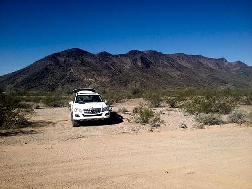
The parking spot with Burnt Mountain in the background
Route
Caution: the entire hike is cross country and involves some scrambling but never exceeds a low class 3
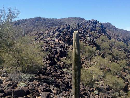
From the parking spot hike across the desert aiming for the low saddle between the 2nd and 3rd bump on the ridge; the elevation at the trailhead is about 1350 ft. There a couple of minor wash crossings on the roughly 0.5 miles flat hike to the base of the mountain. Once at the base of the mountain follow the ravine up to the saddle. On my way up I initially stayed more on the right side of the ravine but then crossed over to the left; on my way down I stayed on the left side (as you look up) and found this to be the better choice. Either way, you need to go up and get to the saddle, where I actually found a cairn when I got there. I did not see any other cairns for the rest of my hike. The elevation at the saddle is about 2250 ft. Once on the saddle turn right and then go up the first and also most sustained scramble section of the climb. Stay on top of the ridge where you will find large and stable boulders; the scramble never exceed a low class 3.

First scramble section of climb
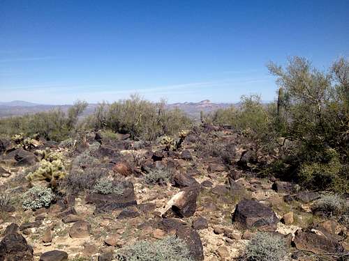
After the first scramble section the ridge levels off somewhat but try to always stay right on top of the ridge where you will find the stable basalt rocks. Resist the urge to drop down or short cut and get around some of the minor bumps along the ridge as this will get you into serious cholla territory. You will encounter one more shorter scramble section before reaching the summit.
Reminder of the ridge to the summit after the first steeper scramble section; the summit is the rounded bump in the center
The actual summit is actually kind of flat and somewhat unspectacular but you get nice 360º views. There is a benchmark and a summit register in a plastic jar under a rock pile.
the summit area
Total round trip distance: ca. 4 miles
Total elevation gain: ca. 1700 ft. (including some ups and downs along the ridge)
Red Tape
No Red Tape as far as I am aware of.When to Climb
This desert peak is best climbed from November through March when temperatures are more moderate. On my climb in mid March temperatures were in the high 80s when I returned to the car. In summer temperatures go up to 110-120F!
Camping
I am not sure if officially allowed but camping at the trailhead should not be a problem. I tried to find information about camping in the Big Horn Mountains Wilderness on their webpage but it does not say anything.
Update 3-18-15: I contacted the BLM office and here is the response I got regarding camping in the Big Horn Wilderness area.
"Yes, camping is permitted in the Big Horn Wilderness area, however you are not allowed to "drive in" the area. You may pull off the side of a road/trail and hike in to camp. Please remember, whatever you pack in, you must pack out."
External Links
Todd's Desert Hiking Guide webpage shows a map of the route which I more or less followed.
Big Horn Mountains Wilderness webpage