
|
|
Mountain/Rock |
|---|---|
|
|
43.39800°N / 71.858°W |
|
|
2937 ft / 895 m |
|
|
Overview
 Mount Kearsarge from the road.
Mount Kearsarge is a dominant peak in central New Hampshire. While not high compared to the White Mountains further north, it has been for generations an attractive peak to hike. Though around 200 feet shorter then Mt. Manadnock and Mt. Cardigan, Mt. Kearsarge has many characteristics of the two. It has multiple trails (though not half the amount of the other two), major popularity and a bare summit (except for the fire tower and the cell phone tower). The three dominate trails on Mt. Kearsarge are the Class 1-2 Wilmot Trail, Class 1 Barlow Trail, and the Class 1 (virtual walk up) Warner Trail. From the summit on a clear day lies a spectacular view of the White Mountains and Mt. Cardigan in the north, the Green Mountains and Mt. Sunapee in the west and the Monadnock Region and the Merrimack Valley in the south.
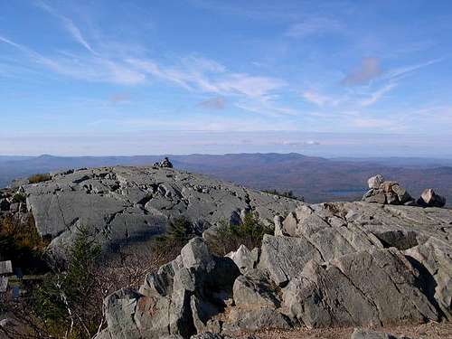 South view from summit
The southern part of the summit is represented by Rollins State Park (fee). It is home to the Warner Trail. The Warner Trail is a very easy virtual walk-up from the auto road which lets out only 0.6 miles and 300 elevation gain from the summit.
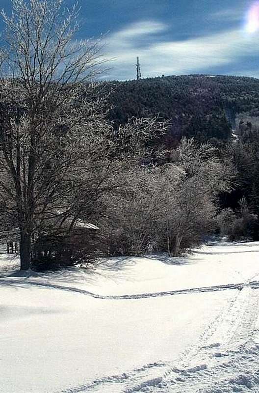
 Pretty hike in winter
On the north side though are the more traditional hiking trails. The trailhead begin in Winslow State Park (fee). The Class 1-2 Wilmot Trail is the older of the two trails and is steep and highly eroded. the newer Class 1 Barlow Trail is gentler trail with a ton more overlooks than its elder.
 |
 |
 |
 |
 |
Getting There
VIA TRAILHEADS AT WINSLOW STATE PARK:From exit 20 off I-93. Take Route 3 west towards Franklin. Go past downtown Tilton and downtown Franklin and make a right on 3A and then an immediate left on Route 11 towards Andover. Go past Andover and stay on Route 11 roughly 4 miles past the Andover. Make a left on Kearsarge Valley then follw signs to Winslow State Park (fee). The trails start at the end of the parking area. In winter the road to the parking area is closed. You have to hike up the road to the parking area.
VIA WARNER TRAIL AT ROLLINS STATE PARK: From Exit 9 on I-89. Head toward the center of the town of Warner (1 mile). Make a right on Kearsarge Mountain Road and follow the signs to Rollins State Park (fee). Once in the park drive up 3.5 miles along Mission Ridge to the trailhead. You will pass many picnic areas. In winter this road is only open for snowmobile use.
 |
 |
 |
Red Tape
There is a substantial fee on both trailheads in summer(similiar to Mt. Manadanock). However in winter the roads are closed (no fee). On the Winslow Side it only adds two miles roundtrip to your hike. But on Rollins State Park side it adds 7.0 miles more unless you have a snowmobile.
 |
When To Climb
Mt. Kearsarge can be climbed at any time of the year. In winter on the Winslow side add 2.0 miles more to your trip due to the road being closed. I would recommend snowshoes on all trails and crampons especially on the Wilmot Trail. I would also advised not going down the WIlmot Trail in winter due to the fact that it is very icy in winter and not half as scenic as the Barlow Trail. On the Rollins side add 7.0 miles unless you have a snowmobile.
In April and May are not recommended for hiking due to mud season. June is good time to hike provided you have bug repellent. Black fly season strikes on this month and you don't want to scratch your way through summer.
 |
 |
 |
 |
 |
Camping
There is no camping allowed on or near Mt. Kearsarge. However there are some nice Bed and Breakfast in nearby Andover, NH.
Mountain Conditions
Contact Rollins State Park at (603) 456-3808 or Winslow State Park at (603)526-6168.
Here are two websites that will provided you the best information on conditions on Mt. Kearsarge.
Appalachian Mountain Club
Current Trail Conditions
Summit Picture Log
Post your summit mugshot here.
External Links
- Rollins State Park
Detailed info about Rollins State Park and Mt. Kearsarge.
EastKing - Feb 16, 2005 6:20 pm - Hasn't voted
Untitled CommentCool winter shots. I might try to hike this mountain from the north side before winter ends. I have hiked this peak many times in spring and summer but never in winter.
Render - Feb 14, 2005 12:38 pm - Hasn't voted
Untitled CommentThe summit road is closed in the winter and maintained as a snowmobile trail by the Kearsarge Trail Snails snowmobile club, and many day hikers make the trip along the groomed snowmobile trail. The peak can be accessed by the narrow and steep foot path although trail conditions are dicey at best for snowmobiles. There is room for about 4 sleds in the glade near the summit, which is usually bare and accessible only by foot. Wind chill on a balmy February day was -30F, but the view of the snow covered countryside in the clear cold air is stunning!
EastKing - Feb 16, 2005 6:20 pm - Hasn't voted
Untitled CommentCool winter shots. I might try to hike this mountain from the north side before winter ends. I have hiked this peak many times in spring and summer but never in winter.
nate-tiff - Jul 23, 2005 4:42 pm - Hasn't voted
Untitled CommentComing from Manchester, NH we went up I-89 to exit 10, and followed the signs for Winslow State Park, instead of traveling through a few small towns. It saved about an hour travel time.
GoingUp - Mar 7, 2014 11:54 am - Hasn't voted
Mt MonadnockHaving climbed it many times, I hope you'll correct the spelling of Mt. Monadnock. Im looking forward to climbing Mt Kearsarge this summer for the first time in 35 years!