

-
 18667 Hits
-
 85.66% Score
-
 21 Votes
|
|
Mountain/Rock |
|---|---|
|
|
32.74820°N / 16.93601°W |
|
|
Mountaineering |
|
|
Spring, Summer, Fall, Winter |
|
|
6076 ft / 1852 m |
|
|
Overview
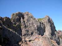
 Pico das Torres seen from the south-west Pico das Torres seen from the south-west |
At 1852m Pico das Torres is the second highest of Madeira's mountains, only surpassed by Pico Ruivo (1861m). Yet, while the latter is somewhat of an anticlimax, Pico das Torres is easily the most impressive mountain in a small but very rugged central range of the island. It consists of a multitude of towers, which gave rise to its name. On all but one side, Pico das Torres drops vertically for several hundred metres with the western side reaching a whooping 1400m until it levels out inside the cauldron of Curral das Freiras.
 |  |  |  |
Like the whole island, Pico das Torres is of volcanic origin, a fact, which becomes obvious on its faces. Many a lava wall cuts across faces and slopes and quite often very impressive rocks have been carved out of the slopes by erosion. The mountain is made up from a mix of tuff and basalt, with the latter giving some solidity to an otherwise very brittle peak.
 |  |  |
Pico das Torres is a mountaineering objective, its normal route is graded V+ and heads up to the summmit along its east ridge. The start of the route can be more or less easily reached by following the eastern branch of the hiking route between Pico do Arieiro and Pico Ruivo. It can be found near the shoulder where the hike crosses Pico das Torre's east ridge. However, the start is not obvious and hard to find. Moreover, in recent years the eastern branch often has been closed because of rockfall, another sign for the poor quality of the rock.
 |  |  |
Also, weather can change swiftly on Madeira's highest mountains. While snow is virtually unheard of you can encounter rime and ice, especially early in the mornings. Even more dangerous are whiteouts by fog and clouds. Pico das Torres is located close to Madeira's weather divide, which separates the humid north from the arid south. Quite often, trade wind clouds start rolling across the mountains around noon, depositing lots of moisture on the unsafe rocks.
Getting There
 Pico das Torres behind Pico do Gato
Madeira can be reached from any of the major European airports. There are almost no regular flights (with the exception of some portugese airports) but quite a lot of charter flights.
Pico das Torres is located centrally in Madeira's central range, with the possible ascents from Achada do Teixeira and Pico do Arieiro.
- Achada do Teixeira
- Follow motorway R101 east towards its end at Machico and head northwest on the coastal highway R101 towards Santana.
- In Santana turn left (filling station, sign: Pico Ruivo) onto a side street which after 14km leads you to Achada do Teixeira.
- Follow motorway R101 east towards its end at Machico and head northwest on the coastal highway R101 towards Santana.
- Pico Arieiro
- From the airport take ER207 to Santo da Serra, switch to ER102, direction Camacha and at Quatro Estradas switch to ER202 to Pico do Arieiro.
- From Funchal take ER103 through Monte to Ribeiro Frio. At Poiso switch to ER202 to Pico do Arieiro.
- From the airport take ER207 to Santo da Serra, switch to ER102, direction Camacha and at Quatro Estradas switch to ER202 to Pico do Arieiro.
Red Tape
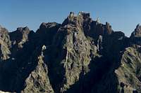
 Pico das Torres seen from Pico do Arieiro
There is no red tape. Parking lots are free of charge. However, take extreme care with fire. There has been a series of forest fires in the last years which destroyed much of Madeira's wonderful vegetaion, especially on the south side of the weather divide.
When To Climb
You can climb this mountain all the year. However, weather can change very quickly. So be prepared for whiteout conditions. Gloves are recommended, warm clothing and wind protection as well, especially in winter.Accommodation
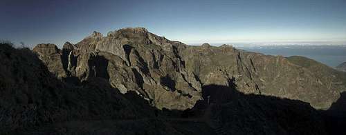
 Pico Ruivo, Pico das Torres, Pico Cidrao
You can find a lot of hotel rooms and apartments on Madeira. Either visit the next travel office or do an internet search. The island is small, all trailheads can be reached by car in an hour from almost anywhere on the island. Most accomodation can be found in the south of the island near Funchal and Camara de Lobos. Camping is not allowed anywhere in the central range.
Weather Conditions
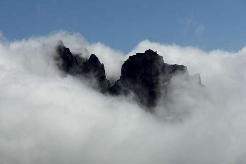 Pico das Torres appearance through the trade wind clouds
Weather conditions cannot be predicted accurately. Madeira is located in the trade wind zone. You almost always encounter northeastern winds which carry a lot of humid air. Being forced to climb to higher altitudes this moisture condenses into clouds. This in return means that most of the time the northern part of the island is covered in clouds from altitudes of 1000m through 2000m.
The mountains themselves - being of the same altitude -finally stop the clouds so that on their southeastern slopes the clouds "run out". Look at the pictures - it looks like the clouds creeping over the weather divide. Boca da Encumeada - being some 500m lower than the surrounding summits - is a gateway for the clouds from north to south. Thus it very often is covered in mist. Unfortunately all of the major peaks of Madeira lie around the weather divide, sometimes within, sometimes just out of the clouds.
The following table shows weather data for Funchal on the southern coast. Be careful with these data if you want to climb the summits...
| Month | Jan | Feb | Mar | Apr | May | Jun | Jul | Aug | Sep | Oct | Nov | Dec |
| Avg. day temp.[°C / °F] | 16 / 61 | 16 / 61 | 17 / 63 | 20 / 68 | 24 / 75 | 27 / 81 | 29 / 84 | 29 / 84 | 27 / 81 | 23 / 73 | 21 / 70 | 17 / 63 |
| Avg. night temp.[°C / °F] | 9 / 48 | 9 / 48 | 10 / 50 | 12 / 54 | 15 / 59 | 19 / 66 | 21 / 70 | 22 / 72 | 19 / 66 | 16 / 61 | 13 / 55 | 11 / 52 |
| Water temp.[°C / °F] | 16 / 61 | 15 / 59 | 16 / 61 | 16 / 61 | 19 / 66 | 22 / 72 | 24 / 75 | 25 / 77 | 24 / 75 | 23 / 73 | 20 / 68 | 17 / 63 |
| Rainy days | 12 | 7 | 8 | 4 | 2 | 1 | 0 | 0 | 2 | 6 | 6 | 10 |
Maps & Books
Maps
- Madeira
Tour & Trail Map
Discovery Walking Guides
1:40000
ISBN: 190494678X
Books
My recommendation is a guidebook by Rother Verlag, available in several languages. The book is an excellent hiking guide covering all the interesting areas of the island. Obviously, it does not contain the final route up Pico das Torres but it contains the access route from Pico do Arieiro or Achada do Teixeira
- Madeira
Rolf Götz
Rother Verlag
ISBN 978-3-7633-4811-4 (English)
ISBN 978-3-7633-4274-7 (German)
ISBN 978-3-7633-4910-4 (French)
ISBN 978-3-7633-4297-6 (Portugese)
ISBN 978-3-7633-4708-7 (Spanish)