
-
 11145 Hits
-
 87.31% Score
-
 24 Votes
|
|
Area/Range |
|---|---|
|
|
46.41080°N / 14.41504°E |
|
|
Hiking, Skiing |
|
|
Spring, Summer, Fall, Winter |
|
|
5912 ft / 1802 m |
|
|
Overview
What's new on this page?
> JUL 12th, 2021: Overview chapter expanded, Plešivec chapter updated.
> JUL 26th, 2020: Geology chapter added.
> AUG 19th, 2019: Virnikov Grintovec chapter updated.
> DEC 28th, 2015: Pečovnik chapter updated.
> APR 22nd, 2015: Bela peč chapter added.
> MAR 20th, 2005: Initial set up of the page.
The area gets presented
On the below interactive map-guidebook, there's on three layers (summits, rotes, other) a lot of information. Take a closer look!
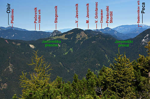
South east of the impressive Košuta, the 120 km long Karavanke range forms a side crest, where a group of smaller mountains is rising. The highest Karavanke range goes towards the east more on the northern side, here, between Tržič and Jezersko, the range hits on the Kamnik and Savinja Alps, and beyond Kokra, above the Jezersko valley, the nature of mountains drastically changes. In this group we shall describe mountains, standing in two crests: the first one is stretching from Košuta to Jezerski vrh / Seeberg Sattle (saddle), the other crest deters from this one towards the south, where on Javorniško sedlo (sadle) it hits the Storžič group, belonging again to Kamnik and Savinja Alps.
Mountains around Stegovnik are primarilly hiking goals. Even if remote, they can be approached by many forest roads, where you can use also a mountain bike. The whole region offers a few really nice, but quite challenging biking tours. Some summits are also nice ski tours goals, especially in winter, when higher mountains are too dangerous because of avalanches. Although some summits have short rocky faces they are not appropriate for technical climbing. Only a few passages of ordinary paths are secured by steel ropes and pegs. And finally, besides solitude, mountaineers will enjoy in these mountains great panoramas - on Kamnik Alps, Karawanks and also towards more distant ranges of Alps.
The area is bordered as seen on the above map. On the NW the valley of Tržiška Bistrica river and its tributary Košutnik is separating our area from the Košuta range. Košutnik ends with the Dolga Njiva meadow, connecting on the SE with Šenkova planina (meadow). That one belongs already to the broad cauldron og Trögern / Korte, which is separated from the E-NE outcrops of Košuta range by the creek of Koschutabach / Košutni Potok. It flows eastwards, finally joining the Trögernbach / Korški potok. Through a beautiful canyon that one flows towards the NE, finally flowing into Ebriachbach / Obirski potok. That one separates out group on the N from Obir massif (Northern Karawanks). The E and SE border of our group is the river Vellach / Bela, flowing through the town of Bad Eisenkappel / Želazna Kapla. Just below the saddle of Seebergsattel / Jezerski vrh, the border of our group leaves Vellach / Bela river, which has its sources in the Kamnik and Savinja Alps. The border rises on the Seebergsattel / Jezerski vrh and descends on the SW side of it into the valley of Jezersko. That tourist resort and Jezernica creek separates our group from Kamnik and Savinja Alps. Further on the SW, Jezernica joins the Kokra river, which has its sources in the middle of our group. Kokra is the border only a short stretch. At the Kanonir inn from the W the creek of Reka joins it and the border follows that creek. separating our group from the Storžič group. But again not long. In Podstoržec the borser leaves the valley of Reka, rises on the Javorniški preval (saddle) and leaves it towards the W. Then the border follows the valley of Lomščica creek, which still separates our group from the group of Storžič. Near Tržič, Lomščica joins the Tržiška Bistrica river.
Geology
All mountains in our group are old relics from the times when Alps even had not existed yet. Their rocks originate from Paleozoic, the oldest are from Devonian period, some good 440 million years old. And yet the origin of all rocks is sedimentary, the highest summits are even made of limestone, rising above younger Carboniferous rocks. The oldest rocks are from the early Devonian, when the sea in the areas where they were deposited by rivers and sterams was quite deep. The most important rocks are up to 600 m thick light, 380 million years old, grey massive reef limestones which were built in the middle Devonian in shallow tropical sea by corals and algae. They build almost all the highest summits of our area, similarly as the main summits of the Eastern Carnic Alps. Then in the upper Devonian the sea became deeper again and some more rare rocks from those times are again made of sediments washed in the sea by rivers. In early Carboniferous period the big continent of Gondwana already colided with the other big continent of that time, Laurussia. The result was creation of a huge mountain chain, when all the mentioned sediments (and others) raised and formed high summits (the process is called Variscan orogeny), of which only a few survived till the present time. In the areas which still stayed submerged deposits were continuing to accumulate. The result were flysh-type sediments which are across Southern Europe called Hochwipfel formation (325 million years old). West of Jezersko they are building the ereas among the summits. In Perm, the last period of Paleozoic the described processes continued. Our mountains were a part of a single, huge continent, called Pangea, but in the sea basins among them some kinds of new rocks (like Trogkofel limestone and sandstones) continued to be created.
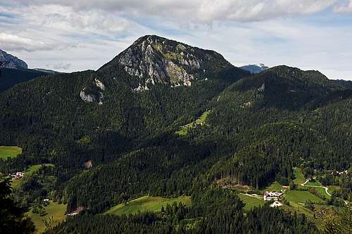
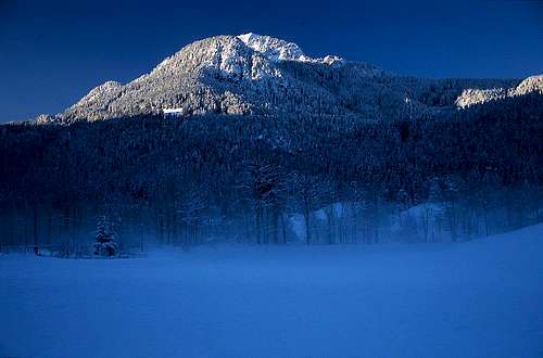
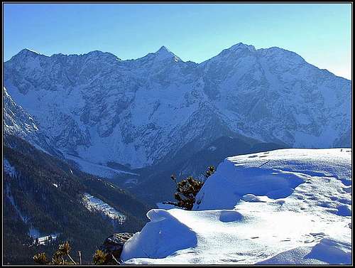
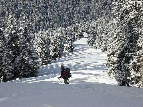
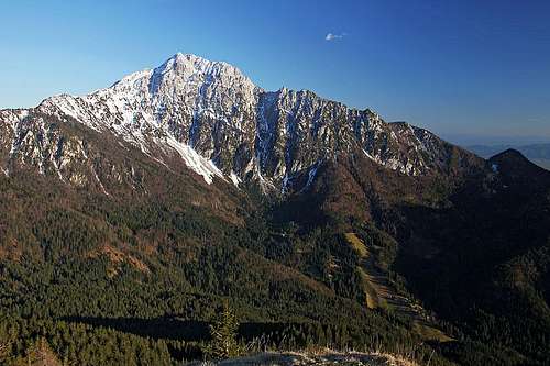
Plešivec, 1802 m

On Plešivec
A winter scene from Plešivec

Košuta from Plešivec
The character
The first mountain SE of Košuta, between Tržiška Bistrica and Korte basin, is almost to the top covered with forest and pine-bush. Its name means 'baldy', so in the past probably it was more grassy on the top, but even in nowadays warm times from its summit the view is opened. The most attractive is the whole range of Košuta, stretching just in front of us. When having enough snow, it offers also a nice ski tour.
Plešivec is quite a broad mountain, but the big majority of it is not attractive for ascents. On the very summit some outcrops of Tarvisian breccia (a nice Permian rock) is seen, beautiful examples of those rocks slided down from the slopes above Šenkova planina and into the Koschutabach / Košutnikov potok. The valley-end of that creek is a wonderful example of a geological interesting landscape, with some nice waterfalls as well. Near the summit of Plešivec a few interesting rock towers made of Permian limestone can be seen as well.
Routes
People almost exclusively reach Plešivec from Dolga njiva alpine meadow (from the west) - 30 minutes from the highest part of the meadow. Where the marked path reaches the saddle on the main crest between Košuta and Plešivec, you turn right and ascend the summit by the clearing, which remained from the times when the state border was still hardly guarded. This is also the normal ski tour. Especially Dolga njiva is in winter a paradise for skiing.
South around the mountain a marked path goes towards Fevča alpine meadow and Pečovnik. From this path to the summit you need to overcome a great obstacle - very dense 'plantages' of pine-bush, where you can only hardly proceed.

But very nice is the ascent by the SE ridge. It's also a short one, because till below Pečovnik two mountain roads reach high - one from the Jezersko, one from Tržič side. From Pečovnik you then only follow the main ridge - and the weak trail from one border marker to another. Three picturesque rock towers just below the summit are detoured by the E side, where the ex frontier trail is nicely cut through dwarf pines. Good 30 min from Pečovnik.
A Memory
I missed the direct path by a frontier clearing and proceeded by the marked path south around. When realised the mistake I said to myself: 'Ok, at least I gained some heigth'. And started to ascend directly up. An early summer day was hot, I soon began fighting with pine-bushes. 'How can these monsters be so dense'! Crawled below, pushed them away, floated over their branches - and came nowhere. Exhausted the whole vocabulary of dirty words and started to repeat them. Nothing helped me. Finally I started crossing, tending to crawl a bit downwards until reached the clearing. Then, reaching the summit was only a matter of minutes.
|
Gallery:
|
|
 |
 |


Pečovnik, 1640 m

At hunters hut above Komatevra

The view on Kamnik Alps
The character
This mountain is more important in a geographical sense than in a mountaineering sense. Here the side ridge deters towards the south. The panorama from the summit is nice.
Routes
Pečovnik can be reached by trails which start on forest roads, ascending quite high on the mountain. From the road, coming up from Tržič side, ending below the Fevča meadow, it can be reached in one hour, from Belščica meadow (on the Austrian side) also in one hour, from Komatevra (Jezersko side) even in a shorter time. In Komatevra, the road is closed between July 20th and October 20th, but outside that period, you can reach by car as high as 1500 m - till the ex Yugoslav frontiers house. From there you continue northwards, reach the state border and go along it a bit towards the left.
 Košuta range from the meadow just below Pečovnik
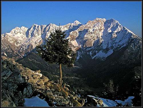
Virnikov Grintavec / Kaerntner Grintoutz, 1654 m
See more on the Virnikov Grintavec / Kärntner Grintoutz mountain page!
Virnikov Grintavec from the south
On the summit of Virnikov Grintavec

The summit panorama
The character
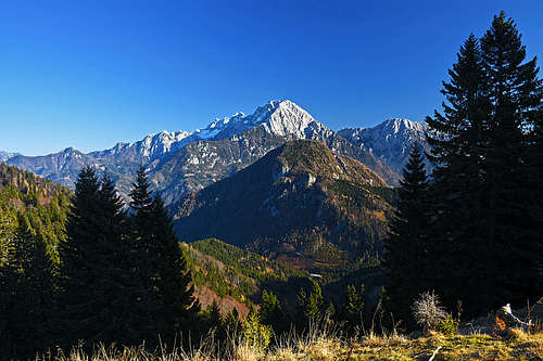
This is a nice mountain, made of quite brittle Devonian reef limestone, which looks fine especially from Jezersko side (from the SE). Its most attractive feature is a great panorama over Jezersko to the north walls of Kamnik Alps.
Routes
The mountain can be reached from Jezersko by marked paths (2 hours), if we use forest roads, we can start walking higher, so shortening the hike considerably. One road goes from Spodnje (Lower) Jezersko into Komatevra valley and from there further up, the other road approaches the mountain from Zgornje (Upper) Jezersko, yet the third one from Jezersko sedlo / Seeberg Sattel and the fourth one from Trögern / Korte (usually closed).
Either by the road or by a marked path we reach from Jezersko the forested ridge Olipov rob, above the Murn farm. Below the ridge of Žarkove peči the marked path goes nortwards, where it soon reaches the main ridge. There it turns left and goes partly by the eastern ridge of Virnikov Grintovec, partly south of it towards the summit. In this part the path is steep and requires some care if wet, snowy or even icy (crampons in this case). Then it approaches the southern summit ridge and in a few steps we are on top. Other ascent routes (from Jezerski vrh / Seebergsattel and from Trögern / Korte) join this route below the East ridge.
A Memory
Late autumn, a very clear, windy day. We are sitting alone, just below the summit, enjoying the fantastic view towards Kočna and Grintovec. Suddenly high above us a big bird shows up. It gains altitude, does a few circles, we can still clearly distinguish the characteristic wings - it's an eagle! Then the big bird decides to take the direction over Jezersko valley towards the east. With a help of the west wind the bird gains an incredible speed. You can't say how fast, but it goes like a jet fighter. In a few seconds it disappers and we remain sitting there, asking ourselves if that was true or just a beautiful dream!
And a Second Memory

If it's such a beautiful day, you can shorten the working Friday. But it's 5:30 p.m. when I reach Jezersko. I'm hiking around, shooting pictures, then I'm driving down and into the Kokra valley. I have no map so I miss the forest road right upwards. My road soon ends and I take by foot a cart-road approximately in my direction. Then I go directly upwards over a steep forest slope, hit another path and leave it again, until below what seem to be the summit rocks I'm totally doomed. A hunters passage climbs up a sharp ridge, then crosses steep western slopes to avoid rocks. It's already snow up here, so I must be careful. On a steep scree slope I can track hunters passages no more. So, directly upwards! In a ravine it gets so steep that I must pull up with hands, steep grass, rocks, some pine-bushes and the outcome of my passage is uncertain. Dude, Vid! Perhaps nobody ever went here. Finally I exit - just on the summit. And it's time, because Kamnik Alps on the other side of Jezersko valley are receiving the last sunrays. Still, I long enjoy the beautiful panorama. I don't care if I'll have to run down.
 |
 |
Pristovški Storžič / Kaerntner Storschitz, 1759 m
See more on the Pristovški Storžič / Kärnther Storschitz mountain page!
Pristovški Storžič
The character
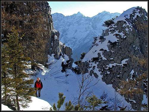
As the second highest mountain in this group is standing just above Jezersko sedlo / Seeberg Sattel, the saddle where the main road crosses these mountains, it is often visited. Perhaps from its summit one has the best view on Kamnik Alps from north. The east face of the mountain is rocky, all other sides are covered with woods and higher with pine-bush. In the east face even one clibming route is recorded - V. Wolf v. Glanvell, September 19th, 1901.
Routes
The shortest approach comes to the summit from the road pass. On the Austrian side we first follow a good forest road (some 300 m), then the marked path goes over an alpine meadow and through the forest, until it becomes steep and exposed. Here the route is secured with pegs and steel ropes. Through a short ravine we climb to the notch in the south ridge and on the other side proceed by the western slopes. Through pine bushes the path reaches the open summit ridge and the summit itself. 1 h 45 min. Much longer are approaches from the north and west (Troegern/Korte).
|
|
Gallery:
 |
 |

|
Veliki vrh, 1634 m
A completely unimportant forested summit SW of Pečovnik. It can be reached by the same paths and forest roads and in the summit part by pathless terrain. The forested saddle NE of the summit is called Brsna lesa (a marked trail crosses it), towards the S a longer forested ridge goes on the ex Fevča meadow.
Ruš, 1614m

On the summit of Ruš
A scene below the summit of Ruš - Storžič
From Komatevra valley or from Mali Javornik this summit looks quite sharp, but its importance is quite a minor one. It has steep slopes, down to Komatevra valley also rocky ones, but covered with woods almost to the top. It is rarely visited, but the view from its summit is almost equally beautiful as from the nearby Stegovnik.
Ascent
Reaching Fevča meadow (either from the south or from the north), we have just one small jump on the summit of Ruš: A good, unmarked path leads us towards the east and in a short ascent soon reaches the SW ridge. Already from that point we have a nice view, but it's worth continuing a bit more towards the left on the very summit of Ruš. That one is decorated (2011) by a bench and an interesting root in a form of a "skater", but resembling also a usual summit cross.
Štegovnik, 1691 m
See more on the Štegovnik mountain page!
Stegovnik western view

Stegovnik from the SW

The character
Štegovnik is not the highest mountain of this area, but in a way it is privileged, being broad, rocky, for this altitude nice looking from all sides. As some easy rock climbing is needed for the ascent from any side, we should consider if visiting it in times when paths can be covered with snow or even ice. Its long summit ridge offers besides a nice view all around also a decent rocky scenery. On the lower parts it seems that the rocky structure is not so difficult. On the south-western part, one of the marked routes leads us through a nice, quite big natural rock window, on the eastern part the mountain is hiding also a cave.
Routes
Stegovnik can be best ascended from the south-western side. We use the forest road (bike?), which ascends on the mountain from Medvodje, the road, coming till below the summit from Lom, or the road to Javornik alpine meadow. Using any of these, we must reach the saddle between Mali Javornik and Stegovnik. From there the marked path takes us through the window in rocks of the SW face, later it climbs on the main ridge and follows it to the summit ridge. It still takes us some 15 minutes to get to the highest point on the other side of the summit ridge. The other option to ascend Štegovnik is from Jezersko side. A steep forest road and a cart road takes us high below the saddle on the NE side of the mountain, from there an airy path takes us to the top.

Evening on Stegovnik
A Memory
It's been a few years since I hardly reached the summit in winter conditions. It's autumn now and we shall certainly be able to make it up there with small children. Well, now we are on the top of summit rocks. Both kids are enjoying the summit feeling, but with Jasmina we are a bit scared - we shall again struggle down with small children in a complete darkness.
Mali Javornik, 1684 m
"Patricians and plebeians"
The character
This is a quite fine summit south of Stegovnik, less appropriate for an independent tour, but nice in a combination with its bigger brother Ženiklovec (Veliki Javornik). On three sides it's covered with a forest almost to the top, only its last meters are grassy, on the NE side it has a rock face. So the summit offers the same nice panorama as its neighbours. In winter a ski tour can be done from the summit, but the best descent through one of its ravines towards west is still unknown to me.
Routes
The finest ascent comes from Javornik alpine meadow, either over the summit of Ženiklovec or by the marked path which crosses the western slopes of this crest. From the saddle between Ženiklovec and Mali Javornik in 30 minutes to the top. From Javornik meadow 1 h 30 min. The other option is the road which ascends below Štegovnik from Medvodje. We ascend first the saddle between Štegovnik and Mali Javornik and from there to the top. Some 2 hours. From Jezersko side we can ascend the summit from Dol valley in some 2 hours.
A Memory
It's April, snow is fastly melting and I'm hiking along the crest from Ženiklovec to Mali Javornik. While above the grassy ridge is still covered with snow, some 100 meters lower I can enjoy in abundance of spring flowers. This is the best way how the nature convinces me of life power. Around a strong tree there's still some 50 cm of snow. But, must be only in the last few days, the circle around the tree has melted and now it is already densely covered with flowers.
Ženiklovec or Veliki Javornik, 1716 m
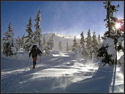
Skiing from Veliki Javornik (Ženiklovec)
The character
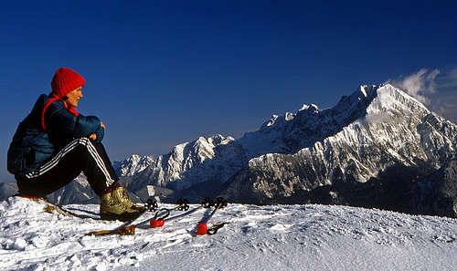
This summit is so different from the rest of them in this group, that it would perhaps deserve even its own page. Nice grassy slopes, an alpine meadow below the summit with quite some huts, frequently visited. This summit was a great surprise when we visited it for the first time. "How is it possible, that, so hidden behind Storžič, it offers such a nice panorama?" And skiing down was like a beautiful dream. That video is still the best I have ever made. So, Ženiklovec is used as the mountain of the first snow criteria. When fresh snow falls, you drive as long as you can into the Lom valley and then continue to the summit. Skiing down can be done over many meadows, not only on the summit part of the mountain. Perhaps a few pictures on this page can also convince you.
Routes
From the alpine meadow below, the Javornik meadow (and hut) can be reached in good 30 minutes, the summit in 1 hour. Nice is also the marked path, coming to the Javornik meadow from the summit of Storžič or from Dom pod Storžičem (hut). From the parking place below Storžič it's 1 h to Javorniški preval (saddle), 20 more minutes to Javorniška planina (meadow) and 30 more minutes on the summit.
A Memory
Half meter of a fresh powder snow. I'm just sinking down towards the hut. Without stopping, the whole slope in one dreamy ride. Then I'll go up again...
|
|
|
Gallery - skiing:
 |

|

|

|
 |
 |
 |
 |
Bela peč, 1583 m
The magnificent view on Storžič from Bela peč
The character
The rocky promontory of Bela peč, peeking only a little out of the forested area north of Lom valley, would be completely unimportant, if it did not have two excellent features:
> The view from its top on Storžič north face is unsurpassable.
> In the 150 m high crags there are some 40+ climbing routes in good rock.
On-line guide - Milan Meglič: Bela peč, 2004.
So, the narrow summit is a nice hiking destination and the whole area is also a paradise for mountain biking. Otherwise the plateau-like world NW of the summit hosts also a few nice alpine meadows, worth of a visit.
The best approach to Bela peč area is from the Lom valley. In the last village, Grahovše we drive up till the last farm, where the road is blocked by a ramp. It opens with a coin of 1 EUR (Have also one for the return!). For both approaches, described below, you can use also a mountain bike (and even combine everything in a longer round tour).
Routes
Mountain roads encircle the summit of Bela peč. To reach its top, there are two general variants:
1. East approach. From Grahovše you hike (ride or drive) by the road right, eastwards, towards the Javornik meadow. Above Gabrčev rovt (meadow), after the road ascends towards Bela peč, there is a big right turn on the road. From it we continue some 500 m more by the road towards Javornik meadow, then 2 marked paths deter to the left:

The arrival in Bela peč
> The first path crosses the slopes back (just above the road), and then westwards till below the vertical south wall of Bela peč. Here climbers go to reach their trailheads. Below the crag there is a memorial plate to Jože Rozman, a local climber who died on Kanchenjunga. From below the wall a narrow, not marked path continues westwards along the crag, and then northwards up on the top. This tiny path requires some care and is more demanding (T3) than the approach path. Altogether some more than 30 min from the road.

The south crags of Bela peč
> The second path deters left from the road a bit later (also inscription), on the place where the road starts slightly descending. The marked path goes westwards directly towards the summit. It is easy, only one short section crosses very steep slopes (Carefully, if icy!). Some 20 min to the top, T2.

Lom valley from Bela peč
2. West approach. This approach is easy (T2), but much longer than the one from the east. It goes over nice meadows. From the ramp we go a few minutes by the road towards the east and then on the first crossroads take the left road - to Konjščica meadow. We first walk towards the NW, then towards the N. On some 1280 m a marked path deters right. That's the shortcut which reaches higher on the road again, on some 1400 m. Then we continue right (eastwards) and soon reach the beautiful Lower Konjščica (meadow), 1451 m. From it a cart road continues eastwards, on Zgornja Konjščica, 1571 m, and a bit more towards the SE, where we reach a broad, forested main ridge. To the summit of Bela peč we have only a few more minutes.
Zimpaser / Cimpesar, 1547 m
Northeast of Kärntner Storschitz / Pristovški Storžič, there's between the valleys of Trögernbach / Korški potok and Vellach / Bela a rather independent summit, called Zimpaser / Cimpesar. It's mostly overgeown, but from some clearings there are nice views on Kamnik and Savinja Alps. No marked trail reaches the summit. The easiest approach is coming from the S (from the Kristansattel / Kristanovo sedlo, 1225 m), the N and E approaches are in their highest part more demanding.
Getting There
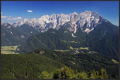
Jezersko resort and Kamnik Alps above it
For the broader overview see the Karavanke/Karawanken page!
The first option to reach trailheads is the valley of Tržiška Bistrica (drive through Tržič town). For the summits of Javornik, Bela peč and Stegovnik you can start on the parking place at the end of Lom valley, or drive a bit higher towards Javorniška planina (meadow). Other summits can be approached from mountain roads which branch in Medvodje. From that crossroads you can drive quite high up towards the east below Stegovnik, Ruš, Veliki vrh and Pečovnik. The last option is to drive from medvodje towards the north and park below Dolga njiva (alpine meadow). From there you can ascend Plešivec.

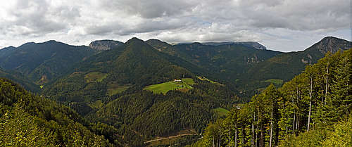
Late autumn in Dol
The second valley to start the tours in this area is Jezersko and its side valleys. The first side valley (from below) is Reka valley into which from the north Zabukovski potok flows. There you can park just above Dol, on some 800 m. The second valley is Komatevra, through which Kokra river flows. Through this valley you can drive up almost to the main ridge (below Ruš and Pečovnik, or you can soon deter right to the trailhead below Virnikov Grintavec. From Zgornje (Upper) Jezersko many short side valleys go towards the north and west. And finally you can start the tour on Jezersko sedlo (saddle), the main pass from this valley over the border to Austria. There the tour on Pristovški Storžič starts.
From the Austrian side these mountains can be reached by the main road which runs through the valley of Bela. Eisenkappel / Zelezna Kapla is the town in the lower part of the valley. From Eisenkappel / Zelezna Kapla a good road goes towards the west, following the valley of Obirski potok. This valley divides the massif of Obir from Košuta and our mountain massif. From this road towards the south a road goes to Troegern / Korte. Hamlets and farms in this valley and roads leading to and through them, enable ascents on our summits from north.
 |
 |
Red Tape
There are no limitations.
When To Climb
These summits can be climbed throughout the whole season. Though, in deep snow some ascents can become very tedious if not impossible. Also take care that some harder routes may not be passable in winter or in hard conditions.
Huts and Camping
To ascend any of the summits huts are not really needed. These are all one-day hikes. So, there are no mountain huts. A few private huts offer food in summer, for example on Javornik meadow, Dolga Njiva meadow (under Koschuta), Medvodje, in Troegern/Korte.
Jezersko is a well developed tourist resort. There you can find any type of accomodation. Eisenkappel / Zelezna Kapla is a spa, for tourism also farms north of our massif are developed.