
-
 10059 Hits
-
 81.84% Score
-
 14 Votes
|
|
Mountain/Rock |
|---|---|
|
|
46.73730°N / 13.39650°E |
|
|
Hiking, Skiing |
|
|
Spring, Summer, Fall, Winter |
|
|
7335 ft / 2236 m |
|
|
Overview
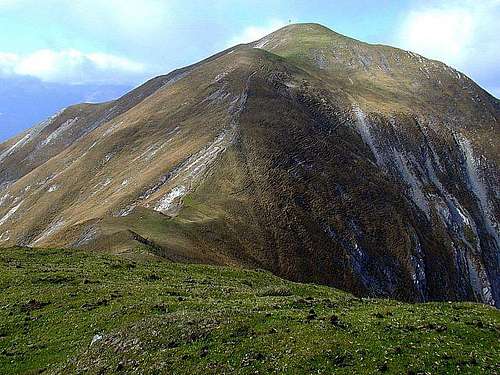
The summit of Latschur
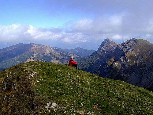
The views towards Staff
What's New On This Page?
> Jan 19th, 2019: Design corrections.
> Sep 14th, 2014: Images attached.
> Aug 25th, 2005: Initial page setup.
Presenting Latschur
While some peaks of Gailtal Alps outside Lienz Dolomites can also be rocky and sharp, Latschur, although being the highest in its small subgroup, is a massive, rounded, grassy mountain (except a part of its N face). It's hard to say that it's not attractive for mountaineering, especially in winter skiing down those broad slopes must be very nice and hard too, but it really doesn't offer other than a walk-up and, on the summit, a broad panorama. Still, the broader surrounding is nice. A special pearl is Weissensee (White Lake), 930 m, on the southern end of Latschur subgroup, a big, crystal clear and warm enough lake, which is turistically exploited, but never really crowded. There's no road around the lake, only paths and broad pine forrests. High above the lake, on all the slopes of the mountain there are broad alpine meadows. And these summits, meadows and panoramic points are connected with a dense network of marked paths. The map below shows only some of them.
The Latschur subgroup consists of some more or less distinguished peaks, three of them being candidates for real autonomous mountain hikes. Latschur, 2236 m is the highest. East of it, the beautiful Staff, 2217 m, stands. The ridge between both is the backbone of this small subgroup, carrying summits: Almspitz, 2180 m, Eckwand, 2221 m and Kopasnock, 2087 m. North-east of Staff, Goldeck, 2142 m, stands relatively independently. From the summit of Latschur one ridge is going towards the north, lowering significantly after the bump of Kreuzbuehl, 2060 m, and the other ridge is going towards the west, lowering significantly after the bump of Huehnerspitz, 2002 m. One strong ridge is also deterring towards the south from Almspitz, first forming the broad saddle of Stosia, 1800 m, and there starting to turn slowly in a long arc towards the western direction, carrying some summits, which are already sunken in deep forrests, however.
Besides hiking in summer and tour skiing in winter season the Latschur subgrup is popular also by the Goldeck ski resort. The cableway from Spittal in the Drau valley brings on this rounded mountain big crowds almost each nice weekend.
Weissensee

On the N shore

Winter fun
This beautiful, 11.6 km long lake lies on the altitude of 930 m, has a size of 6.5 km² and reaches a depth of 99 m. In the last ice age (about 70,000 to 10,000 years ago) the glacier, sliding eastwards, carved a deep valley and after the ice melted, it was filled with a clear mountain water.
The lake can be reached by motor roads, but only its western end and eastern end separetely. Fortunately no public road connects both ends of the lake, thus ensuring peace on shores. The western shore is turistically more developed than the eastern one. On both you can rent a boat to exercise some rowing along the lake shores.
Getting There and Tours List
|
Latschur can be reached from all sides. But as public roads don't go up the mountain ascents are still quite long. For more information about the broader area see the Gailtal Alps page! From the NE, Latschur can be reached from the upper station of Goldeck Cableway (some 4 hours). The cableway goes up on Goldeck from Spittal in the Drau valley. As an idea - can this approach also be a nice ski tour? From NW, Latschur can be reached by marked paths from the Drau valley, from the villages of Lind and Fellbach. The ascent by cart-roads and marked paths should last some 5 hours (1600 m of altitude). From the S, Latschur can be reached from the eastern shore of Weissensee. The ascent by a good marked path lasts some 3-4 hours (1450 m of altitude). In the guidebook (for Kaerntn) this is also recommended as a middle to hard ski tour (3-4 hours ascent). |
Red Tape
No limitations.
When To Climb
Latschur can be climbed all the year. For hiking the best months are early summer and July to October. For tour skiing the best months are Februar to April.
Huts and Camping
As any ascent can be done in one day, there's no real need for sleeping on the mountain (except if hiking all around the place).
Below Goldeck summit there's the Goldeckhuette, 1945 m, opened from End of May till end of October. Tel.: +43 650 9456348.
On the eastern shore of Weissensee there's a nice camping place. There are also camping places in the Drau valley.